Identification_Information:
Citation:
Citation_Information:
Originator: U.S. Geological Survey (USGS), Coastal and Marine Geology (CMG)
Publication_Date: 20081216
Title:
Geodetic data of field activity U-13-96-OA in Kailua Bay
(Boat Ramp)Oahu, Hawaii from 08/24/1996 to 08/24/1996
Publication_Information:
Publisher: U.S. Geological Survey (USGS), Coastal and Marine Geology (CMG)
Online_Linkage: http://walrus.wr.usgs.gov/infobank/gos/u-13-96-oa.fmeta.xml
Online_Linkage: http://walrus.wr.usgs.gov/infobank/u/u1396oa/html/u-13-96-oa.meta.html
Description:
Abstract:
University of Hawaii,United States Geological Survey, Menlo
Park, California. Chief Scientist: Bruce Richmond. Geodetic
data (geodetic, navigation) of field activity U-13-96-OA in
Kailua Bay (Boat Ramp)Oahu, Hawaii from 08/24/1996 to
08/24/1996,
http://walrus.wr.usgs.gov/infobank/u/u1396oa/html/u-13-96-oa.meta.html.
Purpose:
These data and information are intended for science
researchers, students from elementary through
college, policy makers, and general public.
Supplemental_Information:
Equipment Used -
geodetic data directory exists
navigation data directory exists
Notes -
Other field activities at Kailua Bay (Boat Ramp)
on Oahu also have Activity IDs beginning with "U-1" and ending with "-OA"
Cross-shore beach profile data were collected as a component of
the Hawaii Coastal Erosion Study, a cooperative effort by U.S.
Geological Survey and University of Hawaii in order to document
seasonal and longer-term variations in beach volume and behavior.
The overall objectives of the Hawaii Coastal Erosion Study are to
document the recent history of shoreline change in Hawaii and to
determine the primary factor(s) responsible for coastal erosion
in low-latitude environments for the purpose of predicting future
changes and to provide quality scientific data that is useful to
other scientists, planners, engineers, and coastal managers.
The overall strategy consists of first quantifying the magnitude
and location of serious erosion problems followed by close monitoring
of coastal change in critical areas. Bi-annual beach profiles have
been collected at over 40 critical beach sites on the islands of Oahu
and Maui. Once sufficient background information is analyzed and key
problems are defined, field sites will be selected for detailed process-
oriented studies (both physical and biological) to gain an understanding
of the complex relationships between reef carbonate production, sediment
dispersal, and the interaction of man-made structures with sediment
movement along the shore.
Information derived from this project will be used to develop general
guidelines for sediment production, transport, and deposition of low-
latitude coasts. Planned major products include a comprehensive atlas of
coastal hazards, journal articles and reports presenting results of our
studies, and a "living" database of shoreline history and changes based
on results of the beach profile monitoring and softcopy photogrammetric
analysis.
Cross shore beach profiles were measured using a Geodimeter
464 total station and swimming rodman. The total station was
set up at a non-specific position on the beach. Up to five
permanent reference points were first surveyed in order to
establish the position of the station relative to the established
profile line. Beach profile measurements were then taken from
a point landward of the active beach to as far offshore as
conditions would allow (typically -4m water depth). Specific
morphologic features (high water, berm crest, top of beach toe,
etc.) were noted. Data were post-processed as follows Survey data
were downloaded from the Total Station memory, automatically
creating a RAW file and an associated JOB file. The RAW file
was used to generate a PTS file (UTM field coordinates are
extracted from the RAW file) Note: no recalculation is performed
on the original file). PFCODE.EXE was used on the JOB file to
generate an ED file. The ED file was edited to include necessary
Program 10 information, Points block listing, and INFO codes.
Field procedures were checked and corrected as necessary.
PFGD.EXE was used on the ED file to generate a PF file (Cartesian-
based, relative XYZ coordinates). Extraneous lines were removed
from the PF file to generate a DAT file (relative XYZ coordinates) DAT
files were compiled into a SUMMARY file (Excel) format, plotted,
and where necessary, corrected relative to a primary reference point.
Where GPS positions of the reference points were available, the entire
summary file was re-referenced to an absolute vertical elevation
(meters above the Local Hawaii Tidal datum).
Similar information is available for thousands
of other USGS/CMG-related Activities.
If known, available are Activity-specific
navigation, gravity, magnetics, bathymetry,
seismic, and sampling data; track maps; and
equipment information; as well as summary
overviews, crew lists, and information
about analog materials.
If available, access to physical samples is
described in the "WR CMG Sample Distribution
Policy" at:
http://walrus.wr.usgs.gov/infobank/programs/html/main/sample-dist-policy.html
Primary access to the USGS/CMG Information
Bank's digital data, analog data, and
metadata is provided through...
http://walrus.wr.usgs.gov/infobank/
This page accomodates a variety of search
approaches (e.g., by platform, by region,
by scientist, by equipment type, etc.).
Time_Period_of_Content:
Time_Period_Information:
Range_of_Dates/Times:
Beginning_Date: 19960824
Ending_Date: 19960824
Currentness_Reference: ground condition
Status:
Progress: Complete
Maintenance_and_Update_Frequency: As needed
Spatial_Domain:
Bounding_Coordinates:
West_Bounding_Coordinate: -157.72311
East_Bounding_Coordinate: -157.72311
North_Bounding_Coordinate: 21.39560
South_Bounding_Coordinate: 21.39560
Keywords:
Theme:
Theme_Keyword_Thesaurus: ISO 19115 Topic Category
Theme_Keyword: geoscientificinformation
Theme_Keyword: oceans
Theme:
Theme_Keyword_Thesaurus: USGS CMG InfoBank
Theme_Keyword: Marine Geology
Theme_Keyword: Geodetic Survey
Place:
Place_Keyword_Thesaurus: USGS CMG InfoBank
Place_Keyword: Central Pacific Ocean
Place_Keyword: HW
Place_Keyword: Hawaii
Place_Keyword: Kailua Bay (Boat Ramp)
Place_Keyword: Molokai, HI (North)
Place_Keyword: North Pacific Ocean
Place_Keyword: Northern Pacific Ocean
Place_Keyword: Oahu
Place_Keyword: Oahu, HI
Place_Keyword: USA
Place_Keyword: aii
Access_Constraints:
Physical materials are under controlled on-site access.
If available, access to physical samples is described
in the "WR CMG Sample Distribution Policy" at:
http://walrus.wr.usgs.gov/infobank/programs/html/main/sample-dist-policy.html
Use_Constraints:
Please recognize the U.S. Geological Survey (USGS) as
the source of this information.
Physical materials are under controlled on-site access.
Some USGS information accessed through this means
may be preliminary in nature and presented without
the approval of the Director of the USGS. This
information is provided with the understanding
that it is not guaranteed to be correct or complete
and conclusions drawn from such information are
the responsibility of the user.
This information is not intended for navigational
purposes.
Any use of trade, firm, or product names is for
descriptive purposes only and does not imply
endorsement by the U.S. Government.
Point_of_Contact:
Contact_Information:
Contact_Organization_Primary:
Contact_Organization: U.S. Geological Survey (USGS), Coastal and Marine Geology (CMG)
Contact_Person: Clint Steele
Contact_Position: Data Acquisition, Processing, and Storage (DAPS) Group Leader
Contact_Address:
Address_Type: mailing and physical address
Address: USGS, MailStop 999, 345 Middlefield Road
City: Menlo Park
State_or_Province: CA
Postal_Code: 94025-3561
Country: USA
Contact_Voice_Telephone: (650) 329-5055
Contact_Facsimile_Telephone: (650) 329-5190
Contact_Electronic_Mail_Address: csteele@usgs.gov
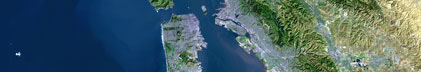
Browse_Graphic:
Browse_Graphic_File_Name: http://walrus.wr.usgs.gov/infobank/u/u1396oa/html/u-13-96-oa.nav.gif
Browse_Graphic_File_Description: Trackline map of U-13-96-OA
Browse_Graphic_File_Type: GIF
Native_Data_Set_Environment: Digital, ASCII
Cross_Reference:
Citation_Information:
Originator: U.S. Geological Survey (USGS), Coastal and Marine Geology (CMG)
Publication_Date: Unknown
Title: USGS/CMG Information Bank
Publication_Information:
Publisher: U.S. Geological Survey (USGS), Coastal and Marine Geology (CMG)
Other_Citation_Details: Updated daily
Online_Linkage: http://walrus.wr.usgs.gov/infobank/
Data_Quality_Information:
Attribute_Accuracy:
Attribute_Accuracy_Report: Identified as best available version.
Logical_Consistency_Report: Unspecified
Completeness_Report:
Start and end date/times of data
>Navigation Data (u-13-96-oa.060 [GPS])
>YYYYMMDDHHMMSST YYYYMMDDHHMMSST
>199608240000000 199608240000000
>YYYYMMDDHHMMSST YYYYMMDDHHMMSST
Positional_Accuracy:
Horizontal_Positional_Accuracy:
Horizontal_Positional_Accuracy_Report: Unspecified
Vertical_Positional_Accuracy:
Vertical_Positional_Accuracy_Report: Unspecified
Lineage:
Process_Step:
Process_Description:
Navigation Data
Unknown
Process_Date: 20021023
Process_Contact:
Contact_Information:
Contact_Organization_Primary:
Contact_Organization: U.S. Geological Survey (USGS), Coastal and Marine Geology (CMG)
Contact_Person: Clint Steele
Contact_Position: Data Acquisition, Processing, and Storage (DAPS) Group Leader
Contact_Address:
Address_Type: mailing and physical address
Address: USGS, MailStop 999, 345 Middlefield Road
City: Menlo Park
State_or_Province: CA
Postal_Code: 94025-3561
Country: USA
Contact_Voice_Telephone: (650) 329-5055
Contact_Facsimile_Telephone: (650) 329-5190
Contact_Electronic_Mail_Address: csteele@usgs.gov
Spatial_Data_Organization_Information:
Indirect_Spatial_Reference: Kailua Bay (Boat Ramp)
Direct_Spatial_Reference_Method: Point
Point_and_Vector_Object_Information:
SDTS_Terms_Description:
SDTS_Point_and_Vector_Object_Type: Point
Spatial_Reference_Information:
Horizontal_Coordinate_System_Definition:
Geographic:
Latitude_Resolution: 0.00001
Longitude_Resolution: 0.00001
Geographic_Coordinate_Units: Decimal degrees
Geodetic_Model:
Horizontal_Datum_Name: North American Datum of 1983
Ellipsoid_Name: Geodetic Reference System 80
Semi-major_Axis: 6378137
Denominator_of_Flattening_Ratio: 298.257
Vertical_Coordinate_System_Definition:
Depth_System_Definition:
Depth_Datum_Name: Local surface
Depth_Resolution: 0.1
Depth_Distance_Units: meters
Depth_Encoding_Method: Attribute values
Entity_and_Attribute_Information:
Overview_Description:
Entity_and_Attribute_Overview: Navigation with Time Stamp
Entity_and_Attribute_Detail_Citation:
Global positioning system (GPS) data
>Mnemonic: (Year, Day, Hour, Min, Sec, Tenths, Latitude, Longitude)
>FORTRAN format: (i4.4, i3.3, 3i2.2, i1.1, t16, f9.5, t26, f10.5)
>C format: (%4.4i%3.3i3%2.2i%1.1i %9.5f %10.5f\\n)
>Naming: .060
Distribution_Information:
Distributor:
Contact_Information:
Contact_Organization_Primary:
Contact_Organization: U.S. Geological Survey (USGS), Coastal and Marine Geology (CMG)
Contact_Person: Clint Steele
Contact_Position: Data Acquisition, Processing, and Storage (DAPS) Group Leader
Contact_Address:
Address_Type: mailing and physical address
Address: USGS, MailStop 999, 345 Middlefield Road
City: Menlo Park
State_or_Province: CA
Postal_Code: 94025-3561
Country: USA
Contact_Voice_Telephone: (650) 329-5055
Contact_Facsimile_Telephone: (650) 329-5190
Contact_Electronic_Mail_Address: csteele@usgs.gov
Resource_Description: Downloadable Data U-13-96-OA data set
Distribution_Liability:
Please recognize the U.S. Geological Survey (USGS) as
the source of this information.
Physical materials are under controlled on-site access.
Some USGS information accessed through this means
may be preliminary in nature and presented without
the approval of the Director of the USGS. This
information is provided with the understanding
that it is not guaranteed to be correct or complete
and conclusions drawn from such information are
the responsibility of the user.
This information is not intended for navigational
purposes.
Any use of trade, firm, or product names is for
descriptive purposes only and does not imply
endorsement by the U.S. Government.
Standard_Order_Process:
Digital_Form:
Digital_Transfer_Information:
Format_Name: ASCII
File_Decompression_Technique: No compression applied
Transfer_Size: 0.1
Digital_Transfer_Option:
Online_Option:
Computer_Contact_Information:
Network_Address:
Network_Resource_Name: http://walrus.wr.usgs.gov/infobank/u/u1396oa/html/u-13-96-oa.nav.html
Fees: None
Metadata_Reference_Information:
Metadata_Date: 20081216
Metadata_Contact:
Contact_Information:
Contact_Organization_Primary:
Contact_Organization: U.S. Geological Survey (USGS), Coastal and Marine Geology (CMG)
Contact_Person: Clint Steele
Contact_Position: Data Acquisition, Processing, and Storage (DAPS) Group Leader
Contact_Address:
Address_Type: mailing and physical address
Address: USGS, MailStop 999, 345 Middlefield Road
City: Menlo Park
State_or_Province: CA
Postal_Code: 94025-3561
Country: USA
Contact_Voice_Telephone: (650) 329-5055
Contact_Facsimile_Telephone: (650) 329-5190
Contact_Electronic_Mail_Address: csteele@usgs.gov
Metadata_Standard_Name: FGDC Content Standards for Digital Geospatial Metadata
Metadata_Standard_Version: FGDC-STD-001-1998
Metadata_Time_Convention: universal time
Metadata_Access_Constraints: none
Metadata_Use_Constraints: none
|