- Title:
-
Sidescan Sonar and Video data of field activity M-1-05-NC in
North-central California coast from 04/22/2005 to 05/05/2005
- Abstract:
-
United States Geological Survey, Menlo Park, California,Gulf
of the Farallones National Marine Sanctuary,Monterey Bay
Aquarium Research Institute,Monterey Bay National Marine
Sanctuary,Moss Landing Marine Laboratories,Point Reyes Bird
Observatory. Chief Scientists: Roberto Anima, John Chin.
Sidescan Sonar and Video data (navigation) of field activity
M-1-05-NC in North-central California coast from 04/22/2005
to 05/05/2005,
<http://walrus.wr.usgs.gov/infobank/m/m105nc/html/m-1-05-nc.meta.html>.
- Supplemental_Information:
-
Equipment Used -
navigation data directory exists
Notes -
Associated cruises in northern California:
<br>
<A HREF="<http://walrus.wr.usgs.gov/infobank/m/m103nc/html/m-1-03-nc.meta.html>">M-1-03-NC</A>
<A HREF="<http://walrus.wr.usgs.gov/infobank/m/m104nc/html/m-1-04-nc.meta.html>">M-1-04-NC</A>
<A HREF="<http://walrus.wr.usgs.gov/infobank/m/m105nc/html/m-1-05-nc.meta.html>">M-1-05-NC</A>
<HR>
Collaboration with Gulf of the Farallones National Marine Sanctuary (GFNMS),
Fort Mason, Building 201, San Francisco, CA 94123 (Jan Roletto)
Monterey Bay Aquarium Research Institute (MBARI), 7770 Sandholt Road, Moss Landing, California 96039-9644(Chris Grech)
Monterey Bay National Marine Sanctuary (MBNMS), 299 Foam Street, Monterey, CA 93940 (Jean de Marignac)
Moss Landing Marine Laboratories (MLML), 8272 Moss Landing Road, Moss Landing, California 95039 (Lee Murai)
Point Reyes Bird Observatory (PRBO), 4990 Shoreline Highway, Stinson Beach, California 94970 (Sue Abbott)
Similar information is available for thousands
of other USGS/CMG-related Activities.
If known, available are Activity-specific
navigation, gravity, magnetics, bathymetry,
seismic, and sampling data; track maps; and
equipment information; as well as summary
overviews, crew lists, and information
about analog materials.
If available, access to physical samples is
described in the "WR CMG Sample Distribution
Policy" at:
<http://walrus.wr.usgs.gov/infobank/programs/html/main/sample-dist-policy.html>
Primary access to the USGS/CMG Information
Bank's digital data, analog data, and
metadata is provided through...
<http://walrus.wr.usgs.gov/infobank/>
This page accomodates a variety of search
approaches (e.g., by platform, by region,
by scientist, by equipment type, etc.).
- How should this data set be cited?
U.S. Geological Survey (USGS), Coastal and Marine Geology (CMG), 20081216, Sidescan Sonar and Video data of field activity M-1-05-NC in North-central California coast from 04/22/2005 to 05/05/2005: U.S. Geological Survey (USGS), Coastal and Marine Geology (CMG).
Online Links:
- What geographic area does the data set cover?
- West_Bounding_Coordinate: -123.60709
- East_Bounding_Coordinate: -121.65201
- North_Bounding_Coordinate: 38.14188
- South_Bounding_Coordinate: 35.95932
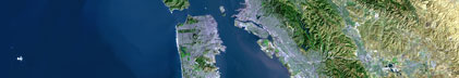
- What does it look like?
- <http://walrus.wr.usgs.gov/infobank/m/m105nc/html/m-1-05-nc.nav.gif> (GIF)
-
Trackline map of M-1-05-NC
- Does the data set describe conditions during a particular time period?
- Beginning_Date: 22-Apr-2005
- Ending_Date: 05-May-2005
- Currentness_Reference: ground condition
- What is the general form of this data set?
- How does the data set represent geographic features?
- How are geographic features stored in the data set?
- Indirect_Spatial_Reference: North-central California coast
This is a Point data set.
It contains the following vector data types (SDTS terminology):
- What coordinate system is used to represent geographic features?
Horizontal positions are specified in geographic coordinates, that is, latitude and longitude.
Latitudes are given to the nearest 0.00001.
Longitudes are given to the nearest 0.00001.
Latitude and longitude values are specified in Decimal degrees.
The horizontal datum used is North American Datum of 1983.
The ellipsoid used is Geodetic Reference System 80.
The semi-major axis of the ellipsoid used is 6378137.
The flattening of the ellipsoid used is 1/298.257.
- Vertical_Coordinate_System_Definition:
-
- Depth_System_Definition:
-
- Depth_Datum_Name: Local surface
- Depth_Resolution: 0.1
- Depth_Distance_Units: meters
- Depth_Encoding_Method: Attribute values
- How does the data set describe geographic features?
- Entity_and_Attribute_Overview: Navigation with Time Stamp
- Entity_and_Attribute_Detail_Citation:
-
Global positioning system (GPS) data
Mnemonic:       (Year, Day, Hour, Min, Sec, Tenths, Latitude, Longitude)
FORTRAN format: (i4.4, i3.3, 3i2.2, i1.1, t16, f9.5, t26, f10.5)
C format:       (%4.4i%3.3i3%2.2i%1.1i %9.5f %10.5f\\n)
Naming:         .060
- Who are the originators of the data set? (may include formal authors, digital compilers, and editors)
- U.S. Geological Survey (USGS), Coastal and Marine Geology (CMG)
- Who also contributed to the data set?
Roberto Anima);
John Chin);
Jan Roletto);
Jean de Marignac);
Sue Abbott);
Nicole Capps);
Paul Chetirkin);
Bridget Dobrowsky);
Jessica Futch);
Greg Gabel);
Chris Grech);
Jamie Hall);
Gerry Hatcher);
Jaime Jahncke);
Carol Keiper);
Robert Lea);
Shannon Lyday);
Lee Murai);
Ellen Phillips);
Luis Rodriguez);
Ben Saenz);
Robert Schwemmer);
Sarah Smith);
Lisa Uttal);
Sophie Webb);
Duncan Wright)
- To whom should users address questions about the data?
U.S. Geological Survey (USGS), Coastal and Marine Geology (CMG)
c/o Clint Steele
Data Acquisition, Processing, and Storage (DAPS) Group Leader
USGS, MailStop 999, 345 Middlefield Road
Menlo Park, CA 94025-3561
USA
(650) 329-5055 (voice)
(650) 329-5190 (FAX)
csteele@usgs.gov
These data and information are intended for science
researchers, students from elementary through
college, policy makers, and general public.
- From what previous works were the data drawn?
- How were the data generated, processed, and modified?
- Date: 19-May-2005 (process 1 of 1)
-
Navigation Data
Unknown
Person who carried out this activity:
U.S. Geological Survey (USGS), Coastal and Marine Geology (CMG)
c/o Clint Steele
Data Acquisition, Processing, and Storage (DAPS) Group Leader
USGS, MailStop 999, 345 Middlefield Road
Menlo Park, CA 94025-3561
USA
(650) 329-5055 (voice)
(650) 329-5190 (FAX)
csteele@usgs.gov
- What similar or related data should the user be aware of?
U.S. Geological Survey (USGS), Coastal and Marine Geology (CMG), Unknown, USGS/CMG Information Bank: U.S. Geological Survey (USGS), Coastal and Marine Geology (CMG).
Online Links:
- Other_Citation_Details: Updated daily
- How well have the observations been checked?
Identified as best available version.
- How accurate are the geographic locations?
Unspecified
- How accurate are the heights or depths?
Unspecified
- Where are the gaps in the data? What is missing?
Start and end date/times of data
Navigation Data (m-1-05-nc.064 [GPS])
YYYYMMDDHHMMSST    YYYYMMDDHHMMSST
200504221647300    200504221856303
200504221902402    200504221907402
200504222001203    200505031959202
200505032008401    200505051524400
YYYYMMDDHHMMSST    YYYYMMDDHHMMSST
- How consistent are the relationships among the observations, including topology?
Unspecified
Are there legal restrictions on access or use of the data?
- Access_Constraints:
-
Physical materials are under controlled on-site access.
If available, access to physical samples is described
in the "WR CMG Sample Distribution Policy" at:
<http://walrus.wr.usgs.gov/infobank/programs/html/main/sample-dist-policy.html>
- Use_Constraints:
-
Please recognize the U.S. Geological Survey (USGS) as
the source of this information.
Physical materials are under controlled on-site access.
Some USGS information accessed through this means
may be preliminary in nature and presented without
the approval of the Director of the USGS. This
information is provided with the understanding
that it is not guaranteed to be correct or complete
and conclusions drawn from such information are
the responsibility of the user.
This information is not intended for navigational
purposes.
Any use of trade, firm, or product names is for
descriptive purposes only and does not imply
endorsement by the U.S. Government.
- Who distributes the data set? (Distributor 1 of 1)
U.S. Geological Survey (USGS), Coastal and Marine Geology (CMG)
c/o Clint Steele
Data Acquisition, Processing, and Storage (DAPS) Group Leader
USGS, MailStop 999, 345 Middlefield Road
Menlo Park, CA 94025-3561
USA
(650) 329-5055 (voice)
(650) 329-5190 (FAX)
csteele@usgs.gov
- What's the catalog number I need to order this data set?
Downloadable Data M-1-05-NC data set
- What legal disclaimers am I supposed to read?
Please recognize the U.S. Geological Survey (USGS) as
the source of this information.
Physical materials are under controlled on-site access.
Some USGS information accessed through this means
may be preliminary in nature and presented without
the approval of the Director of the USGS. This
information is provided with the understanding
that it is not guaranteed to be correct or complete
and conclusions drawn from such information are
the responsibility of the user.
This information is not intended for navigational
purposes.
Any use of trade, firm, or product names is for
descriptive purposes only and does not imply
endorsement by the U.S. Government.
- How can I download or order the data?
- Availability in digital form:
- Cost to order the data: None
- Dates:
- Last modified: 16-Dec-2008
- Metadata author:
-
U.S. Geological Survey (USGS), Coastal and Marine Geology (CMG)
c/o Clint Steele
Data Acquisition, Processing, and Storage (DAPS) Group Leader
USGS, MailStop 999, 345 Middlefield Road
Menlo Park, CA 94025-3561
USA
(650) 329-5055 (voice)
(650) 329-5190 (FAX)
csteele@usgs.gov
- Metadata standard:
- FGDC Content Standards for Digital Geospatial Metadata (FGDC-STD-001-1998)
Generated by mp version 2.9.2 on Tue Dec 16 03:33:37 2008
|


