|
|
|
Metadata
|
|
ID
|
M-1-93-MB
|
|
Abstract
|
Chief Scientists: Andy Stevenson, Gary Greene. Geophysical
data (GPS, sidescansonar, mudshark) of field activity
M-1-93-MB in Monterey Bay from 06/01/1993 to 06/14/1993
|
|
Chief Scientist
|
Andy Stevenson
Gary Greene
|
|
Activity Type
|
Geophysical
|
|
Platform
|
William A. McGaw
|
|
Area of Operation
|
Monterey Bay
|
|
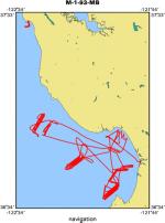
Location map
|
|
|
Bounding Coordinates
|
37.50198
-122.50544 -121.78513
36.61548
|
|
Dates
|
06/01/1993 (JD 152) to 06/14/1993 (JD 165)
|
|
Analog Materials
|
list
|
|
Index map

|
|
|
Crew
|
|
Andy Stevenson
|
Chief Scientist
|
|
Gary Greene
|
Chief Scientist
|
|
Steve Eittreim
|
Watchstander
|
|
Dennis Mann
|
Geophysicist/seismic Watchstander
|
|
John Gann
|
Navigator
|
|
Larry Kooker
|
Electronics Technician
|
|
Mike Boyle
|
Electronics Technician
|
|
|
Equipment Used
|
|
GPS
|
|
sidescansonar
|
|
mudshark
|
|
|
Notes
|
|
|
Publications
|
|
Green, H. Gary, Orange, Daniel, Mann, Dennis, and Gable, Gregg, 1994, Fluid constructed
|
|
morphology on Smooth Ridge, Central California: American Geophysical Union Eos, Transactions,
|
v. 75, no. 44, Supplement, p. 598.
|
|
|
Mann, D.M., Greene, H.G., and Robison, B.H., 1992, Fault deformation of the Monterey Bay
|
|
region, California: American Geophysical Union Eos, Transactions, v. 73, no. 43, Supplement,
|
p. 318.
|
|
|
Got Help?
|
For M-1-93-MB, we would appreciate any information on -- contract, days at sea, dive count, funding, information specialist, information to be derived, kms of navigation, national plan, NGDC Info, organization, owner, ports, project, project number, purpose, scanned materials, seismic description, station count, station description, submersible, summary, tabulated info.
|
|


