|
|
| Cascades Volcano Observatory, Vancouver, Washington |
| Visit A Volcano |

Aerial view of the Inyo Vicinity, Long Valley, California |
| Long Valley Caldera Volcano Information |
 Link to: Long Valley Observatory Website
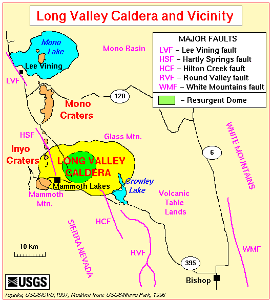
| Long Valley and Vicinity |
|
Long Valley Caldera
About 760,000 years ago a cataclysmic volcanic eruption in the Long Valley, California area blew out 150 cubic miles of magma (molten rock) from a depth of about 4 miles beneath the Earth's surface. Rapidly moving flows of glowing hot ash covered much of east-central California, and airborne ash fell as far east as Nebraska. The Earth's surface sank more than 1 mile into the space once occupied by the erupted magma, forming a large volcanic depression that geologists call a caldera. Today, Long Valley occupies the eastern half of this 10-mile-wide, 20-mile-long caldera. Magma still underlies the caldera and heats underground water. The heated water feeds local hot springs and natural steam vents and drives three geothermal power plants, producing a combined 40 megawatts of electricity. -- Excerpt from: Hill, et.al., 1996, Living With a Restless Caldera -- Long Valley, California: USGS Fact Sheet 196-96
Mammoth Mountain
Mono and Inyo Craters
|
| "Climb A Volcano" |
Just off the north shore of the Mono Lake lies another interesting volcano: Black Point. A low, mesa-like mountain of black ash, Black Point erupted 12,000 years ago following the last ice age, when Mono Lake swelled to five times its current size and nearly ten times its current depth. At that time of its eruption, Black Point was located under water, which probably accounts for its unusual flattened top and the 80' deep, 5' wide cooling fissures that puncture its southwestern face. The hike to the top of Black Point is not an easy one; consider this an exploration, an adventure! There are no trails or signs to show you where to go. You will be walking through the cinders and ash of the volcano and sometimes progress will be difficult. If you persevere, your discovery of the fissures will seem even more spectacular because their remoteness. The fissures cut across the cap of Black Point in a roughly north-south direction. The best route of travel is to meander up the contours, walking south and west. From the high point (benchmark triangle on map), the fissures are to the southwest. Remember, you are hiking at an elevation of nearly 7000 feet. If you come from a lower elevation, you may find the climbing particularly exhausting. Plan to allow ample time to enjoy the walk up (about 45 minutes), to explore the fissures and to return (about 3 hours total). Boots or high topped shoes will increase your comfort by keeping the sand out. Wearing a hat and carrying water are good ideas because you will not find any shade until you reach the fissures. Please watch your step; there are no guard rails or signs. You can help make this experience pleasurable for others by carrying out your trash and by picking up any you find there. Excerpts from: U.S. Forest Service Website, Inyo National Forest, 2001 |
| Location Map |

| Useful Links |
| For More Information |
 California Volcanoes Menu
Return to:
[Visit A Volcano Menu] ...
[California Volcanoes Menu] ...