|
|
|
Great Lakes Regional Sediment Management
|
|

The National Regional Sediment Management Demonstration Program began in FY 2000 and is facilitating the practice of the coastal regional sediment management (RSM) in the U.S. Army Corps of Engineers. RSM refers to the management of littoral, estuarine, and riverine sediment within the boundaries of a physical system where exchange of sediment occurs naturally. A "region" may include a variety of geologic settings, uplands, beaches, inlets, rivers, estuaries, and bays. Implementation of RSM recognizes that the physical system and embedded ecosystems respond beyond the formal dimensions and time frames of individual, local-scale projects. RSM poses all sediment management decisions in the context of all other management actions executed within the region and in the context of all anticipated management actions. RSM increases collaboration and improves decision-making regarding issues of planning, development, damage reduction, and resource management in coastal regions. RSM is intended to provide improved information on environmental, economic and social consequences of proposed actions and a better understanding of potential tradeoffs. RSM results in management plans to guide decisions, actions, and programs, as well as leveraging partner resources. RSM efforts encompass not only geophysical, but also ecological, economic, and institutional components. To successfully conduct RSM, an understanding of regional and local processes is necessary and may require the compilation of sediment budgets, computation of longshore transport rates, and development of comprehensive geographic information systems and data populations. The Great Lakes region has been designated as one of the demonstration sites for the RSM Program. The region being studied is from Ludington, Michigan at the north end, to Michigan City, Indiana at the south. This 172-mile region contains 11 Federal structures, several of which have Section 111 beach nourishment programs in place, and 1 private breakwater. The goals of the Great Lakes demonstration project are: identify key stakeholders who have a role in sediment management for the Southeast Lake Michigan Region; collect available coastal data and develop a centralized web page and GIS database for use by all regional stakeholders; improve current coastal programs and Corps operations and maintenance performance by linking navigation, dredging, disposal, and beach nourishment projects; and, to implement regional sediment management practices for the southeast region of Lake Michigan. These results will have direct ties to the operation of the Section 111 program, the upcoming National Shoreline Management Study, the Lake Michigan Potential Damages Study, and the National Erosion Control Development and Demonstration Program. Additional demonstration sites are planned for the Northern Gulf of Mexico, Northeast Florida, New York/New Jersey, New England, North Carolina/Virginia, the Pacific Northwest, and South California.
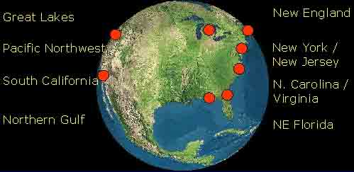
Existing and Potential Demonstration Projects
The Great Lakes Regional Sediment Management Subpages
|
|
|
|
|
|
|
|
|
|
|
|
|


