- Title:
-
Geophysical data of field activity W-14-76-SF in SAN
FRANCISCO 1976 from 00/00/1976 to 00/00/1976
- Abstract:
-
WesternGeco. Geophysical data (navigation, seismic) of field
activity W-14-76-SF in SAN FRANCISCO 1976 from 00/00/1976 to
00/00/1976,
<http://walrus.wr.usgs.gov/infobank/w/w1476sf/html/w-14-76-sf.meta.html>.
- Supplemental_Information:
-
Equipment Used -
navigation data directory exists
seismic data directory exists
Notes -
DESCRIPTION OF SURVEY AREA 114: SAN FRANCISCO 1976<br>
<p>
CLIENT NAME WESTERNGECO MULTICLIENT<br>
COORDINATE LOCATION ANTENNA LOCATIONS<br>
SPHEROID DEFINITION - SURVEYCLARKE (1866) 6378206.400 294.9786985<br>
SPHEROID DEF. - POST PLOT CLARKE (1866) 6378206.400 294.9786985<br>
GEODETIC DATUM - SURVEY NAD 1927<br>
GEODETIC DATUM - POST PLOT NAD 1927<br>
<p>
DATUM SHIFTS<br>
PROJECTION TYPE LAMBERT<br>
GRID SYSTEM CALIFORNIA ZONE 2<br>
GRID UNITS U.S. SURVEY FEET<br>
STANDARD PARALLELS 3820 0.000N 3950 0.000N<br>
CENTRAL MERIDIAN 12200 0.000W<br>
GRID ORIGIN 3720 0.000N12200 0.000W<br>
GRID COORDINATES AT ORIGIN 2000000.00E 0.00N<br>
<p>
Similar information is available for thousands
of other USGS/CMG-related Activities.
If known, available are Activity-specific
navigation, gravity, magnetics, bathymetry,
seismic, and sampling data; track maps; and
equipment information; as well as summary
overviews, crew lists, and information
about analog materials.
If available, access to physical samples is
described in the "WR CMG Sample Distribution
Policy" at:
<http://walrus.wr.usgs.gov/infobank/programs/html/main/sample-dist-policy.html>
Primary access to the USGS/CMG Information
Bank's digital data, analog data, and
metadata is provided through...
<http://walrus.wr.usgs.gov/infobank/>
This page accomodates a variety of search
approaches (e.g., by platform, by region,
by scientist, by equipment type, etc.).
- How should this data set be cited?
U.S. Geological Survey (USGS), Coastal and Marine Geology (CMG), 20081216, Geophysical data of field activity W-14-76-SF in SAN FRANCISCO 1976 from 00/00/1976 to 00/00/1976: U.S. Geological Survey (USGS), Coastal and Marine Geology (CMG).
Online Links:
- What geographic area does the data set cover?
- West_Bounding_Coordinate: -123.53343
- East_Bounding_Coordinate: -121.81741
- North_Bounding_Coordinate: 38.29804
- South_Bounding_Coordinate: 36.68270
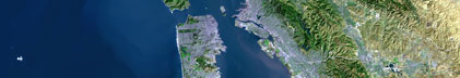
- What does it look like?
- <http://walrus.wr.usgs.gov/infobank/w/w1476sf/html/w-14-76-sf.nav.gif> (GIF)
-
Trackline map of W-14-76-SF
- Does the data set describe conditions during a particular time period?
- Beginning_Date: 1975
- Ending_Date: 1975
- Currentness_Reference: ground condition
- What is the general form of this data set?
- How does the data set represent geographic features?
- How are geographic features stored in the data set?
- Indirect_Spatial_Reference: SAN FRANCISCO 1976
This is a Point data set.
It contains the following vector data types (SDTS terminology):
- What coordinate system is used to represent geographic features?
Horizontal positions are specified in geographic coordinates, that is, latitude and longitude.
Latitudes are given to the nearest 0.00001.
Longitudes are given to the nearest 0.00001.
Latitude and longitude values are specified in Decimal degrees.
The horizontal datum used is North American Datum of 1927.
The ellipsoid used is Clarke 1866.
The semi-major axis of the ellipsoid used is 6378206.4.
The flattening of the ellipsoid used is 1/294.98.
- Vertical_Coordinate_System_Definition:
-
- Depth_System_Definition:
-
- Depth_Datum_Name: Local surface
- Depth_Resolution: 0.1
- Depth_Distance_Units: meters
- Depth_Encoding_Method: Attribute values
- How does the data set describe geographic features?
- Entity_and_Attribute_Overview: Navigation with Time Stamp
- Entity_and_Attribute_Detail_Citation:
-
Integrated navigation (SINS) data
Mnemonic:       (Year, Day, Hour, Min, Sec, Tenths, Latitude, Longitude)
FORTRAN format: (i4.4, i3.3, 3i2.2, i1.1, t16, f9.5, t26, f10.5)
C format:       (%4.4i%3.3i3%2.2i%1.1i %9.5f %10.5f\\n)
Naming:         .050
- Entity_and_Attribute_Overview: Seismic Shots with Time Stamp
- Entity_and_Attribute_Detail_Citation:
-
Edited seismic shot point data
Mnemonic:       (Year, Day, Hour, Min, Sec, Tenths, Line, Shot)
FORTRAN format: (i4.4, i3.3, 3i2.2, i1.1, t16, a5, t22, i5)
C format:       (%4.4i%3.3i3%2.2i%1.1i %5s %5i\\n)
Naming:         .420
- Who are the originators of the data set? (may include formal authors, digital compilers, and editors)
- U.S. Geological Survey (USGS), Coastal and Marine Geology (CMG)
- Who also contributed to the data set?
- To whom should users address questions about the data?
U.S. Geological Survey (USGS), Coastal and Marine Geology (CMG)
c/o Clint Steele
Data Acquisition, Processing, and Storage (DAPS) Group Leader
USGS, MailStop 999, 345 Middlefield Road
Menlo Park, CA 94025-3561
USA
(650) 329-5055 (voice)
(650) 329-5190 (FAX)
csteele@usgs.gov
These data and information are intended for science
researchers, students from elementary through
college, policy makers, and general public.
- From what previous works were the data drawn?
- How were the data generated, processed, and modified?
- Date: 07-Jul-2004 (process 1 of 1)
-
Navigation Data
07/07/2004 clint w-14-76-sf.051
/infobank/programs/time/lines2times/lines2times
Integrated navigation (SINS) data
times are fake

Input was...
year,day,hr,min,sec,tenths,lat,long,line,shot,easting,northing,depth
Person who carried out this activity:
U.S. Geological Survey (USGS), Coastal and Marine Geology (CMG)
c/o Clint Steele
Data Acquisition, Processing, and Storage (DAPS) Group Leader
USGS, MailStop 999, 345 Middlefield Road
Menlo Park, CA 94025-3561
USA
(650) 329-5055 (voice)
(650) 329-5190 (FAX)
csteele@usgs.gov
- What similar or related data should the user be aware of?
U.S. Geological Survey (USGS), Coastal and Marine Geology (CMG), Unknown, USGS/CMG Information Bank: U.S. Geological Survey (USGS), Coastal and Marine Geology (CMG).
Online Links:
- Other_Citation_Details: Updated daily
- How well have the observations been checked?
Identified as best available version.
- How accurate are the geographic locations?
Unspecified
- How accurate are the heights or depths?
Unspecified
- Where are the gaps in the data? What is missing?
Start and end date/times of data
Navigation Data (w-14-76-sf.051 [SINS])
YYYYMMDDHHMMSST    YYYYMMDDHHMMSST
197601010000001    197601010002465
197601020000001    197601020001047
197601030000001    197601030001463
197601040000001    197601040001028
197601050000001    197601050002572
197601060000001    197601060001028
197601070000001    197601070002301
197601080000001    197601080001103
197601090000001    197601090006400
197601100000001    197601100001148
197601110000001    197601110002128
197601120000001    197601120001082
197601130000001    197601130000595
197601140000001    197601140000583
197601150000001    197601150001022
197601160000001    197601160000565
197601170000001    197601170004158
197601180000001    197601180000472
197601190000001    197601190002448
197601200000001    197601200000415
197601210000001    197601210003166
197601220000001    197601220001026
197601230000001    197601230002536
197601240000001    197601240001076
197601250000001    197601250002235
197601260000001    197601260001031
197601270000001    197601270001022
197601280000001    197601280001065
197601290000001    197601290001001
197601300000001    197601300001071
197601310000001    197601310001046
197602010000001    197602010001173
197602020000001    197602020001181
197602030000001    197602030001268
197602040000001    197602040001145
197602050000001    197602050001427
197602060000001    197602060001364
197602070000001    197602070001574
197602080000001    197602080001584
197602090000001    197602090002109
197602100000001    197602100001452
197602110000001    197602110002236
197602120000001    197602120002127
197602130000001    197602130002268
197602140000001    197602140002064
197602150000001    197602150002242
197602160000001    197602160002052
197602170000001    197602170002193
197602180000001    197602180002142
197602190000001    197602190002115
197602200000001    197602200002130
197602210000001    197602210001565
197602220000001    197602220001589
197602230000001    197602230001326
197602240000001    197602240001402
197602250000001    197602250002031
197602260000001    197602260001487
197602270000001    197602270001586
197602280000001    197602280001235
197602290000001    197602290001496
197603010000001    197603010002022
197603020000001    197603020002298
197603030000001    197603030002244
197603040000001    197603040003000
197603050000001    197603050002310
197603060000001    197603060002552
197603070000001    197603070002245
197603080000001    197603080003209
YYYYMMDDHHMMSST    YYYYMMDDHHMMSST
Seismic Shots Data (w-14-76-sf.420_051)
YYYYMMDDHHMMSST    YYYYMMDDHHMMSST
197601010000001    197601010002465
197601020000001    197601020001047
197601030000001    197601030001463
197601040000001    197601040001028
197601050000001    197601050002572
197601060000001    197601060001028
197601070000001    197601070002301
197601080000001    197601080001103
197601090000001    197601090006400
197601100000001    197601100001148
197601110000001    197601110002128
197601120000001    197601120001082
197601130000001    197601130000595
197601140000001    197601140000583
197601150000001    197601150001022
197601160000001    197601160000565
197601170000001    197601170004158
197601180000001    197601180000472
197601190000001    197601190002448
197601200000001    197601200000415
197601210000001    197601210003166
197601220000001    197601220001026
197601230000001    197601230002536
197601240000001    197601240001076
197601250000001    197601250002235
197601260000001    197601260001031
197601270000001    197601270001022
197601280000001    197601280001065
197601290000001    197601290001001
197601300000001    197601300001071
197601310000001    197601310001046
197602010000001    197602010001173
197602020000001    197602020001181
197602030000001    197602030001268
197602040000001    197602040001145
197602050000001    197602050001427
197602060000001    197602060001364
197602070000001    197602070001574
197602080000001    197602080001584
197602090000001    197602090002109
197602100000001    197602100001452
197602110000001    197602110002236
197602120000001    197602120002127
197602130000001    197602130002268
197602140000001    197602140002064
197602150000001    197602150002242
197602160000001    197602160002052
197602170000001    197602170002193
197602180000001    197602180002142
197602190000001    197602190002115
197602200000001    197602200002130
197602210000001    197602210001565
197602220000001    197602220001589
197602230000001    197602230001326
197602240000001    197602240001402
197602250000001    197602250002031
197602260000001    197602260001487
197602270000001    197602270001586
197602280000001    197602280001235
197602290000001    197602290001496
197603010000001    197603010002022
197603020000001    197603020002298
197603030000001    197603030002244
197603040000001    197603040003000
197603050000001    197603050002310
197603060000001    197603060002552
197603070000001    197603070002245
197603080000001    197603080003209
YYYYMMDDHHMMSST    YYYYMMDDHHMMSST
- How consistent are the relationships among the observations, including topology?
Unspecified
Are there legal restrictions on access or use of the data?
- Access_Constraints:
-
Physical materials are under controlled on-site access.
If available, access to physical samples is described
in the "WR CMG Sample Distribution Policy" at:
<http://walrus.wr.usgs.gov/infobank/programs/html/main/sample-dist-policy.html>
- Use_Constraints:
-
Please recognize the U.S. Geological Survey (USGS) as
the source of this information.
Physical materials are under controlled on-site access.
Some USGS information accessed through this means
may be preliminary in nature and presented without
the approval of the Director of the USGS. This
information is provided with the understanding
that it is not guaranteed to be correct or complete
and conclusions drawn from such information are
the responsibility of the user.
This information is not intended for navigational
purposes.
Any use of trade, firm, or product names is for
descriptive purposes only and does not imply
endorsement by the U.S. Government.
- Who distributes the data set? (Distributor 1 of 1)
U.S. Geological Survey (USGS), Coastal and Marine Geology (CMG)
c/o Clint Steele
Data Acquisition, Processing, and Storage (DAPS) Group Leader
USGS, MailStop 999, 345 Middlefield Road
Menlo Park, CA 94025-3561
USA
(650) 329-5055 (voice)
(650) 329-5190 (FAX)
csteele@usgs.gov
- What's the catalog number I need to order this data set?
Downloadable Data W-14-76-SF data set
- What legal disclaimers am I supposed to read?
Please recognize the U.S. Geological Survey (USGS) as
the source of this information.
Physical materials are under controlled on-site access.
Some USGS information accessed through this means
may be preliminary in nature and presented without
the approval of the Director of the USGS. This
information is provided with the understanding
that it is not guaranteed to be correct or complete
and conclusions drawn from such information are
the responsibility of the user.
This information is not intended for navigational
purposes.
Any use of trade, firm, or product names is for
descriptive purposes only and does not imply
endorsement by the U.S. Government.
- How can I download or order the data?
- Availability in digital form:
- Cost to order the data: None
- Dates:
- Last modified: 16-Dec-2008
- Metadata author:
-
U.S. Geological Survey (USGS), Coastal and Marine Geology (CMG)
c/o Clint Steele
Data Acquisition, Processing, and Storage (DAPS) Group Leader
USGS, MailStop 999, 345 Middlefield Road
Menlo Park, CA 94025-3561
USA
(650) 329-5055 (voice)
(650) 329-5190 (FAX)
csteele@usgs.gov
- Metadata standard:
- FGDC Content Standards for Digital Geospatial Metadata (FGDC-STD-001-1998)
Generated by mp version 2.9.2 on Tue Dec 16 05:11:46 2008
|


