 |
11 November 2008
Sensing Our Planet: NASA Earth Science Research Features 2008 now available
+ Read more
|
|
by Stephanie Renfrow
November 11, 2008
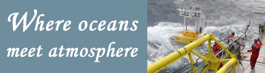
On February 24, 2007, a storm hit the Research Vessel Knorr 1,200 kilometers (650 nautical miles) off the coast of Bermuda. Below decks, the crew listened as the fifty-foot waves and hurricane-force winds slammed into the ship. On the deck, strapped down with fourteen cargo straps, a fifty-foot-long instrument lay awash. Oceanographers aboard the ship had been using the instrument, called a spar buoy, to take measurements in the storm-pounded Northern Atlantic.
Terry Joyce, an oceanographer with the Woods Hole Oceanographic Institution, was aboard the ship during the cruise. He said, "During the night, as we limped toward Bermuda, we took a big wave over the bow and had water up on the bridge. The wave destroyed the spar buoy, which we'd gone to such effort to recover just the day before so it wouldn't get damaged at sea." The wave snapped seven of the cargo straps and swept parts of the buoy overboard; heavy battery cases rolled around on deck threatening to short out and spark a fire. The crew spent much of the night working to secure the mess while the storm continued to toss the ship. "When we got to Bermuda, we realized that there was no way to bring the Humpty Dumpty buoy back to life," he said. "We knew we'd have to write it off and continue the cruise without it."
So why would Joyce join other oceanographers and crew members aboard a ship purposefully bound for the Gulf Stream, an ocean current associated with dangerous winter storms? Joyce was part of a three-year, multi-institutional effort that included fifteen principal investigators, five research cruises, and both satellite and in situ data. The goal: to improve our understanding of Earth's climate by studying the interaction between our planet's ocean currents below and its atmosphere above.
+ Read More |