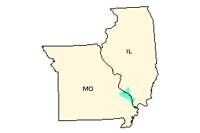
Upper Mississippi-Cape Girardeau Watershed -- 07140105
Upper Mississippi-Cape Girardeau
Watershed Profile
Watershed Name: Upper Mississippi-Cape Girardeau
USGS Cataloging Unit: 07140105
KY 1st Congressional District
MO 3rd Congressional District
MO 8th Congressional District
IL 12th Congressional District
Citizen-based Groups at work in this watershed (Provided by Adopt your Watershed)
Water quality monitoring data from this watershed (Provided by STORET)
Environmental Websites Involving this Watershed
National Watershed Network (provided by Conservation Technology Information Center) ![]()
Assessments of Watershed Health
- Assessed Waters by Watershed
Information provided by the United States Geological Survey (USGS) ![]()
- Stream Flow (Source: USGS)
- Science in Your Watershed
- Water use data (1985-2000): Information about the amount of water used and how it is used.
- Selected USGS Abstracts
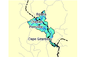
Places Involving this Watershed
-
Counties:
- Alexander
- Jackson
- Perry
- Randolph
- Union
- Bollinger
- Cape Girardeau
- Mississippi
- Perry
- Ste. Genevieve
- St. Francois
- Scott
- None
Visit the Envirofacts Warehouse to retrieve environmental information from EPA databases on Air, Community Water Sources, Water Dischargers, Toxic Releases, Hazardous Waste, and Superfund Sites Geographic searches include zip code, city, EPA Region, or county.