|
|
|
Metadata
|
|
ID
|
M-1-97-WO
|
|
Also Known As
|
AR-5-97
|
|
Abstract
|
United States Geological Survey, Menlo Park, California.
Chief Scientists: Pat McCrory, Dave Twichell. Geophysical
data (GPS, sidescansonar, 3dot5khz, Geopulse, Shipekgrab,
GPS, boomer) of field activity M-1-97-WO in Southwest
Washington Inner Shelf from 07/07/1997 to 07/14/1997
|
|
Organization
|
United States Geological Survey, Menlo Park, California
|
|
Project/Theme
|
Crustal Earthquake Hazards
Southwest Washington Coastal Erosion Study
Coastal Change Hazards
|
|
Chief Scientist
|
Pat McCrory
Dave Twichell
|
|
Activity Type
|
Geophysical
|
|
Platform
|
McArthur
|
|
Area of Operation
|
Southwest Washington Inner Shelf
|
|
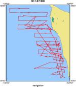
Location map
|
|
|
Bounding Coordinates
|
48.32233
-125.94466 -124.22401
46.91283
|
|
Dates
|
07/07/1997 (JD 188) to 07/14/1997 (JD 195)
|
|
Analog Materials
|
list
|
|
Index map

|
|
|
Information Specialist
|
|
|
Crew
|
|
Pat McCrory
|
Chief Scientist, USGS Western Region
|
|
Dave Foster
|
Computer Analyst, USGS Western Region
|
|
Scott Harrison
|
Computer Analyst, USGS Western Region
|
|
Tom O'Brien
|
Electronics Technician, USGS Woods Hole
|
|
Jim Morris
|
Ship Captain, NOAA
|
|
|
Equipment Used
|
|
GPS
|
|
sidescansonar
|
|
3dot5khz
|
|
Geopulse
|
|
Shipekgrab
|
|
GPS
|
|
boomer
|
|
|
Purpose
|
|
Collect geophysical data to aid in characterizing seismic hazard of nearshore faults & coastal erosion hazard
|
|
|
Information to be Derived
|
|
Seafloor character, late quaternary sediment thickness, shallow (<200 m) faults & folds
|
|
|
Summary
|
|
Collect approx 400 km of high resolution seismic reflection and sidescan sonar data
|
|
|
Got Help?
|
For M-1-97-WO, we would appreciate any information on -- contract, days at sea, dive count, funding, kms of navigation, national plan, NGDC Info, notes, owner, ports, project number, publications, scanned materials, seismic description, station count, station description, submersible, tabulated info.
|
|


