|
! Converted to time format with year at start.
|
|
!
|
|
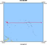
DATA COLLECTION OVERVIEW (use NGDC GEODAS CD to retrieve data)
|
|
|
|
MCG Data Collection ID --- A569NP
|
|
Institution Data Collection ID --- SCAN05AR
|
|
NGDC ID --- 15010062
|
|
Funding --- (unspecified)
|
|
Project, Cruise & Leg --- SCAN LEG 5
|
|
Study region --- +33.00000, +9.00000,+144.00000,-117.00000
|
|
Chief Scientist(s) --- KARIG D.
|
|
Name of vessel --- R/V ARGO (surface ship)
|
|
Date field data collection started --- 07/04/69 APRA,GUAM
|
|
Date field data collection ended --- 08/04/69 SAN DIEGO,CALIFORNIA
|
|
Parameters surveyed ---
|
|
Bathymetry: surveyed, contained in data file
|
|
Magnetics: surveyed, contained in data file
|
|
Gravity: not surveyed
|
|
High-resolution seismics: (unspecified)
|
|
Deep penetration seismics: surveyed, but not contained in data file
|
|
Format --- (I1,A8,F5.2,4I2,F5.3,F8.5,F9.5,I1,F6.4,F6.1,I2,i1,3F6.1,I1,F5.1,F6.0,F7.1,F6.1,F5.1,A8,4I1)
|
|
Date of data input to NGDC --- 08/06/81
|
|
Contributing institution --- SCRIPPS INSTITUTION OF OCEANOGRAPHY
|
|
Country --- USA
|
|
|
|
Navigation instrumentation --- SATNAV,AUTOLOG GYRO AND ENGINE RPM
|
|
Position determination method --- LINEAR INTERP.BETWEEN ADJACENT FIXES
|
|
|
|
Bathymetry instrumentation --- 12KHZ/GIFFT RECORDER/WIDE(60DEG)BEAM
|
|
Additional forms of bathymetric data --- ANALOGUE RECORDS,PUNCHED CARDS
|
|
General rate of bathymetry in file --- 5.0 minutes
|
|
General collection rate of bathymetry --- 1SECONDSWEEP
|
|
Assumed sound velocity --- 1463.0 m/sec
|
|
Bathymetric datum code --- No correction applied (sea level)
|
|
Bathmetry interpolation scheme --- 5 MINUTE INTERVAL
|
|
|
|
Magnetics instrumentation --- VARIAN MFD PROTON PRECESSION MOD 4970
|
|
Additional forms of magnetics data --- ANAL.RECORDS,CARDS
|
|
General rate of magnetics in file --- 6.0 minutes
|
|
General collection rate of magnetics --- 6 seconds
|
|
Magnetic sensor tow distance --- (unspecified)
|
|
Magnetic sensor depth --- (unspecified)
|
|
Two sensor horizontal separation --- (unspecified)
|
|
Residual magnetics reference field --- IGRF-65
|
|
Method of applying residual field --- LIN.INTERP.AT 30DEG C/C OR 500MI ALONG TRACK
|
|
|
|
Seismic instrumentation --- 40CU.IN.AIRGUN,10-300HZ,PDR MK 10 REC.
|
|
Formats of seismic data --- ANAL.RECORDS,35MM MICROFILM
|