|
|
|
Metadata
|
|
ID
|
A-1-04-ME
|
|
Also Known As
|
2004 Maine
|
|
Abstract
|
National Oceanic and Atmospheric Administration. Airborne
Topographic data (LIDAR) of field activity A-1-04-ME in Maine
from 05/05/2004 to 05/05/2004
|
|
Organization
|
National Oceanic and Atmospheric Administration
|
|
Project/Theme
|
Maine Coastline Mapping 2004
|
|
Activity Type
|
Airborne Topographic
|
|
Platform
|
Airplane
|
|
Area of Operation
|
Maine
|
|
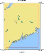
Location map
|
|
|
Bounding Coordinates
|
47.25000
-71.00000 -66.75000
43.25000
|
|
Dates
|
05/05/2004 (JD 126) to 05/05/2004 (JD 126)
|
|
Analog Materials
|
No analog holdings.
|
|
Index map

|
|
|
Information Specialist
|
|
|
Equipment Used
|
|
|
Purpose
|
|
LIDAR data was collected over an area along the coast of Maine to
|
|
support local Coastal Zone Managers in their decision-making processes. Data
|
|
was collected at a nominal two (2) meter post spacing between points. Two
|
|
elevation data sets were compiled in this project; first surface returns, in
|
|
which features that are above the ground - such as buildings, bridges, tree
|
|
tops, etc. - have NOT been eliminated, and a Bare Earth data set.
|
|
|
Notes
|
|
This metadata document describes the collection and processing of
|
|
Light Detection and Ranging (LIDAR) data over an area along the coast of
|
|
Maine. Data was collected at a nominal two (2) meter post spacing between
|
|
points. The elevations in this data set represent the first surface returns.
|
|
Features that are above the ground - such as buildings, bridges, tree tops,
|
|
etc. - have NOT been eliminated.
|
|
|
Got Help?
|
For A-1-04-ME, we would appreciate any information on -- analog materials, chief scientist, contract, crew, days at sea, dive count, funding, information to be derived, kms of navigation, national plan, NGDC Info, owner, ports, project number, publications, scanned materials, seismic description, station count, station description, submersible, summary, tabulated info.
|
|


