|
|
|
Metadata
|
|
ID
|
K-4-73-SC
|
|
Also Known As
|
KEL473SC
|
|
Abstract
|
Chief Scientists: Gary Greene, Holly Wagner. Geophysical
data (uniboom, sparker, bathymetry, magnetics, sidescansonar)
of field activity K-4-73-SC in Carmel Bay to Pt. Sal, Central
California from 11/08/1973 to 11/18/1973
|
|
Chief Scientist
|
Gary Greene
Holly Wagner
|
|
Activity Type
|
Geophysical
|
|
Platform
|
Kelez
|
|
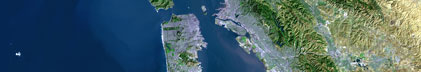
Area of Operation
|
Carmel Bay to Pt. Sal, Central California
|
|
Location map
|
|
|
Bounding Coordinates
|
35.97465
-121.61815 -117.17274
32.36820
|
|
Dates
|
11/08/1973 (JD 312) to 11/18/1973 (JD 322)
|
|
Analog Materials
|
list
|
|
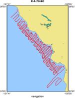
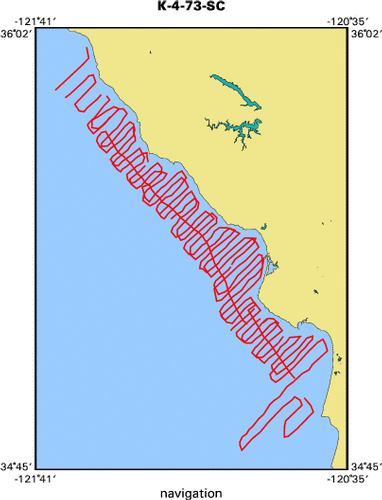
Index map
|
|
|
Crew
|
|
Gary Greene
|
Chief Scientist, USGS Western Region
|
|
Holly Wagner
|
Chief Scientist, USGS Western Region
|
|
Steve Wolf
|
Geologist, USGS Western Region
|
|
|
Equipment Used
|
|
uniboom
|
|
sparker
|
|
bathymetry
|
|
magnetics
|
|
sidescansonar
|
|
|
Purpose
|
|
To obtain detailed geophysical data between Cape San Martin and Pt. Sal
|
|
that would aid in identifying lithologic units and interpreting offshore
|
|
geologic structure for the evaluation of potential hazards, if any, to large
|
|
coastal installations and attendant offshore pipelines. Potential hazards may
|
|
include such features as faults that cut the seafloor, areas of landsliding, and
|
|
submarine slumping.
|
|
|
Information to be Derived
|
|
Approximately 750 mi (1200 km) of deep penetration single channel
|
|
seismic records were obtained using a 120,000 joule sub-bottom acoustic
|
|
reflection profiling system with a 3-second sweep; hight resolution records were
|
|
run simultaneously using an electrical-mechanical system with a 1/4 second
|
|
sweep. Bathymetric data were obtained with a precision depth recorder, magnetic
|
|
data were gathered with a ship-towed magnetometer, and side-scan sonar records
|
|
wers taken locally. The track lines extended 6 to 10 mi from shore and were
|
|
spaced one nautical mile apart throughout most of the area. Because of
|
|
structural complications offshore from the Diablo Canyon site, another 80 mi
|
|
(130 km) of geophysical line was run in that area December 1973, by Geomarine
|
|
Services under contract to the Pacific Gas and Electric Company.
|
|
|
NGDC Overview
|
|
! Converted to time format with year at start.
|
|
!
|
|
DATA COLLECTION OVERVIEW (use NGDC GEODAS CD to retrieve data)
|
|
|
|
MCG Data Collection ID --- K473SC
|
|
Institution Data Collection ID --- K473SC
|
|
NGDC ID --- 06210005
|
|
Funding --- (unspecified)
|
|
Project, Cruise & Leg --- KEL473SC Steve Wolfe Holly Wagner
|
|
Study region --- +36.00000,+32.00000,-122.00000,-117.00000
|
|
Chief Scientist(s) --- Gary Greene
|
|
Name of vessel --- Kelez (surface ship)
|
|
Date field data collection started --- 11/08/73 (unspecified)
|
|
Date field data collection ended --- 12/10/73 (unspecified)
|
|
Parameters surveyed ---
|
|
Bathymetry: (unspecified)
|
|
Magnetics: surveyed, contained in data file
|
|
Gravity: surveyed, contained in data file
|
|
High-resolution seismics: (unspecified)
|
|
Deep penetration seismics: (unspecified)
|
|
Format --- (I1,A8,F5.2,4I2,F5.3,F8.5,F9.5,I1,F6.4,F6.1,I2,i1,3F6.1,I1,F5.1,F6.0,F7.1,F6.1,F5.1,A8,4I1)
|
|
Date of data input to NGDC --- 04/09/87
|
|
Contributing institution --- USGS Branch of Pacific Marine Geology
|
|
Country --- United States
|
|
|
|
Navigation instrumentation --- (unspecified)
|
|
Position determination method --- (unspecified)
|
|
|
|
Bathymetry instrumentation --- (unspecified)
|
|
Additional forms of bathymetric data --- (unspecified)
|
|
General rate of bathymetry in file --- (unspecified)
|
|
General collection rate of bathymetry --- (unspecified)
|
|
Assumed sound velocity --- (unspecified)
|
|
Bathymetric datum code --- No correction applied (sea level)
|
|
Bathmetry interpolation scheme --- (unspecified)
|
|
|
|
Magnetics instrumentation --- (unspecified)
|
|
Additional forms of magnetics data --- (unspecified)
|
|
General rate of magnetics in file --- 2.0 minutes
|
|
General collection rate of magnetics --- (unspecified)
|
|
Magnetic sensor tow distance --- (unspecified)
|
|
Magnetic sensor depth --- (unspecified)
|
|
Two sensor horizontal separation --- (unspecified)
|
|
Residual magnetics reference field --- (unspecified)
|
|
Method of applying residual field --- (unspecified)
|
|
|
|
Gravity instrumentation --- (unspecified)
|
|
Additional forms of gravity data --- (unspecified)
|
|
General rate of gravity in file --- 2.0 minutes
|
|
General collection rate of gravity --- (unspecified)
|
|
Theoretical gravity formula --- (unspecified)
|
|
Reference system --- (unspecified)
|
|
Corrections applied --- (unspecified)
|
|
Starting land tie --- (unspecified)
|
|
Ending land tie --- (unspecified)
|
|
|
|
Seismic instrumentation --- (unspecified)
|
|
Formats of seismic data --- (unspecified)
|
|
|
Publications
|
|
Vedder, J.G., Beyer, L.A., Junger, Arne, Moore, G.W., Roberts, A.E., Taylor, J.C.,
|
|
and Wagner, H.C., 1974, Preliminary report on the geology of the continental borderland
|
|
of Southern California: U.S. Geological Survey Miscellaneous Field Studies Map, MF-0624,
|
p. 34.
|
|
|
Arnal, R.E., and Vedder, J.G., 1976, Changes in Miocene paleobathymetry of California
|
|
continental borderland north of 32 degrees: American Association of Petroleum Geologists
|
|
Bulletin, v. 60, no. 4, American Association of Petroleum Geologists-Society For Sedimentary
|
Geology annual meeting, p. 646.
|
|
|
Arnal, R.E., and Vedder, J.G., 1976, Late Miocene paleobathymetry of California
|
|
continental borderland north of 32 degrees: American Association of Petroleum
|
|
Geologists Bulletin, v. 60, no. 12, American Association of Petroleum Geologists-
|
Society For Sedimentary Geology-SEG Pacific sections meeting, p. 2174.
|
|
|
Vedder, J.G., Taylor, J.C., Arnal, R.E., and Bukry, D., 1976, Map showing location of
|
|
selected pre-Quaternary rock samples from the California continental borderland: U.S.
|
Geological Survey Miscellaneous Field Studies Map MF-737.
|
|
|
Vedder, J.G., and Howell, D.G., 1979, Geologic framework of the southern California borderland: U.S.
|
Geological Survey Professional Paper 1150, p. 146-147.
|
|
|
Vedder, J.G., Crouch, J.K., Scott, E.W., Greene, H.G., Cranmer, D., Ibrahim, M., Tudor, R.B., and
|
|
Vinning, G., 1980, A summary report of the regional geology, petroleum potential, environmental
|
|
geology, and operational considerations in the area of proposed lease sale no. 68, offshore southern
|
California: U.S. Geological Survey Open-File Report 80-198, 64 p.
|
|
|
Campbell, R.H., Wolf, S.C., Hunter, R.E., Wagner, H.C., Junger, Arne, and Vedder, J.G.,
|
|
1975, Geologic map and sections, Santa Barbara Channel region, California: U.S. Geological
|
Survey Open-File Report 75-0123, 1 sheet.
|
|
|
Vedder, J.G., 1990, Maps of California continental borderland showing compositions and ages
|
|
of bottom samples acquired between 1968 and 1979: U.S. Geological Survey Miscellaneous
|
Field Studies Map MF-2122, 3 sheets.
|
|
|
Got Help?
|
For K-4-73-SC, we would appreciate any information on -- contract, days at sea, dive count, funding, information specialist, kms of navigation, national plan, notes, organization, owner, ports, project, project number, scanned materials, seismic description, station count, station description, submersible, summary, tabulated info.
|
|