|
|
|
|
Metadata
|
|
ID
|
P-2-70-SC
|
|
Also Known As
|
PT._HUNEME
|
|
Abstract
|
United States Geological Survey, Menlo Park, California.
Chief Scientist: Gary Greene. Geophysical data (uniboom,
minisparker, sparker, magnetics) of field activity P-2-70-SC
in Pt. Hueneme to Pt. La Jolla, Southern California from
11/20/1970 to 12/05/1970
|
|
Organization
|
United States Geological Survey, Menlo Park, California
|
|
Chief Scientist
|
Gary Greene
|
|
Activity Type
|
Geophysical
|
|
Platform
|
Polaris I
|
|
Area of Operation
|
Pt. Hueneme to Pt. La Jolla, Southern California
|
|
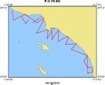
Location map
|
|
|
Bounding Coordinates
|
34.12116
-119.20697 -117.27068
32.83755
|
|
Ports
|
a values
LEAVE Pt. Heuneme, CA
ARRIVE Marina Del Rey, CA
LEAVE Marina Del Rey, CA
ARRIVE San Pedro, CA
LEAVE San Pedro, CA
ARRIVE Newport Beach, CA
LEAVE Newport Beach, CA
ARRIVE Oceanside, CA
LEAVE Oceanside, CA
ARRIVE Oceanside, CA
LEAVE Oceanside, CA
ARRIVE Oceanside, CA
LEAVE Oceanside, CA
ARRIVE Newport Beach, CA
LEAVE Newport Beach, CA
ARRIVE San Pedro, CA
LEAVE San Pedro, CA
ARRIVE Marina Del Rey, CA
|
|
Dates
|
11/20/1970 (JD 324) to 12/05/1970 (JD 339)
|
|
Analog Materials
|
list
|
|
Index map

|
|
|
Crew
|
|
George Moore
|
USGS
|
|
Steve Wolfe
|
USGS
|
|
Robert Patrick
|
USGS
|
|
Ken Blom
|
USGS
|
|
Jerry Joslin
|
|
Frank Lewis
|
|
Bill Olander
|
|
Joe Bauer
|
|
Jim Tomkins
|
Offshore Navigation, Inc.
|
|
John Watkins
|
Offshore Navigation, Inc.
|
|
|
Equipment Used
|
|
uniboom
|
|
minisparker
|
|
sparker
|
|
magnetics
|
|
|
Information to be Derived
|
|
Seismic reflection profiles, bathymetry, magnetics.
|
|
|
Summary
|
|
44 lines were run from Pt. Hueneme to Pt. La Jolla for high resolution
|
|
seismic profiling, bathymetry, sparker, and magnetics. Offshore Navigation Inc.
|
|
made sonobuoy runs.
|
|
|
Publications
|
|
Moore, G.W., 1975, Acoustic reflection profiles R/V Polaris, Nov.-Dec. 1970,
|
|
Offshore Southern California Port Hueneme to Point La Jolla: U.S Geological
|
|
Survey Report 75-629.
|
|
|
Got Help?
|
For P-2-70-SC, we would appreciate any information on -- contract, days at sea, dive count, funding, information specialist, kms of navigation, national plan, NGDC Info, notes, owner, project, project number, purpose, scanned materials, seismic description, station count, station description, submersible, tabulated info.
|
|