|
|
|
Metadata
|
|
ID
|
S-5A-79-NC
|
|
Also Known As
|
REX_1
|
|
Abstract
|
Chief Scientists: Dave Cacchione, Dave Drake. Geophysical
data (12khz, 3dot5khz, uniboom, Geoprobe, underwatercamera,
underwatertelevision, CTDmeter, Aanderaa, Geodyne,
nephelometer, dartcore, VanVeengrab, VanDornbottle,
sidescanmarker) of field activity S-5A-79-NC in Northern
California from 05/30/1979 to 06/03/1979
|
|
Chief Scientist
|
Dave Cacchione
Dave Drake
|
|
Activity Type
|
Geophysical
|
|
Platform
|
Sea Sounder
|
|
Area of Operation
|
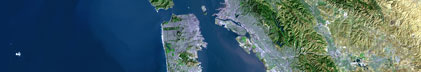
Northern California
|
|
Location map
|
|
|
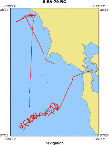
Bounding Coordinates
|
38.46464
-123.45180 -122.36410
37.15389
|
|
Ports
|
leave Redwood City, CA
arrive Treasure Island, CA
|
|
Dates
|
05/30/1979 (JD 150) to 06/03/1979 (JD 154)
|
|
Analog Materials
|
list
|
|
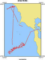
Index map
|
|
|
Crew
|
|
Mike Boyle
|
Electronics Technician, USGS Western Region
|
|
Dave Cacchione
|
Chief Scientist, USGS Western Region
|
|
Scott Conard
|
Chief Engineer, USGS Western Region
|
|
Dave Drake
|
Chief Scientist, USGS Western Region
|
|
Steve Eittreim
|
Geologist, USGS Western Region
|
|
Margaret Goud
|
Navigator, USGS Western Region
|
|
Frank Johnson
|
Chief Mate
|
|
Jack Lee
|
Electronics Technician, USGS Western Region
|
|
Paula Mackrow
|
Navigator
|
|
Jim Nicholson
|
Electronics Technician, USGS Western Region
|
|
Kevin O'Toole
|
Mechanical Technician, USGS Western Region
|
|
Frank Sherer
|
Ship Captain
|
|
Gary Sullivan
|
Geologist
|
|
George Tate
|
Geologist and Watchstander, USGS Western Region
|
|
Jan Thompson
|
Biologist
|
|
Chuck Totman
|
Geologist, USGS Western Region
|
|
Pat Wiberg
|
Navigator, USGS Western Region
|
|
Bob Wilson
|
Mechanical Technician, USGS Western Region
|
|
|
Equipment Used
|
|
12khz
|
|
3dot5khz
|
|
uniboom
|
|
Geoprobe
|
|
underwatercamera
|
|
underwatertelevision
|
|
CTDmeter
|
|
Aanderaa
|
|
Geodyne
|
|
nephelometer
|
|
dartcore
|
|
VanVeengrab
|
|
VanDornbottle
|
|
sidescanmarker
|
|
|
NGDC Overview
|
|
! Converted to time format with year at start.
|
|
!
|
|
DATA COLLECTION OVERVIEW (use NGDC GEODAS CD to retrieve data)
|
|
|
|
MCG Data Collection ID --- S5A79NC
|
|
Institution Data Collection ID --- S5A79NC
|
|
NGDC ID --- 06110034
|
|
Funding --- (unspecified)
|
|
Project, Cruise & Leg --- S5a79SC Dave Drake
|
|
Study region --- +39.00000,+37.00000,-124.00000,-122.00000
|
|
Chief Scientist(s) --- Dave Cacchione
|
|
Name of vessel --- Sea Sounder (surface ship)
|
|
Date field data collection started --- 05/29/79 LV REDWOOD CITY
|
|
Date field data collection ended --- 06/03/79 AR TREASURE ISLAND
|
|
Parameters surveyed ---
|
|
Bathymetry: surveyed, contained in data file
|
|
Magnetics: (unspecified)
|
|
Gravity: (unspecified)
|
|
High-resolution seismics: (unspecified)
|
|
Deep penetration seismics: (unspecified)
|
|
Format --- (I1,A8,F5.2,4I2,F5.3,F8.5,F9.5,I1,F6.4,F6.1,I2,i1,3F6.1,I1,F5.1,F6.0,F7.1,F6.1,F5.1,A8,4I1)
|
|
Date of data input to NGDC --- 11/30/90
|
|
Contributing institution --- USGS Branch of Pacific Marine Geology
|
|
Country --- United States
|
|
|
|
Navigation instrumentation --- (unspecified)
|
|
Position determination method --- (unspecified)
|
|
|
|
Bathymetry instrumentation --- (unspecified)
|
|
Additional forms of bathymetric data --- (unspecified)
|
|
General rate of bathymetry in file --- 1.3 minutes
|
|
General collection rate of bathymetry --- (unspecified)
|
|
Assumed sound velocity --- 1463.0 m/sec
|
|
Bathymetric datum code --- No correction applied (sea level)
|
|
Bathmetry interpolation scheme --- (unspecified)
|
|
|
|
Magnetics instrumentation --- (unspecified)
|
|
Additional forms of magnetics data --- (unspecified)
|
|
General rate of magnetics in file --- (unspecified)
|
|
General collection rate of magnetics --- (unspecified)
|
|
Magnetic sensor tow distance --- (unspecified)
|
|
Magnetic sensor depth --- (unspecified)
|
|
Two sensor horizontal separation --- (unspecified)
|
|
Residual magnetics reference field --- (unspecified)
|
|
Method of applying residual field --- (unspecified)
|
|
|
|
Gravity instrumentation --- (unspecified)
|
|
Additional forms of gravity data --- (unspecified)
|
|
General rate of gravity in file --- (unspecified)
|
|
General collection rate of gravity --- (unspecified)
|
|
Theoretical gravity formula --- (unspecified)
|
|
Reference system --- (unspecified)
|
|
Corrections applied --- (unspecified)
|
|
Starting land tie --- (unspecified)
|
|
Ending land tie --- (unspecified)
|
|
|
|
Seismic instrumentation --- (unspecified)
|
|
Formats of seismic data --- (unspecified)
|
|
|
Publications
|
|
Reid, J.A., Reid, J.M., Jenkins, C.J., Zimmermann, M., Williams, S.J., and
|
|
Field, M.E., 2006, usSEABED: Pacific Coast (California, Oregon, Washington)
|
|
offshore surficial-sediment data release, U.S. Geological Survey Data Series
|
|
182, version 1.0. Online at:
|
|
|
http://pubs.usgs.gov/ds/2006/182/
|
|
|
Got Help?
|
For S-5A-79-NC, we would appreciate any information on -- contract, days at sea, dive count, funding, information specialist, information to be derived, kms of navigation, national plan, notes, organization, owner, project, project number, purpose, scanned materials, seismic description, station count, station description, submersible, summary, tabulated info.
|
|