|
|
|
Metadata
|
|
ID
|
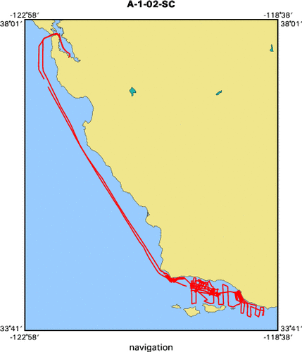
A-1-02-SC
|
|
Also Known As
|
A1-02-SC
|
|
Abstract
|
United States Geological Survey, Menlo Park, California.
Chief Scientists: Mike Fisher, Chris Gutmacher. Geophysical
data (12khz, YoNav, GPS, Kleinsidescan, airgun, minisparker,
Chirp, boomer, sparker) of field activity A-1-02-SC in Pt.
Arguello to Pt. Dume from 06/14/2002 to 06/29/2002
|
|
Organization
|
United States Geological Survey, Menlo Park, California
|
|
Project/Theme
|
Southern California Continental Borderland
|
|
Chief Scientist
|
Mike Fisher
Chris Gutmacher
|
|
Activity Type
|
Geophysical
|
|
Platform
|
Auriga
|
|
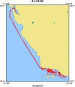
Area of Operation
|
Pt. Arguello to Pt. Dume
|
|
Location map
|
|
|
Bounding Coordinates
|
37.83305
-122.72889 -118.87541
33.89323
|
|
Ports
|
leave Redwood City, CA
arrive Redwood City, CA
|
|
Dates
|
06/14/2002 (JD 165) to 06/29/2002 (JD 180)
|
|
Analog Materials
|
list
|
|
Index map
|
|
|
Information Specialist
|
|
|
Crew
|
|
Mike Fisher
|
Chief scientist, USGS Menlo Park, CA
|
|
Chris Gutmacher
|
Assistant chief scientist, USGS Menlo Park, CA
|
|
Beth Feingold
|
Navigation, USGS Menlo Park, CA
|
|
Lori Hibbeler
|
Navigation, USGS Menlo Park, CA
|
|
Jane Reid
|
Data Acquisition, USGS Menlo Park, CA
|
|
Ray Sliter
|
Data Acquisition, USGS Menlo Park, CA
|
|
Kevin O'Toole
|
MT, USGS Menlo Park, CA
|
|
Mike Boyle
|
ET, USGS Menlo Park, CA
|
|
Larry Kooker
|
ET, USGS Menlo Park, CA
|
|
Mike Belliveau
|
Huntec support, Geoforce Consultants, Nova Scotia
|
|
Todd Chandler
|
Mammal observation chief, Cascadia Research, Olympia, WA
|
|
Randy Lumper
|
Mammal observation, Cascadia Research, Olympia, WA
|
|
Laura Maycollado
|
Mammal observation, Cascadia Research, Olympia, WA
|
|
Beth Phillips
|
Mammal observation, Cascadia Research, Olympia, WA
|
|
Christina Tombach
|
Mammal observation, Cascadia Research, Olympia, WA
|
|
Ken Robinson
|
Captain Auriga, F/V Northwind Inc., Seattle, WA
|
|
Kevin Blakley
|
First Mate, F/V Northwind Inc., Seattle, WA
|
|
Jamie Lauritzen
|
Second Mate, F/V Northwind Inc., Seattle, WA
|
|
Mike Horton
|
Chief Engineer, F/V Northwind Inc., Seattle, WA
|
|
Mike Henderson
|
Engineer, F/V Northwind Inc., Seattle, WA
|
|
Modu Ndiaye
|
Chef, not just cook!, F/V Northwind Inc., Seattle, WA
|
|
|
Equipment Used
|
|
12khz
|
|
YoNav
|
|
GPS
|
|
Kleinsidescan
|
|
airgun
|
|
minisparker
|
|
Chirp
|
|
boomer
|
|
sparker
|
|
|
Purpose
|
|
2 part: sidescan survey for Marine Minerals Service near Pts. Arguello and Conception.
|
|
Geophysical survey to expand mapping of offshore faults in Santa Barbara Channel from Gaviota to Pt. Dume.
|
|
|
Information to be Derived
|
|
Sidescan mosaic and interpreted locations of natural gas seeps.
|
|
Fault map and target locations for future cores to determine age of fault movement.
|
|
|
Summary
|
|
Sidescan survey completed. Geophysical survey hampered by high winds and equipment problems; nonetheless some excellent data were acquired.
|
|
|
Publications
|
|
Normark, William R., Fisher, Michael A., Gutmacher,
|
|
Christina E., Sliter, Ray, Hibbeler, Lori Feingold, Beth, and Reid, Jane,
|
|
2003, Cruise report for A1-02-SC Southern California CABRILLO project,
|
earthquake hazards task: U.S. Geological Survey Open-File Report 03-110:
|
|
HREF="http://geopubs.wr.usgs.gov/open-file/of03-110">walrus.wr.usgs.gov/reports
|
of03-110
|
|
|
Got Help?
|
For A-1-02-SC, we would appreciate any information on -- contract, days at sea, dive count, funding, kms of navigation, national plan, NGDC Info, notes, owner, project number, scanned materials, seismic description, station count, station description, submersible, tabulated info.
|
|