|
|
|
Metadata
|
|
ID
|
P-2-95-MB
|
|
Abstract
|
Chief Scientists: Brian Edwards, Homa Lee. Geological data
(multicore, boxcore, 3dot5khz, underwatercamera, GPS, YoNav,
12khz, Shipekgrab, VanVeengrab, Soutargrab, clamshellgrab) of
field activity P-2-95-MB in Monterey Bay, California from
09/06/1995 to 09/12/1995
|
|
Project/Theme
|
Monterey Bay National Marine Sanctuary
|
|
National Plan
|
Marine Reserves And Biologic Habitats
|
|
Chief Scientist
|
Brian Edwards
Homa Lee
|
|
Activity Type
|
Geological
|
|
Platform
|
Point Sur
|
|
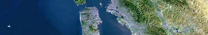
Area of Operation
|
Monterey Bay, California
|
|
Location map
|
|
|
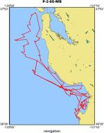
Bounding Coordinates
|
37.81730
-122.91592 -121.78502
36.53107
|
|
Dates
|
09/06/1995 (JD 249) to 09/12/1995 (JD 255)
|
|
Analog Materials
|
list
|
|
Index map

|
|
|
Crew
|
|
Steve Bliss
|
Ship Captain
|
|
John Klusmire
|
Chief Mate
|
|
Bob Winton
|
Chief Engineer
|
|
Brian Edwards
|
Chief Scientist, USGS Western Region
|
|
Homa Lee
|
Chief Scientist, USGS Western Region
|
|
Andrew Devagles
|
Unspecified Investigator, NOAA
|
|
Walt Olson
|
Mechanical Technician, USGS Western Region
|
|
Rich Mueller
|
Mechanical Technician, MLML
|
|
Kaye Kinoshita
|
Navigator, USGS Western Region
|
|
Melanie Moreno
|
Geologist, USGS Western Region
|
|
Pete Dartnell
|
Geologist, USGS Western Region
|
|
Hank Chezar
|
Photographer, USGS Western Region
|
|
Kevin Evans
|
Geologist, USGS Western Region
|
|
Michelle White
|
Biologist, MLML
|
|
Amy Wagner
|
Biologist, EPA
|
|
Stewart Lamerdin
|
Biologist, CDFG
|
|
|
Equipment Used
|
|
multicore
|
|
boxcore
|
|
3dot5khz
|
|
underwatercamera
|
|
GPS
|
|
YoNav
|
|
12khz
|
|
Shipekgrab
|
|
VanVeengrab
|
|
Soutargrab
|
|
clamshellgrab
|
|
|
Purpose
|
|
Conduct bottom sampling within the Monterey
|
|
Bay National Marine Sanctuary from Carmel to the Golden Gate.
|
|
|
Publications
|
|
Reid, J.A., Reid, J.M., Jenkins, C.J., Zimmermann, M., Williams, S.J., and
|
|
Field, M.E., 2006, usSEABED: Pacific Coast (California, Oregon, Washington)
|
|
offshore surficial-sediment data release, U.S. Geological Survey Data Series
|
|
182, version 1.0. Online at:
|
|
|
http://pubs.usgs.gov/ds/2006/182/
|
|
|
Edwards, B.D., and Chezar, Henry, 1996, Camera survey of effluent-affected sediment on the
|
|
continental margin near Los Angeles, California: American Geophysical Union Eos, Transactions,
|
v. 77, no. 3, Supplement, p. 50.
|
|
|
Orzech, K.M., Dahl, W.E., and Edwards, B.D., 2001, Core Descriptions,
|
|
Core Photographs, Physical Property Logs and Surface Textural Data of
|
|
Sediment Cores Recovered from the Continental Shelf of the Monterey Bay
|
|
National Marine Sanctuary During Research Cruises M-1-95-MB, P-2-95-MB,
|
|
and P-1-97-MB, US Geological Survey
|
Openfile report 01-107:
http://geopubs.wr.usgs.gov/open-file/of01-107/
|
|
|
|
Eittreim, Stephen L., and Noble, Marlene, editors, 2002, Seafloor geology and
|
|
natural environment of the Monterey Bay National Marine Sanctuary: Marine Geology, v
|
|
. 181
|
|
http://www.sciencedirect.com/
|
|
|
Journals > m > Marine Geology > Volumes 181 - 190 > Volume 181, Issues 1-3
|
|
|
|
Wong, F.L., and Eittreim, S.L., 2001, Continental Shelf GIS for the Monterey
|
|
Bay National Marine Sanctuary: U.S. Geological Survey Open-file Report 01-179,
|
|
1 CDROM,
|
|
http://geopubs.wr.usgs.gov/
|
open-file/of01-179/
|
|
|
Got Help?
|
For P-2-95-MB, we would appreciate any information on -- contract, days at sea, dive count, funding, information specialist, information to be derived, kms of navigation, NGDC Info, notes, organization, owner, ports, project number, scanned materials, seismic description, station count, station description, submersible, summary, tabulated info.
|
|