Link to USGS home page
USGS Home
Contact USGS
Search USGS
Coastal & Marine Geology InfoBank

USGS CMG L-4-77-NC Metadata

Skip navigational links
Search InfoBank
Home tab FACS tab Activities tab Atlas tab Geology School tab More tab More tab Activities tabs
   
Activities: by ID   by Platform   by Year   by Region   by Participant   by Organization   by Project/Theme   with Incomplete IDs   Disclaimer  
Activity First Letter: A   B   C   D   E   F   G   H   I   J   K   L   M   N   O   P   Q   R   S   T   U   V   W   X   Y   Z   0   1   2   3   4   5   6   7   8   9  
Virtual Globes: Atlas  (GE)    Samples  (GE)    Illuminate Oceans  (GE)    Earthquakes  (GE)    Get GE    InfoBank examples    State Waters
L-4-77-NC links...
Metadata & Data: Bathymetry   Gravity   Magnetics   Metadata   Navigation   Seismic   bath (GE GM)   grav (GE GM)   mag (GE GM)   nav (GE GM)   seis (GE GM)   times (GE GM)  
Formal Metadata: Frequently-Anticipated Questions   Outline   Parseable Text   XML  
   
   
Metadata
ID L-4-77-NC
Abstract Chief Scientist: Dave McCulloch. Geophysical data (LoranC, dopplersonar, 12khz, magnetics, Burgairgun, gradiometer, gravity, airgun, 24channel, 3dot5khz, integratednavigation, uniboom, airgunmonitor) of field activity L-4-77-NC in Northern California from 05/10/1977 to 05/21/1977
Chief Scientist Dave McCulloch
Activity Type Geophysical
Platform Samuel Phillips Lee
Area of Operation
Northern California
Location map L-4-77-NC location map of where navigation equipment operated
Bounding Coordinates 42.73476
-125.91021    -122.97494
37.70722
Ports leave Redwood City, CA
arrive Coos Bay, OR
Dates 05/10/1977 (JD 130) to 05/21/1977 (JD 141)
Analog Materials list
Index map

L-4-77-NC map of where navigation equipment operated

Crew
Al Goodman Watchstander
Alan Long Watchstander
Art Conradi Watchstander
Cheryl Price Watchstander
Chris Gutmacher Dafe Curator
Curtis Thompson Chief Mate
Dave McCulloch Chief Scientist
Dave Rubin Watchstander
Dave Wilson Watchstander
Dennis Mann Watchstander
Gary Younse Watchstander
George Asuncion Electronics Technician
Glen Barker Mechanical Technician
Henry Cullins Watchstander
John Simpson Chief Engineer
Jon Erickson Mechanical Technician
Karen Bachmann Watchstander
Mary Spilker Watchstander
Steve Davenport Watchstander
Terry Kelley Electronics Technician
W. T. Ruff Ship Captain
Equipment Used
LoranC
dopplersonar
12khz
magnetics
Burgairgun
gradiometer
gravity
airgun
24channel
3dot5khz
integratednavigation
uniboom
airgunmonitor
NGDC Overview
! Converted to time format with year at start.
!
DATA COLLECTION OVERVIEW (use NGDC GEODAS CD to retrieve data)
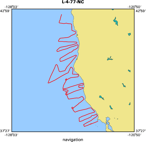
MCG Data Collection ID --- L477NC
Institution Data Collection ID --- L477NC
NGDC ID --- 06050013
Funding --- (unspecified)
Project, Cruise & Leg --- (unspecified)
Study region --- +43.00000,+37.00000,-126.00000,-122.00000
Chief Scientist(s) --- Dave McCulloch
Name of vessel --- Lee (surface ship)
Date field data collection started --- 05/10/77 LV REDWOOD CITY CA
Date field data collection ended --- 05/21/77 AR COOS BAY, OREGON
Parameters surveyed ---
Bathymetry: (unspecified)
Magnetics: surveyed, contained in data file
Gravity: (unspecified)
High-resolution seismics: (unspecified)
Deep penetration seismics: surveyed, contained in data file
Format --- (I1,A8,F5.2,4I2,F5.3,F8.5,F9.5,I1,F6.4,F6.1,I2,i1,3F6.1,I1,F5.1,F6.0,F7.1,F6.1,F5.1,A8,4I1)
Date of data input to NGDC --- 05/21/87
Contributing institution --- USGS Branch of Pacific Marine Geology
Country --- United States
Navigation instrumentation --- LORAN C,DOPLER SON,MARCO
Position determination method --- (unspecified)
Bathymetry instrumentation --- 12 KHZ DIGITIZED BATHY 3.5 KHZ BATHYMETR
Additional forms of bathymetric data --- Y
General rate of bathymetry in file --- (unspecified)
General collection rate of bathymetry --- (unspecified)
Assumed sound velocity --- (unspecified)
Bathymetric datum code --- No correction applied (sea level)
Bathmetry interpolation scheme --- (unspecified)
Magnetics instrumentation --- MAGNETICS -TAPES & ROLLS
Additional forms of magnetics data --- (unspecified)
General rate of magnetics in file --- 1.0 minutes
General collection rate of magnetics --- (unspecified)
Magnetic sensor tow distance --- (unspecified)
Magnetic sensor depth --- (unspecified)
Two sensor horizontal separation --- (unspecified)
Residual magnetics reference field --- (unspecified)
Method of applying residual field --- (unspecified)
Gravity instrumentation --- BURG PROCESSOR
Additional forms of gravity data --- (unspecified)
General rate of gravity in file --- (unspecified)
General collection rate of gravity --- (unspecified)
Theoretical gravity formula --- (unspecified)
Reference system --- (unspecified)
Corrections applied --- (unspecified)
Starting land tie --- (unspecified)
Ending land tie --- (unspecified)
Seismic instrumentation --- SINGLE CHANNEL AIRGUN 24 CHANNEL SEISMIC
Formats of seismic data --- (unspecified)
Publications
McCulloch, David S., Mann, Dennis M., Ryan, Holly F., and Sliter, Ray W., 1986, Multichannel
seismic-reflection profiles collected in 1977 off the Northern California and Oregon coast:
U.S. Geological Survey Open-File Report 86-0406, 4 p., 1 sheet.
Got Help? For L-4-77-NC, we would appreciate any information on -- contract, days at sea, dive count, funding, information specialist, information to be derived, kms of navigation, national plan, notes, organization, owner, project, project number, purpose, scanned materials, seismic description, station count, station description, submersible, summary, tabulated info.


Skip footer navigational links


InfoBank   Menlo Park & Santa Cruz Centers   St. Petersburg Center   Woods Hole Center   Coastal and Marine Geology Program   Geologic Information   Ask-A-Geologist   USGS Disclaimer  

FirstGov button   Take Pride in America button