- Identification_Information:
-
- Citation:
-
- Citation_Information:
-
- Originator: U.S. Geological Survey (USGS), Coastal and Marine Geology (CMG)
- Publication_Date: 20081216
- Title:
-
High-Resolution Seismic data of field activity M-4-97-MB in
Monterey Bay Sanctuary from 09/09/1997 to 09/17/1997
- Publication_Information:
-
- Publisher: U.S. Geological Survey (USGS), Coastal and Marine Geology (CMG)
- Online_Linkage: <http://walrus.wr.usgs.gov/infobank/gos/m-4-97-mb.fmeta.xml>
- Online_Linkage:
-
<http://walrus.wr.usgs.gov/infobank/m/m497mb/html/m-4-97-mb.meta.html>
- Description:
-
- Abstract:
-
Chief Scientists: Brian Edwards, Roberto Anima.
High-Resolution Seismic data (Huntec, 3dot5khz, GPS, YoNav,
mudseis, bathymetry, integratednavigation, boomer) of field
activity M-4-97-MB in Monterey Bay Sanctuary from 09/09/1997
to 09/17/1997,
<http://walrus.wr.usgs.gov/infobank/m/m497mb/html/m-4-97-mb.meta.html>.
- Purpose:
-
These data and information are intended for science
researchers, students from elementary through
college, policy makers, and general public.
- Supplemental_Information:
-
Equipment Used -
Huntec Geoforce Huntec
3dot5khz 3.5 khz odec
GPS differential GPS
YoNav
mudseis
bathymetry
integratednavigation
boomer
Notes -
In early September, the Monterey Bay National Marine Sanctuary
(MBNMS) project conducted a very successful 10-day cruise on the
continental shelf between Carmel and the Golden Gate. The cruise was
a very high resolution seismic-reflection cruise aboard the NOAA ship
McArthur. The geophysical leg was designed to delineate the three-
dimensional spatial distribution of areas of sediment erosion,
deposition, bypass, and outcrops within this shelf region. We
used the newly remodeled HUNTEC system to collect approximately
1400 trackline-km of very high resolution boomer data (centered in
the 2-kHz to 2.5-kHz range). The system performed beautifully and
provided high-quality data, at times to subbottom depths exceeding
100 m.
Roberto Anima was co-chief, and Kaye Kinoshita, Rebecca Preston,
and Glenn Spinelli provided support during the geophysical work.
We conducted the cruise at a time when MARFAC was hard pressed with
the BASIX III operation. Fred Payne, Mike Boyle, and Graham Standen
(GEOFORCE tech) got to play with the HUNTEC system during the
geophysical leg. I thank MARFAC and particularly Fred and Mike for
their help in making the cruise successful. (Paraphrased from
Brian Edwards's "CRUISE SUMMARY: MBNMS PROJECT", Western Region
Coastal and Marine Geology Bulletin, November 7, 1997.)
Publications -
Eittreim, Stephen L., and Noble, Marlene, editors, 2002, Seafloor geology and
natural environment of the Monterey Bay National Marine Sanctuary: Marine Geology, v
. 181
<A HREF="<http://www.sciencedirect.com/>"><http://www.sciencedirect.com/>
</A><BR>
Journals > m > Marine Geology > Volumes 181 - 190 > Volume 181, Issues 1-3
<BR>
<HR>
Wong, F.L., and Eittreim, S.L., 2001, Continental Shelf GIS for the Monterey
Bay National Marine Sanctuary: U.S. Geological Survey Open-file Report 01-179,
1 CDROM,
<A HREF="<http://geopubs.wr.usgs.gov/open-file/of01-179/>"><http://geopubs.wr.usgs.gov/>
open-file/of01-179/</A><BR>
Similar information is available for thousands
of other USGS/CMG-related Activities.
If known, available are Activity-specific
navigation, gravity, magnetics, bathymetry,
seismic, and sampling data; track maps; and
equipment information; as well as summary
overviews, crew lists, and information
about analog materials.
If available, access to physical samples is
described in the "WR CMG Sample Distribution
Policy" at:
<http://walrus.wr.usgs.gov/infobank/programs/html/main/sample-dist-policy.html>
Primary access to the USGS/CMG Information
Bank's digital data, analog data, and
metadata is provided through...
<http://walrus.wr.usgs.gov/infobank/>
This page accomodates a variety of search
approaches (e.g., by platform, by region,
by scientist, by equipment type, etc.).
- Time_Period_of_Content:
-
- Time_Period_Information:
-
- Range_of_Dates/Times:
-
- Beginning_Date: 19970909
- Ending_Date: 19970917
- Currentness_Reference: ground condition
- Status:
-
- Progress: Complete
- Maintenance_and_Update_Frequency: As needed
- Spatial_Domain:
-
- Bounding_Coordinates:
-
- West_Bounding_Coordinate: -122.94837
- East_Bounding_Coordinate: -121.82364
- North_Bounding_Coordinate: 37.83167
- South_Bounding_Coordinate: 36.63868
- Keywords:
-
- Theme:
-
- Theme_Keyword_Thesaurus: ISO 19115 Topic Category
- Theme_Keyword: geoscientificinformation
- Theme_Keyword: oceans
- Theme:
-
- Theme_Keyword_Thesaurus: USGS CMG InfoBank
- Theme_Keyword: Marine Geology
- Theme_Keyword: Marine Geophysics
- Theme_Keyword: Bathymetry
- Theme_Keyword: Water Depth
- Theme_Keyword: Seafloor Topography
- Theme_Keyword: Marine Seismic
- Place:
-
- Place_Keyword_Thesaurus: USGS CMG InfoBank
- Place_Keyword: CA
- Place_Keyword: Monterey Bay
- Place_Keyword: Monterey Bay National Marine Sanctuary, CA
- Place_Keyword: Monterey Bay Sanctuary
- Place_Keyword: Monterey Bay, CA
- Place_Keyword: North Pacific Ocean
- Place_Keyword: Northern California
- Place_Keyword: Northern Pacific Ocean
- Place_Keyword: USA
- Access_Constraints:
-
Physical materials are under controlled on-site access.
If available, access to physical samples is described
in the "WR CMG Sample Distribution Policy" at:
<http://walrus.wr.usgs.gov/infobank/programs/html/main/sample-dist-policy.html>
- Use_Constraints:
-
Please recognize the U.S. Geological Survey (USGS) as
the source of this information.
Physical materials are under controlled on-site access.
Some USGS information accessed through this means
may be preliminary in nature and presented without
the approval of the Director of the USGS. This
information is provided with the understanding
that it is not guaranteed to be correct or complete
and conclusions drawn from such information are
the responsibility of the user.
This information is not intended for navigational
purposes.
Any use of trade, firm, or product names is for
descriptive purposes only and does not imply
endorsement by the U.S. Government.
- Point_of_Contact:
-
- Contact_Information:
-
- Contact_Organization_Primary:
-
- Contact_Organization: U.S. Geological Survey (USGS), Coastal and Marine Geology (CMG)
- Contact_Person: Clint Steele
- Contact_Position: Data Acquisition, Processing, and Storage (DAPS) Group Leader
- Contact_Address:
-
- Address_Type: mailing and physical address
- Address: USGS, MailStop 999, 345 Middlefield Road
- City: Menlo Park
- State_or_Province: CA
- Postal_Code: 94025-3561
- Country: USA
- Contact_Voice_Telephone: (650) 329-5055
- Contact_Facsimile_Telephone: (650) 329-5190
- Contact_Electronic_Mail_Address: csteele@usgs.gov
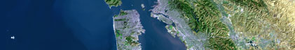
- Browse_Graphic:
-
- Browse_Graphic_File_Name:
-
<http://walrus.wr.usgs.gov/infobank/m/m497mb/html/m-4-97-mb.nav.gif>
- Browse_Graphic_File_Description: Trackline map of M-4-97-MB
- Browse_Graphic_File_Type: GIF
- Data_Set_Credit:
-
Bill Siles (Ship Captain);
Duanne Timmons (Executive Officer);
Dana Wilkes (Field Ops Officer);
Brian Edwards (Chief Scientist, USGS Western Region);
Roberto Anima (Chief Scientist, USGS Western Region);
Fred Payne (Electronics Technician, USGS Western Region);
Mike Boyle (Electronics Technician, USGS Western Region);
Rebeca Preston (Geologist);
Glen Spinelli (Geologist);
Don Reed (Geologist, San Jose State University);
Kaye Kinoshita (Navigator, USGS Western Region);
Michelle Jacobi (Unspecified Investigator, NOAA);
Melli Lewis (Unspecified Investigator, NOAA);
Graham Standen (Unspecified Investigator, Geoforce)
- Native_Data_Set_Environment: Digital, ASCII
- Cross_Reference:
-
- Citation_Information:
-
- Originator: U.S. Geological Survey (USGS), Coastal and Marine Geology (CMG)
- Publication_Date: Unknown
- Title: USGS/CMG Information Bank
- Publication_Information:
-
- Publisher: U.S. Geological Survey (USGS), Coastal and Marine Geology (CMG)
- Other_Citation_Details: Updated daily
- Online_Linkage: <http://walrus.wr.usgs.gov/infobank/>
- Other_Citation_Details:
-
Eittreim, Stephen L., and Noble, Marlene, editors, 2002, Seafloor geology and
natural environment of the Monterey Bay National Marine Sanctuary: Marine Geology, v
. 181
<A HREF="<http://www.sciencedirect.com/>"><http://www.sciencedirect.com/>
</A>
Journals > m > Marine Geology > Volumes 181 - 190 > Volume 181, Issues 1-3
- Other_Citation_Details:
-
Wong, F.L., and Eittreim, S.L., 2001, Continental Shelf GIS for the Monterey
Bay National Marine Sanctuary: U.S. Geological Survey Open-file Report 01-179,
1 CDROM,
<A HREF="<http://geopubs.wr.usgs.gov/open-file/of01-179/>"><http://geopubs.wr.usgs.gov/>
open-file/of01-179/</A>
- Data_Quality_Information:
-
- Attribute_Accuracy:
-
- Attribute_Accuracy_Report: Identified as best available version.
- Logical_Consistency_Report: Unspecified
- Completeness_Report:
-
Start and end date/times of data
Navigation Data (m-4-97-mb.060 [GPS])
YYYYMMDDHHMMSST    YYYYMMDDHHMMSST
199709092109304    199709092202506
199709092212302    199709092228500
199709092326203    199709100058405
199709100116003    199709171512104
YYYYMMDDHHMMSST    YYYYMMDDHHMMSST
Seismic Shots Data (m-4-97-mb.411_huntec)
YYYYMMDDHHMMSST    YYYYMMDDHHMMSST
199709100607200    199709101636120
199709101704450    199709101804160
199709101810550    199709101850580
199709101856400    199709110423250
199709110626170    199709111637180
199709111643530    199709111644320
199709111656200    199709120235300
199709120259520    199709120436360
199709120446590    199709120501190
199709120506580    199709121132200
199709121138480    199709121145280
199709121224420    199709130111240
199709130118280    199709130506010
199709130553260    199709130902430
199709131037020    199709131151530
199709131158490    199709142106130
199709142123470    199709142306430
199709142348530    199709151200070
199709151233360    199709151819490
199709152023530    199709161737400
199709161807370    199709171500070
YYYYMMDDHHMMSST    YYYYMMDDHHMMSST
- Positional_Accuracy:
-
- Horizontal_Positional_Accuracy:
-
- Horizontal_Positional_Accuracy_Report: Unspecified
- Vertical_Positional_Accuracy:
-
- Vertical_Positional_Accuracy_Report: Unspecified
- Lineage:
-
- Process_Step:
-
- Process_Description:
-
Navigation Data
time/lat/long style, multi-record, in caps
temporal-spatial data
data acquisition systems

       1         2         3
3456789012345678901234567890123456
- Process_Date: 20001101
- Process_Contact:
-
- Contact_Information:
-
- Contact_Organization_Primary:
-
- Contact_Organization: U.S. Geological Survey (USGS), Coastal and Marine Geology (CMG)
- Contact_Person: Clint Steele
- Contact_Position: Data Acquisition, Processing, and Storage (DAPS) Group Leader
- Contact_Address:
-
- Address_Type: mailing and physical address
- Address: USGS, MailStop 999, 345 Middlefield Road
- City: Menlo Park
- State_or_Province: CA
- Postal_Code: 94025-3561
- Country: USA
- Contact_Voice_Telephone: (650) 329-5055
- Contact_Facsimile_Telephone: (650) 329-5190
- Contact_Electronic_Mail_Address: csteele@usgs.gov
- Spatial_Data_Organization_Information:
-
- Indirect_Spatial_Reference: Monterey Bay Sanctuary
- Direct_Spatial_Reference_Method: Point
- Point_and_Vector_Object_Information:
-
- SDTS_Terms_Description:
-
- SDTS_Point_and_Vector_Object_Type: Point
- Spatial_Reference_Information:
-
- Horizontal_Coordinate_System_Definition:
-
- Geographic:
-
- Latitude_Resolution: 0.00001
- Longitude_Resolution: 0.00001
- Geographic_Coordinate_Units: Decimal degrees
- Geodetic_Model:
-
- Horizontal_Datum_Name: North American Datum of 1983
- Ellipsoid_Name: Geodetic Reference System 80
- Semi-major_Axis: 6378137
- Denominator_of_Flattening_Ratio: 298.257
- Vertical_Coordinate_System_Definition:
-
- Depth_System_Definition:
-
- Depth_Datum_Name: Local surface
- Depth_Resolution: 0.1
- Depth_Distance_Units: meters
- Depth_Encoding_Method: Attribute values
- Entity_and_Attribute_Information:
-
- Overview_Description:
-
- Entity_and_Attribute_Overview: Navigation with Time Stamp
- Entity_and_Attribute_Detail_Citation:
-
Global positioning system (GPS) data
Mnemonic:       (Year, Day, Hour, Min, Sec, Tenths, Latitude, Longitude)
FORTRAN format: (i4.4, i3.3, 3i2.2, i1.1, t16, f9.5, t26, f10.5)
C format:       (%4.4i%3.3i3%2.2i%1.1i %9.5f %10.5f\\n)
Naming:         .060
- Overview_Description:
-
- Entity_and_Attribute_Overview: Seismic Shots with Time Stamp
- Entity_and_Attribute_Detail_Citation:
-
Seismic FFID/Shot/CDP data
Mnemonic:       (Year, Day, Hour, Min, Sec, Tenths, Latitude, Longitude, Line, FFID, Shot, CDP, Comment)
FORTRAN format: (i4.4, i3.3, 3i2.2, i1.1, t16, f9.5, t26, f10.5, t37, a12, t50, i9, t60, i9, t70, i9, t80, a)
C format:       (%4.4i%3.3i3%2.2i%1.1i %9.5f %10.5f %12s %9i %9i %9i %s\\n)
Naming:         .410
- Distribution_Information:
-
- Distributor:
-
- Contact_Information:
-
- Contact_Organization_Primary:
-
- Contact_Organization: U.S. Geological Survey (USGS), Coastal and Marine Geology (CMG)
- Contact_Person: Clint Steele
- Contact_Position: Data Acquisition, Processing, and Storage (DAPS) Group Leader
- Contact_Address:
-
- Address_Type: mailing and physical address
- Address: USGS, MailStop 999, 345 Middlefield Road
- City: Menlo Park
- State_or_Province: CA
- Postal_Code: 94025-3561
- Country: USA
- Contact_Voice_Telephone: (650) 329-5055
- Contact_Facsimile_Telephone: (650) 329-5190
- Contact_Electronic_Mail_Address: csteele@usgs.gov
- Resource_Description: Downloadable Data M-4-97-MB data set
- Distribution_Liability:
-
Please recognize the U.S. Geological Survey (USGS) as
the source of this information.
Physical materials are under controlled on-site access.
Some USGS information accessed through this means
may be preliminary in nature and presented without
the approval of the Director of the USGS. This
information is provided with the understanding
that it is not guaranteed to be correct or complete
and conclusions drawn from such information are
the responsibility of the user.
This information is not intended for navigational
purposes.
Any use of trade, firm, or product names is for
descriptive purposes only and does not imply
endorsement by the U.S. Government.
- Standard_Order_Process:
-
- Digital_Form:
-
- Digital_Transfer_Information:
-
- Format_Name: ASCII
- File_Decompression_Technique: No compression applied
- Transfer_Size: 4.3
- Digital_Transfer_Option:
-
- Online_Option:
-
- Computer_Contact_Information:
-
- Network_Address:
-
- Network_Resource_Name:
-
<http://walrus.wr.usgs.gov/infobank/m/m497mb/html/m-4-97-mb.nav.html>
- Digital_Form:
-
- Digital_Transfer_Information:
-
- Format_Name: ASCII
- File_Decompression_Technique: No compression applied
- Transfer_Size: 4.6
- Digital_Transfer_Option:
-
- Online_Option:
-
- Computer_Contact_Information:
-
- Network_Address:
-
- Network_Resource_Name:
-
<http://walrus.wr.usgs.gov/infobank/m/m497mb/html/m-4-97-mb.seis.html>
- Fees: None
- Metadata_Reference_Information:
-
- Metadata_Date: 20081216
- Metadata_Contact:
-
- Contact_Information:
-
- Contact_Organization_Primary:
-
- Contact_Organization: U.S. Geological Survey (USGS), Coastal and Marine Geology (CMG)
- Contact_Person: Clint Steele
- Contact_Position: Data Acquisition, Processing, and Storage (DAPS) Group Leader
- Contact_Address:
-
- Address_Type: mailing and physical address
- Address: USGS, MailStop 999, 345 Middlefield Road
- City: Menlo Park
- State_or_Province: CA
- Postal_Code: 94025-3561
- Country: USA
- Contact_Voice_Telephone: (650) 329-5055
- Contact_Facsimile_Telephone: (650) 329-5190
- Contact_Electronic_Mail_Address: csteele@usgs.gov
- Metadata_Standard_Name: FGDC Content Standards for Digital Geospatial Metadata
- Metadata_Standard_Version: FGDC-STD-001-1998
- Metadata_Time_Convention: universal time
- Metadata_Access_Constraints: none
- Metadata_Use_Constraints: none
|


