|
|
|
Metadata
|
|
ID
|
J-6-95-MB
|
|
Abstract
|
Chief Scientists: Roberto Anima, Andy Stevenson, Steve
Eittreim. Geophysical data (Kleinsidescan, Geopulse,
bathymetry, YoNav, GPS) of field activity J-6-95-MB in
Monterey Bay, California from 10/16/1995 to 11/30/1995
|
|
National Plan
|
Resources, Environment
|
|
Chief Scientist
|
Roberto Anima
Andy Stevenson
Steve Eittreim
|
|
Activity Type
|
Geophysical
|
|
Platform
|
David Johnston
|
|
Area of Operation
|
Monterey Bay, California
|
|
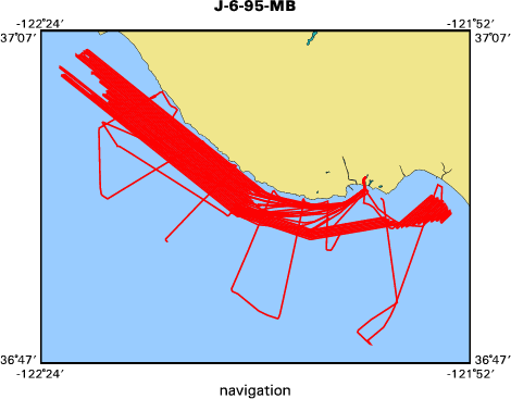
Location map
|

|
|
Bounding Coordinates
|
37.09805
-122.38052 -121.89430
36.80412
|
|
Dates
|
10/16/1995 (JD 289) to 11/30/1995 (JD 334)
|
|
Analog Materials
|
list
|
|
Index map
|
|
|
Crew
|
|
Roberto Anima
|
Chief Scientist, USGS Western Region
|
|
Andy Stevenson
|
Chief Scientist, USGS Western Region
|
|
Steve Eittreim
|
Chief Scientist, USGS Western Region
|
|
|
Equipment Used
|
|
Kleinsidescan
|
|
Geopulse
|
|
bathymetry
|
|
YoNav
|
|
GPS
|
|
|
Purpose
|
|
Continue collecting digital side-scan and
|
|
high-resolution geophysical data to; digital a side-scan data to produce a
|
|
mosaic of the northern Monterey Bay Santuary continental shelf area from as
|
|
near shore out to the continental slope, and to collect digital subbottom
|
|
profile data to better understand the shallow tectonics and paleomorphology of
|
|
the santuary.
|
|
|
Notes
|
|
|
Publications
|
|
Eittreim, Stephen L., and Noble, Marlene, editors, 2002, Seafloor geology and
|
|
natural environment of the Monterey Bay National Marine Sanctuary: Marine Geology, v
|
|
. 181
|
|
http://www.sciencedirect.com/
|
|
|
Journals > m > Marine Geology > Volumes 181 - 190 > Volume 181, Issues 1-3
|
|
|
|
Wong, F.L., and Eittreim, S.L., 2001, Continental Shelf GIS for the Monterey
|
|
Bay National Marine Sanctuary: U.S. Geological Survey Open-file Report 01-179,
|
|
1 CDROM,
|
|
http://geopubs.wr.usgs.gov/
|
open-file/of01-179/
|
|
|
Got Help?
|
For J-6-95-MB, we would appreciate any information on -- contract, days at sea, dive count, funding, information specialist, information to be derived, kms of navigation, NGDC Info, organization, owner, ports, project, project number, scanned materials, seismic description, station count, station description, submersible, summary, tabulated info.
|
|


