This page was last updated by the Content Provider on 08-Jan-2009
Compliance
This site is 508 Compliant
News Room Headline
Grays Harbor navigation study fact sheet now available on-line
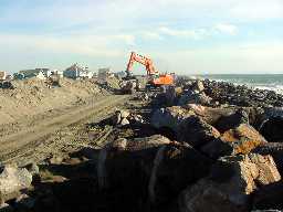
Grays Harbor North Jetty
Operations & Maintenance Study
Ocean Shores, Wash.
Description:
The Grays Harbor navigation project is an existing 24-mile-long deep-draft project located on Washington's southwest coast up the Chehalis River to the towns of Hoquiam, Aberdeen and Cosmopolis. There are several rock structural features of the navigation projects including the north and south jetties, which protect the harbor entrance. The purpose of the study is to analyze whether a less expensive solution exists to the problem of sands bypassing the north jetty and entering into the navigation channel in the harbor. In addition, the local entities are pursuing study authority to assess the feasibility beach erosion control as a benefit of any selected alternative.
Completed Features:
The study is not yet completed and no decision to construct has been made.
Status:
The study has been broken into two phases. Phase I is a research and development phase. One of the possible alternatives (in addition to lengthening the north jetty or modifying maintenance dredging and disposal practices, etc.) is to add a spur dike perpendicular to and on the north side of the north jetty. A spur dike would be designed to trap sands before they enter the harbor and also to change the local littoral drift at the jetty. Of the possible alternatives, only the spur dike needs basic research to investigate whether the concept is sound from an engineering standpoint. Discussions with local contractors affirm that, within limits, it is constructable. Physical and numerical modeling of the concept is now underway. See the model at Grays Harbor Model
Phase II of the study, if funded, would develop the list of alternatives and start the engineering and coordination process of evaluation of the alternatives. Any alternatives would be subject to public and other agency review as required by the National Environmental Policy Act and the Endangered Species Act. Phase II would also include an economic and life-cycle cost analysis.
Sponsor:
Port of Grays Harbor
Authority:
Operations and Maintenance authority of the Grays Harbor and Chehalis River Navigation Project.
 This site is 508 Compliant


 Grays Harbor North Jetty
Operations & Maintenance Study
Ocean Shores, Wash.
Description:
The Grays Harbor navigation project is an existing 24-mile-long deep-draft project located on Washington's southwest coast up the Chehalis River to the towns of Hoquiam, Aberdeen and Cosmopolis. There are several rock structural features of the navigation projects including the north and south jetties, which protect the harbor entrance. The purpose of the study is to analyze whether a less expensive solution exists to the problem of sands bypassing the north jetty and entering into the navigation channel in the harbor. In addition, the local entities are pursuing study authority to assess the feasibility beach erosion control as a benefit of any selected alternative.
Completed Features:
The study is not yet completed and no decision to construct has been made.
Status:
The study has been broken into two phases. Phase I is a research and development phase. One of the possible alternatives (in addition to lengthening the north jetty or modifying maintenance dredging and disposal practices, etc.) is to add a spur dike perpendicular to and on the north side of the north jetty. A spur dike would be designed to trap sands before they enter the harbor and also to change the local littoral drift at the jetty. Of the possible alternatives, only the spur dike needs basic research to investigate whether the concept is sound from an engineering standpoint. Discussions with local contractors affirm that, within limits, it is constructable. Physical and numerical modeling of the concept is now underway. See the model at
Grays Harbor North Jetty
Operations & Maintenance Study
Ocean Shores, Wash.
Description:
The Grays Harbor navigation project is an existing 24-mile-long deep-draft project located on Washington's southwest coast up the Chehalis River to the towns of Hoquiam, Aberdeen and Cosmopolis. There are several rock structural features of the navigation projects including the north and south jetties, which protect the harbor entrance. The purpose of the study is to analyze whether a less expensive solution exists to the problem of sands bypassing the north jetty and entering into the navigation channel in the harbor. In addition, the local entities are pursuing study authority to assess the feasibility beach erosion control as a benefit of any selected alternative.
Completed Features:
The study is not yet completed and no decision to construct has been made.
Status:
The study has been broken into two phases. Phase I is a research and development phase. One of the possible alternatives (in addition to lengthening the north jetty or modifying maintenance dredging and disposal practices, etc.) is to add a spur dike perpendicular to and on the north side of the north jetty. A spur dike would be designed to trap sands before they enter the harbor and also to change the local littoral drift at the jetty. Of the possible alternatives, only the spur dike needs basic research to investigate whether the concept is sound from an engineering standpoint. Discussions with local contractors affirm that, within limits, it is constructable. Physical and numerical modeling of the concept is now underway. See the model at