
Magnitude 6.7 - HAWAII REGION, HAWAII
2006 October 15 17:07:48 UTC
Earthquake Details
| Magnitude | 6.7 |
|---|---|
| Date-Time |
= Coordinated Universal Time = local time at epicenter |
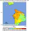
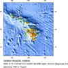
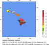
| Location | 19.820°N, 156.027°W |
| Depth | 29 km (18.0 miles) set by location program |
| Region | HAWAII REGION, HAWAII |
| Distances | |
| Location Uncertainty | horizontal +/- 3.9 km (2.4 miles); depth fixed by location program |
| Parameters | Nst=288, Nph=288, Dmin=24.5 km, Rmss=1.05 sec, Gp= 22°, M-type=teleseismic moment magnitude (Mw), Version=S |
| Source | U.S. Geological Survey, Hawaiian Volcano Observatory, Hawaii, USA |
| Event ID | ustwbh |
- This event has been reviewed by a seismologist.
Did you feel it?
Report shaking and damage at your location. You can also view a map displaying accumulated data from your report and others.
Earthquake Summary


The following is a release by the United States Geological Survey, National Earthquake Information Center: A strong earthquake occurred about 10 miles (15 km) north-northwest of Kailua Kona or 65 miles (100 km) west of Hilo, Hawai`i at 11:07 AM MDT, Oct 15, 2006 (7:07 AM HST in Hawaii). The magnitude and location may be revised when additional data and further analysis results are available.
Felt Reports
Numerous people suffered minor injuries, at least 1,173 buildings damaged, roads damaged and landslides blocked roads on Hawai`i. Power outages occurred throughout the Hawaiian Islands. Damage estimated at 73 million dollars. Felt (VII-VIII) in northern and western Hawai`i and (V-VI) in eastern and southern Hawai`i. Also felt (VI) on Maui; (V) on Lana`i, Moloka`i and O`ahu; (IV) on Kaua`i. A tsunami with a wave height of 10 cm was recorded at Kawaihae Harbor.
Tectonic Summary
The Island of Hawaii is the youngest island in a chain of volcanoes that stretches about 3500 miles across the northern Pacific Ocean. The island chain results from a magma source that originates deep beneath the crust. The ocean crust and lithosphere above the magma source, within the Pacific tectonic plate, move to the northwest with respect to the deep magma source. Over millions of years, new island volcanoes are formed and older volcanoes are carried away from the magma source, erode, and eventually subside beneath sea level.
The 15 October earthquake is probably not directly related to future volcanic eruptions. Non-volcanic Hawaiian earthquakes reflect the long-term accumulation and release of lithospheric stresses, rather than short-term processes associated with the motion of magma before or during an eruption. The long-term stresses consist in part of stresses generated in the crust and mantle by the weight of the volcanic rock that composes the islands. In that sense, most Hawaiian earthquakes that are not directly associated with eruptions are nonetheless broadly related to volcanic activity.
Earthquakes on the volcanic Island of Hawaii are not rare. The largest on record was the magnitude 7.9 1868 earthquake near the south coast which triggered a tsunami that drowned 46 people and which spawned numerous landslides that resulted in 31 deaths. A magnitude 6.9 tremor on August 21, 1951, damaged scores of homes on the Kona coast and triggered numerous damaging landslides.
Earthquake Information for Hawaii
 Tsunami Information
- West Coast & Alaska Tsunami Warning Center
- Pacific Tsunami Warning Center
- Recent Tsunamis
- Tsunami Information Links
The earthquake locations and magnitudes cited in these bulletins are very preliminary, and may disagree with the more accurate USGS locations and magnitudes computed using more extensive data sets.


 Historic Moment Tensor Solutions
- Preliminary Earthquake Report
- U.S. Geological Survey, National Earthquake Information Center
World Data Center for Seismology, Denver
