
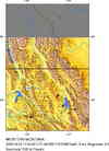
Magnitude 4.2 - WESTERN MONTANA
2006 March 22 17:24:32 UTC
Earthquake Details
| Magnitude | 4.2 (Light) |
|---|---|
| Date-Time |
= Coordinated Universal Time = local time at epicenter |
| Location | 48.828°N, 115.200°W |
| Depth | 8.2 km (5.1 miles) set by location program |
| Region | WESTERN MONTANA |
| Distances | |
| Location Uncertainty | Error estimate not available |
| Parameters | Nst= 84, Nph= 84, Dmin=97.8 km, Rmss=0 sec, Gp= 43°, M-type=local magnitude (ML), Version=R |
| Source | BUT |
| Event ID | uskpaz |
- This event has been reviewed by a seismologist.
Did you feel it?
Report shaking and damage at your location. You can also view a map displaying accumulated data from your report and others.
Earthquake Summary


Felt Reports
Items knocked from shelves (IV) and heard at Eureka. Felt (IV) at Troy; (III) at Kila, Libby and Rexford. Felt at Bigfork, Fortine, Great Falls, Kalispell, Olney and Poulson. Also felt at Bonners Ferry and Naples, Idaho.


- Preliminary Earthquake Report
- U.S. Geological Survey, National Earthquake Information Center
World Data Center for Seismology, Denver
