Magnitude 4.9 - GREATER LOS ANGELES AREA, CALIFORNIA - ci14155260
2005 June 16 20:53:26 UTC
A light earthquake occurred at 20:53:26 (UTC) on Thursday, June 16, 2005.
The magnitude 4.9 event has been located in the GREATER LOS ANGELES AREA, CALIFORNIA.
The hypocentral depth was estimated to be 12 km ( 7 miles). (This event has been reviewed by a seismologist.)
Earthquake Summary
Felt Reports
Two people injured at San Bernardino and one person at Lake Arrowhead. Felt (VI) at Angelus Oaks and (V) at Anza, Banning, Beaumont, Colton, Corona, Forest Falls, Highland, Loma Linda, Mentone, Moreno Valley, Perris, Redlands, Riverside, San Bernardino, San Jacinto, Sun City and Yucaipa. Felt (III- IV) in much of southern California. Also felt in Arizona and Nevada.
Earthquake Information for CALIFORNIA
Earthquake Details
| Magnitude |
4.9 |
| Date-Time |
Thursday, June 16, 2005 at 20:53:26 (UTC)
= Coordinated Universal Time
Thursday, June 16, 2005 at 1:53:26 PM
= local time at epicenter
|
| Location |
34.058°N, 117.011°W |
| Depth |
11.8 km (7.3 miles) |
| Region |
GREATER LOS ANGELES AREA, CALIFORNIA |
| Distances |
5 km (3 miles) NE (48°) from Yucaipa, CA
10 km (6 miles) E (94°) from Mentone, CA
15 km (10 miles) NNW (347°) from Beaumont, CA
25 km (15 miles) NE (54°) from Moreno Valley, CA
114 km (71 miles) E (89°) from Los Angeles Civic Center, CA
|
| Location Uncertainty |
horizontal +/- 0.2 km (0.1 miles); depth +/- 0.6 km (0.4 miles) |
| Parameters |
Nph=108, Dmin=10 km, Rmss=0.23 sec, Gp= 18°,
M-type=moment magnitude (Mw), Version=Q
|
| Source |
California Integrated Seismic Net
USGS/
Caltech/
CGS/
UCB/
UCSD/
UNR
|
| Event ID |
ci14155260 |
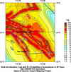
Earthquake Maps

Earthquake Location
Scientific & Technical Info
Additional Information, News Reports