
Magnitude 4.2 - ARKANSAS
2005 May 1 12:37:32 UTC
Earthquake Details
| Magnitude | 4.2 |
|---|---|
| Date-Time |
= Coordinated Universal Time = local time at epicenter |
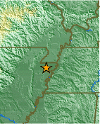
| Location | 35.830°N, 90.150°W |
| Depth | 9.7 km (6.0 miles) |
| Region | ARKANSAS |
| Distances | |
| Location Uncertainty | horizontal +/- 0.3 km (0.2 miles); depth +/- 1.3 km (0.8 miles) |
| Parameters | Nst= 26, Nph= 26, Dmin=5.6 km, Rmss=0.08 sec, Gp= 65°, M-type=moment magnitude (Mw), Version=B |
| Source | |
| Event ID | nmhwb0501a |
- This event has been reviewed by a seismologist.
Did you feel it?
Report shaking and damage at your location. You can also view a map displaying accumulated data from your report and others.
Earthquake Summary

Felt Reports
Felt (VI) at Keiser; (V) at Dell, Dyess, Joiner, Manila and Osceola; (IV) at Armorel, Batesville, Black Oak, Blytheville, Caraway, Cherry Valley, Colt, Crawfordsville, Earle, Etowah, Forest City, Harrisburg, Helena, Lake City, Leachville, Lepanto, Lexa, Luxora, Marked Tree, Monette, Newport, Rector, State University, Trumann, Tyronza, West Helena and Wilson. Also felt (IV) at Hornersville, Missouri and Burlison, Drummonds and Ripley, Tennessee. Felt in parts of Alabama, Arkansas, Illinois, Kentucky, Mississippi, Missouri and Tennessee.
Tectonic Summary
EARTHQUAKES IN THE NEW MADRID SEISMIC ZONE
 The New Madrid seismic zone
of southeast Missouri and adjacent States is the most
seismically active in North America east of the Rockies. During the winter of 1811-1812
three very large earthquakes devastated the area and were felt throughout most of the
Nation. They occurred a few weeks apart on
December 16, January 23, and February 7.
Hundreds of aftershocks, some severely damaging by themselves, continued for years.
Prehistoric earthquakes similar in size to those of 1811-1812 occurred in the middle
1400's and around 900 A.D. Strong, damaging earthquakes struck the southwestern end
of the seismic zone near Marked Tree, Arkansas in 1843 (magnitude 6.3), and the
northeastern end near Charleston, Missouri in 1895 (magnitude 6.6). Since 1900,
moderately damaging earthquakes have struck the seismic zone every few decades.
About twice a year people feel still smaller earthquakes that do not cause damage.
The New Madrid seismic zone
of southeast Missouri and adjacent States is the most
seismically active in North America east of the Rockies. During the winter of 1811-1812
three very large earthquakes devastated the area and were felt throughout most of the
Nation. They occurred a few weeks apart on
December 16, January 23, and February 7.
Hundreds of aftershocks, some severely damaging by themselves, continued for years.
Prehistoric earthquakes similar in size to those of 1811-1812 occurred in the middle
1400's and around 900 A.D. Strong, damaging earthquakes struck the southwestern end
of the seismic zone near Marked Tree, Arkansas in 1843 (magnitude 6.3), and the
northeastern end near Charleston, Missouri in 1895 (magnitude 6.6). Since 1900,
moderately damaging earthquakes have struck the seismic zone every few decades.
About twice a year people feel still smaller earthquakes that do not cause damage.
Earthquakes in the central and eastern U.S. are typically felt over a much broader region than in the western U.S. East of the Rockies, an earthquake can be felt over an area as much as ten times larger than a similar magnitude earthquake on the west coast. A magnitude 4.0 eastern U.S. earthquake typically can be felt at many places as far as 100 km (60 mi) from where it occurred, and it infrequently causes damage near its source. A magnitude 5.5 eastern U.S. earthquake usually can be felt as far as 500 km (300 mi) from where it occurred, and sometimes causes damage as far away as 40 km (25 mi).
FAULTS
Earthquakes everywhere occur on faults within bedrock, usually miles deep. The
earthquakes of the New Madrid seismic zone occur within a large network of faults called
the Reelfoot rift. The rift formed about 500 million years ago, when this region was
stretched in the northwest-southeast direction. Along a northeast-southwest zone at least
70 km (40 mi) wide and 500 km (300 mi) long, the rocks in the rift were slowly dropped
down about 1-2 km (1 mi) along some of the faults. Now the region is undergoing east-
west shortening, and the ancient faults of the Reelfoot rift are being reactivated to
generate earthquakes. Today the Reelfoot rift and the New Madrid seismic zone are
2,000 km (1,200 mi) from the nearest plate boundary, which is in the Caribbean Sea.
The network of faults in the seismic zone is buried beneath hundreds to thousands of feet of sand and mud. Four of the largest faults are recognized as alignments of abundant small earthquakes, and movements along two of these faults dammed rivers and created lakes during the earthquakes of 1811-1812. A few more deeply buried faults were detected during oil and gas exploration, and a few small faults are known from geologic mapping. However, many earthquakes occur away from the few known faults, so there must be additional, unknown faults that can generate earthquakes in the seismic zone. Accordingly, the best overall guide to seismic hazard in the New Madrid seismic zone is the earthquakes themselves.


- Preliminary Earthquake Report
- Cooperative New Madrid Seismic Network
