
 Feeds & Data
Magnitude 6.0 - NEVADA
2008 February 21 14:16:02 UTC
Earthquake Details
| Magnitude | 6.0 |
|---|---|
| Date-Time |
|
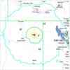
| Location | 41.153°N, 114.867°W |
| Depth | 6.7 km (4.2 miles) set by location program |
| Region | NEVADA |
| Distances |
|
| Location Uncertainty | Error estimate not available |
| Parameters | NST=282, Nph=282, Dmin=55.1 km, Rmss=0 sec, Gp= 14°, M-type=moment magnitude (Mw), Version=B |
| Source |
|
| Event ID | us2008nsa9 |
- This event has been reviewed by a seismologist.
- Did you feel it? Report shaking and damage at your location. You can also view a map displaying accumulated data from your report and others.
Earthquake Summary


The following is a release by the United States Geological Survey, National Earthquake Information Center: An earthquake occurred 15 km (10 miles) ESE of Wells, Nevada 15 km (10 miles) ESE of Wells, Nevada at 7:16 AM MST, Feb 21, 2008 (6:16 AM PST in Nevada). The magnitude and location may be revised when additional data and further analysis results are available.
Felt Reports
At least three people injured and over twenty buildings heavily damaged and almost seven hundred buildings slightly damaged (VI) at Wells, Nevada. Felt (V) at Jackpot; (IV) at Battle Mountain, Carlin, Elko, Mountain City and Spring Creek; (III) at Ely, Eureka, Golconda, Lovelock and Winnemucca; (II) at Fallon and Reno, Nevada; (V) at Grand View and Rogerson; (IV) at Castleford, Filer, Hansen, Heyburn, Malad City, Malta, Paul, Rupert, Twin Falls and Wendell, (III) at American Falls, Bellevue, Boise, Buhl, Burley, Caldwell, Declo, Dietrich, Emmett, Fairfield, Garden Valley, Glenns Ferry, Gooding, Hagerman, Hailey, Hazelton, Idaho City, Inkom, Jerome, Ketchum, Kimberly, Middleton, Murtaugh, Nampa, Pocatello and Shoshone, (II) at Eagle, Garden City, Idaho Falls, Kellogg, Kuna, Lava Hot Springs, Mccammon, Meridian, Mountain Home, Preston and Star, Idaho; (V) at Wendover, (IV) at Farmington, Garland Salt Lake City and Snowville, (III) at American Fork, Brigham City, Clearfield, Corinne, Draper, Dugway, Grantsville, Hill AFB, Honeyville, Hooper, Hyde Park, Hyrum, Layton, Lehi, Logan, Ogden, Plymouth, Provo, Richmond, Roy, Sandy, Stockton, Syracuse, Tooele, Tremonton and West Jordan, (II) at Alpine, Bountiful, Delta, Kaysville, Lewiston, Magna, Midvale, North Salt Lake, Orem, Park City, Pleasant Grove, Providence, Riverton, Smithfield, South Jordan, Wellsville and Woods Cross, Utah; (II) at Spokane, Washington. Also felt at Laveen, Phoenix and Tucson, Arizona; Carmel Valley, Citrus Heights, Fort Bragg, Fresno, Huntington Beach, Midway City, Modesto, Newcastle, Oakland, Orange, Pasadena, Redwood City, Rocklin, Sacramento, San Ramon, Stockton and Ontario, California; Brighton and Fruita, Colorado; Aberdeen, Arco, Arimo, Bliss, Eden, Fish Haven, Greenleaf, Hammett, Homedale, Howe, Idaho Falls, Letha, Lucile, Mccall, Montpelier, Mountain Home A F B, Mullan, Murphy, New Plymouth, Paris, Parma, Pinehurst, Rockland, Soda Springs, Weiser, Weston and Wilder, Idaho; Absarokee, Montana; Albuquerque, New Mexico; Baker, Crescent Valley, Deeth, Denio, Fernley, Henderson, Nellis AFB, Overton, Pioche, Round Mountain, Tonopah and Yerington, Nevada; Burns, Harper, Jordan Valley, Nyssa and Ontario, Oregon; Bingham Canyon, Cedar Valley, Centerville, Clarkston, Cornish, Dutch John, Eden, Fielding, Grouse Creek, Hinckley, Huntsville, Lindon, Mendon, Mona, Morgan, Orem, Park, City, Payson, Portage, Rush Valley, Salem, Spanish Fork, Springville, Talmage, Vernon, Willard, Utah; Afton and Rock Springs, Wyoming.
Tectonic Summary
Seismological data from this earthquake show that it occurred on a normal fault that trends roughly north-south and has a dip of 30-60 degrees. The revised location of the mainshock puts the earthquake in the area northeast of Wells, Nevada, where geologically young faulting is poorly expressed. The USGS Quaternary Faults and Folds Database describes a network of widely distributed faults west of Wells Peak. Based on the revised location, the distribution of several aftershocks, and the depth of the mainshock, it is difficult to associate the earthquake with a specific fault.
A significant fault in the region that shows evidence of geologically young movement is the 64-km-long Independence Valley fault zone, which bounds the western side of the Pequop Mountains, but it is located more than 20 km southeast of the revised epicentral location and was probably not the source of the earthquake.
Earthquakes in Nevada are not uncommon. One of the most significant sequences of earthquakes in the western U.S. occurred in Nevada during the first half of the 20th century. The sequence started in 1915, when a magnitude 7.1 earthquake occurred in Pleasant Valley south of Winnemucca. The sequence culminated with a series of four major earthquakes that ranged in magnitude between 6.6 to 7.1 in 1954 the vicinity of the Carson Sink and Dixie Valley. This sequence of earthquakes defines the Central Nevada Seismic Belt.
The geologic expression of normal faults north of Wells indicate relatively low long-term rates of activity, but this event demonstrates that these faults remains active and have the potential to generate sizeable earthquakes. It is noteworthy that the geologic expression of normal faults northeast of Wells is similar to hundreds of other faults throughout the Basin and Range Province of the western United States.
Earthquake Maps


Scientific & Technical Information

- Preliminary Earthquake Report
- U.S. Geological Survey, National Earthquake Information Center:
World Data Center for Seismology, Denver
