
 Feeds & Data
Magnitude 7.2 - ANDREANOF ISLANDS, ALEUTIAN IS., ALASKA
2007 December 19 09:30:30 UTC
Earthquake Details
| Magnitude | 7.2 |
|---|---|
| Date-Time |
|
| Location | 51.495°N, 179.473°W |
| Depth | 56.3 km (35.0 miles) |
| Region | ANDREANOF ISLANDS, ALEUTIAN IS., ALASKA |
| Distances |
|
| Location Uncertainty | horizontal +/- 8.8 km (5.5 miles); depth +/- 10.9 km (6.8 miles) |
| Parameters | NST=130, Nph=130, Dmin=197.9 km, Rmss=0.62 sec, Gp= 54°, M-type=moment magnitude (Mw), Version=6 |
| Source |
|
| Event ID | us2007lcaq |
- This event has been reviewed by a seismologist.
- Did you feel it? Report shaking and damage at your location. You can also view a map displaying accumulated data from your report and others.
Earthquake Summary

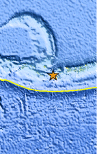
The following is a release by the United States Geological Survey, National Earthquake Information Center: An earthquake occurred 35 km (25 miles) NW of Amatignak Island, Alaska, 80 km (50 miles) SE of Semisopochnoi Island, Alaska, 2100 km (1300 miles) WSW of Anchorage, Alaska, 2925 km (1820 miles) W of JUNEAU, Alaska at 2:30 AM MST, Dec 19, 2007 (Dec 18 at 11:30 PM AHST in Aleutian Islands). The magnitude and location may be revised when additional data and further analysis results are available. No reports of damage or casualties have been received at this time.
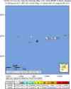
Felt Reports
Felt at Chugiak and Soldotna.
Tectonic Summary
The Aleutian Islands earthquake of December 19, 2007, occurred on the boundary between the North America plate and the Pacific plate. In this region, the Pacific plate moves to the northwest with respect to the North American plate with a velocity of about 72 mm/y. The Pacific plate subducts beneath the North American plate at the Aleutian trench. The earthquake occurred as thrust-faulting on the interface between the plates.
The earthquake of December 19, 2007, ruptured a segment of the Pacific/North America plate boundary that is spatially situated between the segments of the plate boundary that ruptured in the great Aleutian Island earthquakes of March 9, 1957 (magnitude 8.6) and February 4, 1965 (magnitude 8.7). Great earthquakes also occurred in the central Aleutian arc on May 7, 1986 (magnitude 8, about 300 km distant from the site of the 2007 earthquake) and June 10, 1996 (magnitude 7.9, about 150 km distant from the site of the 2007 earthquake)
Earthquake Information for Alaska
 Tsunami Information
- NOAA West Coast & Alaska Tsunami Warning Center
- NOAA Pacific Tsunami Warning Center
- Tsunami Information Links
The earthquake locations and magnitudes cited in these NOAA tsunami bulletins are very preliminary and may be superceded by USGS locations and magnitudes computed using more extensive data sets.
Earthquake Maps


Scientific & Technical Information

Additional Information, News Reports
- Preliminary Earthquake Report
- U.S. Geological Survey, National Earthquake Information Center:
World Data Center for Seismology, Denver
