
 Feeds & Data
Magnitude 6.4 - ANDREANOF ISLANDS, ALEUTIAN IS., ALASKA
2007 August 15 20:22:13 UTC
Earthquake Details
| Magnitude | 6.4 |
|---|---|
| Date-Time |
|
| Location | 50.568°N, 177.507°W |
| Depth | 21.2 km (13.2 miles) (poorly constrained) |
| Region | ANDREANOF ISLANDS, ALEUTIAN IS., ALASKA |
| Distances |
|
| Location Uncertainty | horizontal +/- 10.6 km (6.6 miles); depth +/- 24.5 km (15.2 miles) |
| Parameters | NST=164, Nph=164, Dmin=241.3 km, Rmss=0.74 sec, Gp=119°, M-type=body magnitude (Mb), Version=6 |
| Source |
|
| Event ID | us2007gbb3 |
- This event has been reviewed by a seismologist.
- Did you feel it? Report shaking and damage at your location. You can also view a map displaying accumulated data from your report and others.
Earthquake Summary
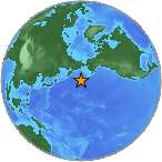
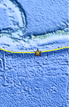
The following is a release by the United States Geological Survey, National Earthquake Information Center: An earthquake occurred about 135 km (85 miles) SE of Amatignak Island, Alaska or 2070 km (1290 miles) WSW of Anchorage, Alaska at 2:22 PM MDT, Aug 15, 2007 (11:22 AM AHDT in Alaska). The magnitude and location may be revised when additional data and further analysis results are available. This earthquake is located in a remote area and no damage or casualties are expected.
Felt Reports
WP 6.5 (GS).
Earthquake Maps
Earthquake Location
Location Maps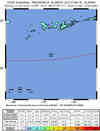
ShakeMap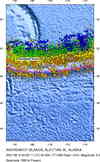
Historical Seismicity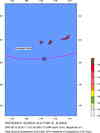
Seismic Hazard Map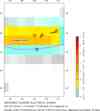
EQ Density Map
Google Map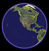
Google Earth KML
(Requires Google Earth)- Did you feel it? Report shaking and damage at your location. You can also view a map displaying accumulated data from your report and others.
Scientific & Technical Information

Additional Information, News Reports
- Preliminary Earthquake Report
- U.S. Geological Survey, National Earthquake Information Center:
World Data Center for Seismology, Denver
