Feeds & Data
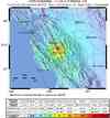
Magnitude 5.6 - SAN FRANCISCO BAY AREA, CALIFORNIA
2007 October 31 03:04:54 UTC
Earthquake Details
| Magnitude | 5.6 |
|---|---|
| Date-Time |
|
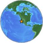
| Location | 37.432°N, 121.776°W |
| Depth | 9.2 km (5.7 miles) |
| Region | SAN FRANCISCO BAY AREA, CALIFORNIA |
| Distances |
|
| Location Uncertainty | horizontal +/- 0.1 km (0.1 miles); depth +/- 0.3 km (0.2 miles) |
| Parameters | NST=250, Nph=250, Dmin=3 km, Rmss=0.07 sec, Gp= 32°, M-type=regional moment magnitude (Mw), Version=4 |
| Source | |
| Event ID | nc40204628 |
- This event has been reviewed by a seismologist.
- Did you feel it? Report shaking and damage at your location. You can also view a map displaying accumulated data from your report and others.
Earthquake Summary

Tectonic Summary
The earthquake occurred about 8 km (5 miles) NNE (31°) from Alum Rock, CA at Tuesday, October 30, 2007 at 08:04:54 PM PDT. The quake was located at a depth of 8-9 km (about 5 miles) on the Calaveras Fault. The event caused strong shaking in the epicentral region with over 60,000 felt reports, extending to beyond Santa Rosa to the NW, the Sierras to the east, and King City to the south. Based on the distribution of aftershocks with respect to the hypocenter, focal mechanisms, and moment tensor solutions, the earthquake ruptured a patch at depth on the near-vertical Calaveras fault for a length of about 5km (3 miles), starting at the hypocenter and progressing toward the SE. Directivity analysis of recorded seismograms supports this rupture direction. Geologists did not find any surface rupture along the fault, which would have been unusual for an earthquake of this size and depth in any case.
The Calaveras Fault, like the San Andreas Fault to the west, is a right-lateral strike-slip fault that is part of the San Andreas Fault System in the San Francisco Bay region. This system forms the plate tectonic boundary between the North American Plate and the Pacific Plate. Geodetic monitoring of the Calaveras fault near this location indicates about 6 mm/yr (0.24 inches/year), but further south near Hollister the long-term offset rate of about 17 mm/year (0.66 inches/year). Historic earthquakes on the Calaveras fault suggest that this fault ruptures in moderate sized earthquakes (M5-6.5) that occur on time scales of decades (rather than larger earthquakes that occur on time scales of hundreds of years). The fault is also known to be creeping aseismically along much of its length, which may contribute to the release of stress.
Based on analysis of prior Calaveras fault seismicity patterns, USGS scientists predicted in a paper published in 1990 that this section of the Calaveras fault was likely to fail in a M5.5 quake. The Alum Rock quake appears to fulfill that prediction. Moreover, preliminary analysis indicates that the quake ruptured a section of the Calaveras fault that last ruptured 52 years earlier during the 9/5/1955 M5.5 earthquake. It is also possible that either the 6/11/1903 M5.4 or 8/3/1903 M5.3 quake also ruptured the same segment ~52 years prior. While intriguing, the latter hypothesis cannot be confirmed because there are no seismograms for the 1903 quakes.
USGS seismologists have calculated stress increases from the Alum Rock quake on nearby parts of the Hayward and Northern Calaveras faults, but since we don't know how close the more stressed parts of these faults are to failure already, we do not know whether those stress perturbations significantly affect the likelihood of earthquakes on these faults in the near term. A few weeks after the Alum Rock earthquake the estimated probabilities for M>6.7 earthquakes on the Northern Calaveras and Hayward faults will return to long-term rates of 11 and 27%, respectively.