
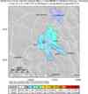
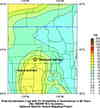
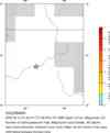
Magnitude 3.8 - COLORADO
2006 February 10 21:48:13 UTC

Earthquake Details
| Magnitude | 3.8 (Minor) |
|---|---|
| Date-Time |
= Coordinated Universal Time = local time at epicenter |
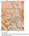
| Location | 39.580°N, 107.443°W |
| Depth | 5 km (3.1 miles) set by location program |
| Region | COLORADO |
| Distances | |
| Location Uncertainty | horizontal +/- 5.6 km (3.5 miles); depth fixed by location program |
| Parameters | Nst= 35, Nph= 35, Dmin=60 km, Rmss=1.17 sec, Gp= 58°, M-type=local magnitude (ML), Version=Q |
| Source | USGS NEIC (WDCS-D) |
| Event ID | usiza3 |
- This event has been reviewed by a seismologist.
Did you feel it?
Report shaking and damage at your location. You can also view a map displaying accumulated data from your report and others.

- Preliminary Earthquake Report
- U.S. Geological Survey, National Earthquake Information Center
World Data Center for Seismology, Denver
