
Magnitude 4.9 - OFFSHORE OREGON
2004 July 12 16:45:00 UTC


Earthquake Details
| Magnitude | 4.9 (Light) |
|---|---|
| Date-Time |
= Coordinated Universal Time = local time at epicenter |
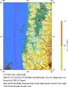
| Location | 44.329°N, 124.490°W |
| Depth | 28.9 km (18.0 miles) set by location program |
| Region | OFFSHORE OREGON |
| Distances | |
| Location Uncertainty | horizontal +/- 1.5 km (0.9 miles); depth fixed by location program |
| Parameters | Nst= 21, Nph= 22, Dmin=55 km, Rmss=0.24 sec, Gp=245°, M-type=duration magnitude (Md), Version=1 |
| Source | |
| Event ID | uw07121645 |
- This event has been reviewed by a seismologist.
Did you feel it?
Report shaking and damage at your location. You can also view a map displaying accumulated data from your report and others.


- Preliminary Earthquake Report
- Pacific Northwest Seismograph Network
