
Magnitude 3.7 - EASTERN KENTUCKY
2004 September 17 15:21:43 UTC
Earthquake Details
| Magnitude | 3.7 |
|---|---|
| Date-Time |
= Coordinated Universal Time = local time at epicenter |
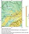
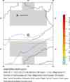
| Location | 36.932°N, 84.006°W |
| Depth | 1.2 km (~0.7 mile) set by location program |
| Region | EASTERN KENTUCKY |
| Distances | |
| Location Uncertainty | Error estimate not available |
| Parameters | Nst= 43, Nph= 43, Dmin=171.2 km, Rmss=0 sec, Gp= 58°, M-type="Nuttli" surface wave magnitude (MLg), Version=Q |
| Source | USGS NEIC (WDCS-D) |
| Event ID | usnmar |
- This event has been reviewed by a seismologist.
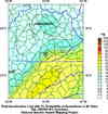
Did you feel it?
Report shaking and damage at your location. You can also view a map displaying accumulated data from your report and others.
Earthquake Maps

Earthquake Location


Did you feel it?
Report shaking and damage at your location. You can also view a map displaying accumulated data from your report and others.
- Preliminary Earthquake Report
- U.S. Geological Survey, National Earthquake Information Center
World Data Center for Seismology, Denver
