
 Feeds & Data
Magnitude 6.6 - SOUTH SANDWICH ISLANDS REGION
2008 February 10 12:22:02 UTC
Earthquake Details
| Magnitude | 6.6 |
|---|---|
| Date-Time |
|
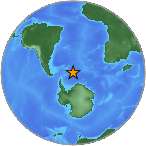
| Location | 60.684°S, 25.544°W |
| Depth | 8 km (5.0 miles) set by location program |
| Region | SOUTH SANDWICH ISLANDS REGION |
| Distances | 205 km (130 miles) SSE of Bristol Island, South Sandwich Islands 465 km (290 miles) SSE of Visokoi Island, South Sandwich Islands 975 km (610 miles) SE of Grytviken, South Georgia 3270 km (2030 miles) N of South Pole, Antarctica |
| Location Uncertainty | horizontal +/- 7.8 km (4.8 miles); depth fixed by location program |
| Parameters | NST=174, Nph=174, Dmin=>999 km, Rmss=1.04 sec, Gp= 25°, M-type=moment magnitude (Mw), Version=R |
| Source |
|
| Event ID | us2008ngak |
- This event has been reviewed by a seismologist.
- Did you feel it? Report shaking and damage at your location. You can also view a map displaying accumulated data from your report and others.
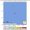
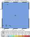
Earthquake Maps


Scientific & Technical Information
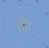
 Historic Moment Tensor Solutions
- Preliminary Earthquake Report
- U.S. Geological Survey, National Earthquake Information Center:
World Data Center for Seismology, Denver
