It is hereby declared to be the policy of the United States that certain selected rivers of the Nation which, with their immediate environments, possess outstandingly remarkable scenic, recreational, geologic, fish and wildlife, historic, cultural or other similar values, shall be preserved in free-flowing condition, and that they and their immediate environments shall be protected for the benefit and enjoyment of present and future generations. The Congress declares that the established national policy of dams and other construction at appropriate sections of the rivers of the United States needs to be complemented by a policy that would preserve other selected rivers or sections thereof in their free-flowing condition to protect the water quality of such rivers and to fulfill other vital national conservation purposes. (Wild & Scenic Rivers Act, October 2, 1968)
The Wild and Scenic Rivers Act celebrates its 40th Anniversary in 2008. The Act, championed by Senator Frank Church, and signed into law by President Lyndon Johnson on October 2, 1968, protects the free-flowing waters of many of our nation's most spectacular rivers. The Act is notable for safeguarding the special character of these rivers, while also recognizing the potential for appropriate use and development. These living landscapes are uniquely managed to protect the public's enjoyment of these heritage resources for present and future generations. The managing agencies also try to accommodate and reflect community and landowner interests. Every designation preserves a sliver of traditional American experiences that are important to local communities, such as fishing and boating, or wading in waters our nation's forefathers would have recognized and enjoyed.
The Bureau of Land Management manages 38 Wild and Scenic rivers including more than 2,050 river miles and 1,002,000 acres. The Bureau’s National Landscape Conservation System provides national level management and policy guidance for these rivers and represents the Bureau on the Interagency Wild and Scenic Rivers Coordinating Council.
The Act provides three levels of protection: wild, scenic, and recreational. “Wild” rivers are free of dams, generally inaccessible except by trail, and represent vestiges of primitive America. “Scenic” rivers are free of dams, with shorelines or watersheds still largely primitive and shorelines largely undeveloped, but accessible in places by roads. “Recreational” rivers are readily accessible by road or railroad, may have some development along their shorelines, and may have been dammed in the past.
California Wild and Scenic Rivers
American (North Fork)
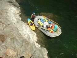
Fasten your life jackets--It's going to be a bumpy ride. The famous Giant Gap run of the even more famous North Fork American River is one of the most challenging runs in Northern California. Cliffs tower 2,000 feet above clear green streams smashing a path through rapids choked with boulders. Heaps of mine tailings and an old cabin ruin border the course of this roller coaster ride through the historic Mother Lode.
Eel (Middle Fork)
Klamath
Just south of the Oregon Border, BLM's Stateline boat ramp and primitive campground is used as a take-out point on the Klamath River for the 17 mile stretch of class I-V whitewater upriver. For more information including permitted guides on this whitewater run see the BLM Klamath Falls Field Office website.
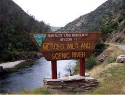
Merced
From the high country of Yosemite National Park, the Merced River shows no mercy on its headlong rush through glacially-carved canyons, rugged mountains and foothills to the San Joaquin Valley. Ample access points allow you to punch rapids at your own pace. After a full day on the river, check out the Willow Placer, Railroad Flat or McCabe Flat campgrounds.
Trinity
Near the fishing resort town of Lewiston, the Nationally recognized Wild and Scenic Trinity River emerges clear and cold from Clair Engle Lake and Lewiston Lake into a mountain valley. Soon the valley narrows and the Trinity looks like other famous fly fishing streams from a catalog. Below Douglas City the river changes to a broad canyon surrounded by mountains. Boating difficulty remains consistent with class I and II rapids, gravel bars, brush hazards and fallen trees. Trinity County has an abundance of camping places Steel Bridge, Douglas City and Junction City campgrounds are on the river. Downstream of Steiner Flat, you can choose your own unimproved site. The Trinity River (from Lewiston Lake to Pigeon Point) has many access points and other facilities. Please see the map for specific locations and directions. other information about BLM lands within the region at BLM's Redding Field Office.
Tuolumne
California's premier whitewater river is a slalom course of boulders of escalating intensity. Staircase rapids, chutes, and pools by the score and Yosemite National Park create the ultimate river adventure, a journey by turns exciting and pristine. World famous, the Tuolumne River is where the ambitious earn their stripes.


