
USGS/Cascades Volcano Observatory, Vancouver, Washington
DESCRIPTION:
Debris Flows, Mudflows, Jökulhlaups, and Lahars
- Debris Flows, Mudflows, and Lahars
- Glacial Outburst Floods - Jökulhlaups
- Mount Hood, Oregon
- Mount Rainier - Glacial Outburst Floods
- Mount Rainier Historical Mudflows
- Mount St. Helens May 18, 1980
- Nevado del Ruiz Volcano, Colombia, 1984
|
Debris Flows, Mudflows, Lahars
|
-

-
MSH80_mudline_muddy_river_with_USGS_scientist_10-23-80.jpg
Nearly 135 miles (220 kilometers) of river channels surrounding the volcano were affected by the lahars of May 18, 1980. A mudline left behind on trees shows depths reached by the mud. A scientist (middle right) gives scale. This view is along the Muddy River, southeast of Mount St. Helens.
USGS Photograph taken on October 23, 1980, by Lyn Topinka.
[medium size] ...
[large size]
From:
Brantley and Power, 1985,
Reports from the U.S. Geological Survey's Cascades Volcano Observatory at
Vancouver, Washington:
Earthquake Information Bulletin, v.17, n.1, January-February 1985, p.20.
-
Lahar is an Indonesian word describing mudflows
and debris flows that originate from the slopes of a volcano.
Both types of flows contain a high concentration of rock debris to give
them the internal strength necessary to transport hugh boulders as well as
buildings and bridges and to exert extremely high impact forces against objects
in their paths. Debris flows are coarser and less cohesive than
mudflows. As lahars become dilute in downstream direction they become
hyperconcentrated streamflows. Lacking internal strength, the mixture of
rock debris and water takes on different flow properties. The coarser debris in
this type of flow is no longer held in suspension by matrix strength and
therefore settles to the bottom of the flow.
-
Lahars can be of any size. They may be as small as several centimeters
wide and deep, flowing less than one meter per second. Steep, unvegetated
slopes during a heavy rain are often good sites to observe such small flows. At
the other extreme, they can be a few hundred meters wide, tens of meters deep,
flow at several tens of meters per second, and travel over 100 kilometers from a
volcano. Such catastrophic lahars are triggered by volcanic eruptions or by
massive landslides such as the one that occurred on
May 18, 1980, at Mount St. Helens volcano.
-
Lahars are commonly initiated by:
- large landslides of water-saturated debris,
- heavy rainfall eroding volcanic deposits,
- sudden melting of snow and ice near a volcanic vent by radiant heat or
on the flanks of a volcano by
pyroclastic flows, or
- breakout of water from glaciers, crater lakes, or from
lakes dammed by volcanic eruptions.
Since 1980, lahars have formed by all of these processes at Mount St. Helens.
From:
Tilling, Topinka, and Swanson, 1990,
Eruptions of Mount St. Helens: Past, Present, and Future
-
Volcanic debris flows:
mobile mixtures of volcanic debris and water popularly called mudflows
often accompany
pyroclastic eruptions,
if water is available to erode and
transport the loose pyroclastic deposits on the steep slopes of
stratovolcanoes.
Destructive mudflows and debris flows began within minutes of the onset of the
May 18 eruption, as the hot pyroclastic materials in the
debris avalanche,
lateral blast, and
ash falls
melted snow and glacial ice on the upper slopes of Mount St. Helens.
Such flows are also called lahars, a term borrowed from Indonesia,
where volcanic eruptions have produced many such deposits.
From:
Miller, 1989,
Potential Hazards from Future Volcanic Eruptions in California:
USGS Bulletin 1847
-
A debris flow (sometimes called mudflow) is a flowing mixture of
water-saturated debris that moves downslope under the force of gravity. Debris
flows consists of material varying in size from clay to blocks several tens of
meters in maximum dimension. When moving, they resemble masses of wet concrete
and tend to flow downslope along channels or stream valleys. Debris flows are
formed when loose masses of unconsolidated wet debris become unstable. Water
may be supplied by rainfall, by melting of snow or ice, or by overflow of a
crater lake. Debris flows may be formed directly if lava or pyroclastic flows
are erupted onto snow and ice. Debris flows may be either hot or cold,
depending on their manner of origin and temperature of their constituent debris.
-
Debris flows can travel great distances down valleys, and debris-flow fronts can
move at high speeds -- as much as 85 kilometers per hour. Debris flows produced
during an eruption of
Cotopaxi volcano in Ecuador
in 1877 traveled more than 320
kilometers down one valley at an average speed of 27 kilometers per hour
(Macdonald, 1972). High-speed debris flows may climb valley walls on the
outsides of bends, and their momentum may also carry them over obstacles.
Debris flows confined in narrow valleys or by constructions in valleys can
temporarily thicken and fill valleys to heights of 100 meters or more (Crandell,
1971).
-
The major hazard to human life from debris flows is from burial or impact by
boulders and other debris. People and animals also can be severely burned by
debris flows carrying hot debris. Buildings and other property in the path of a
debris flow can be buried, smashed, or carried away. Because of their
relatively high density and viscosity, debris flows can move and even carry away
vehicles and other objects as large as bridges and locomotives.
-
Because debris flows are confined to areas downslope and downvalley from their
points of origin, people can avoid them by seeking high ground. Debris-flow
hazard decreases gradually downvalley from possible source volcanoes but more
abruptly with increasing altitude above valley floors. People seeking to escape
flows should climb valley sides rather than try to outrun debris flows in valley
bottoms. During eruptive activity or precursors to eruptions, local government
officials may ask form prompt evacuation of areas likely to be affected.
From:
Myers and Brantley, 1995,
Volcano Hazards Fact Sheet: Hazardous Phenomena at Volcanoes,
USGS Open-File Report 95-231
-
Lahars (Debris Flows or Mudflows) are mixtures of water,
rock, sand, and mud that rush down valleys leading away from a
volcano. They can travel over 50 miles downstream, commonly
reaching speeds between 20 and 40 miles per hour. Sometimes they
contain so much rock debris (60-90% by weight) that they look like
fast-moving rivers of wet concrete. Close to the volcano they have
the strength to rip huge boulders, trees, and houses from the
ground and carry them downvalley. Further downstream they simply
entomb everything in mud. Historically, lahars have been one of
the most deadly volcanic hazards.
-
Lahars can form in a variety of ways, either during an
eruption or when a volcano is quiet. Some examples include the
following: (1) rapid release of water from the breakout of a summit
crater lake; (2) generation of water by melting snow and ice,
especially when a pyroclastic flow erodes a glacier; (3) flooding
following intense rainfall; and (4) transformation of a volcanic
landslide into a lahar as it travels downstream.
From:
Hoblitt, et.al., 1987,
Volcanic Hazards with Regard to Siting Nuclear-Power Plants
in the Pacific Northwest, USGS Open-File Report 87-297
-
Lahars (also called volcanic debris flows or mudflows)
are mixtures of water-saturated rock debris that flow
downslope under the force of gravity. ... Rock debris in lahars ranges in
size from clay to blocks several tens of meters in maximum dimension.
When moving,
lahars resemble masses of wet concrete and tend to be channeled into
stream valleys. Lahars are formed when loose
masses of unconsolidated, wet debris become mobilized. ...
|
Glacial Outburst Floods - Jökulhlaups
|
-
 [Image,76K,JPG]
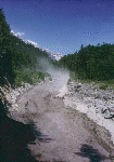
Debris flow at Tahoma Creek, July 26, 1988
-- USGS Photo by G. G. Parker, USGS/WRD/Tacoma
From:
Walder and Driedger, 1993,
Volcano Fact Sheet: Glacier-generated debris flows at Mount Rainier:
USGS Open-File Report 93-124
-
... The smallest, but most frequent, debris flows at Mount Rainier
begin as
glacial outburst floods,
also called by the Icelandic term "jokulhlaup"
(pronounced "yo-kul-h-loip"). Outburst floods at
Mount Rainier form from sudden release of water
stored at the base of glaciers or within the glacier ice. ...
-
Outburst floods become debris flows
by incorporating large quantities of sediment from
valley floors and walls, often by
triggering landslides that mix with the flood waters.
The transformation from water flood to debris flow occurs in areas
where streams have eroded glacially derived sediments and
sediment-rich, stagnant glacier ice that was stranded in
valleys as glaciers thinned and retreated earlier in this century. ...
-
 [Image,54K,JPG]
Mount Hood and White River Drainage, with 1998 Flow Deposits
-- USGS Photo by Cynthia Gardner, September 4, 1998
From:
Swanson, et.al., 1989,
IGC Field Trip T106: Cenozoic Volcanism in the Cascade Range and
Columbia Plateau, Southern Washington and Northernmost Oregon:
American Geophysical Union Field Trip Guidebook T106
-
Jökulhlaups (glacial-outburst floods)
have been recorded from the
Zigzag,
Ladd,
Coe, and
White River Glaciers.
In 1922, a dark debris flow issued from a
crevasse high on Zigzag Glacier and moved 650 meters
over the ice before entering
another crevasse; this event initiated a scare that Mount Hood was erupting
(Conway, 1921).
The Ladd Glacier jökulhlaup in 1961 destroyed sections of the
road around the west side of the mountain and partly undermined a tower of a
major powerline (Birch, 1961).
The Coe Glacier outburst occurred around 1963,
causing a section of trail to be abandoned
and the "round-the-mountain" trail to
be rerouted farther from the glacier.
Jökulhlaups from White River Glacier
were
reported in 1926, 1931, 1946, 1949, 1959, and 1968;
the Highway 35 bridge over
the White River was destroyed during each episode. The more frequent outbursts
from White River Glacier
may be due in part to an increase in size of the fumarole field at the head of the glacier at
Crater Rock (Cameron, 1988).
-
 Mount Hood Mudflows and Lahars Menu
|
Mount Rainier - Glacial Outburst Floods
|
-
[Image,76K,JPG]
Debris flow at Tahoma Creek, July 26, 1988
-- USGS Photo by G. G. Parker, USGS/WRD/Tacoma
From:
Walder and Driedger, 1993,
Volcano Fact Sheet: Glacier-generated debris flows at Mount Rainier:
USGS Open-File Report 93-124
-
... The smallest, but most frequent, debris flows at Mount Rainier
begin as
glacial outburst floods,
also called by the Icelandic term "jokulhlaup"
(pronounced "yo-kul-h-loip"). Outburst floods at
Mount Rainier form from sudden release of water
stored at the base of glaciers or within the glacier ice. ...
-
Outburst floods become debris flows
by incorporating large quantities of sediment from
valley floors and walls, often by
triggering landslides that mix with the flood waters.
The transformation from water flood to debris flow occurs in areas
where streams have eroded glacially derived sediments and
sediment-rich, stagnant glacier ice that was stranded in
valleys as glaciers thinned and retreated earlier in this century. ...
-
Glacier-generated debris flows at Mount Rainier
travel downstream at speeds of 5-10 meters per second (10-20 miles per
hour) or more. ...
These flows typically have steep, bouldery
snouts--up to 10-20 meters (30-60 feet) high in the most
constricted parts of a stream valley--followed by a churning
mass of mud, rock, and vegetation. Their deafening noise is
often accompanied by strong local wind, thick dust clouds, and
violent ground shaking.
-
Debris flows usually follow stream channels and construct
their own levees as they move, but their exact paths are
unpredictable.
As a debris flow moves downstream from
Mount Rainier's steep flanks onto relatively gentle slopes, the
flow's bouldery snout may clog the stream channel; the
moving mass behind the snout may then overtop the banks and
cut a new channel, perhaps through forest or across
trails and roads.
Debris flows at Mount Rainier typically come to rest
after perhaps 30 minutes to an hour, leaving muddy,
bouldery deposits from which muddy water drains for a period of a
few hours to a few days. ...
-
The
largest debris flows at Mount Rainier
are unrelated
to glacial outburst floods. Several times during the last 6000
years, debris flows enormously larger than any caused by
outburst floods were triggered by huge rock avalanches and
travelled far beyond the park boundaries.
-
Mount Rainier Mudflows and Lahars Menu
|
Mount Rainier Historical Mudflows
|
From:
Wood and Kienle, 1990, Volcanoes of North America: United States and Canada:
Cambridge University Press, 354p., p.158-160,
Contribution by Patrick Pringle
-
Post-glacial deposits at Mount Rainier are dominated by
lahars;
over 60 have
been identified. Although relations between Holocene tephra and flowage
deposits remain speculative, at least some lahars were probably eruption
induced, most notably the
Paradise lahar and the
Osceola Mudflow,
which has been dated at 5,040 Carbon-14 years B.P., had a volume >10^9 cubic
meters, and a profound geomorphic effect on the Puget Sound shoreline, over 100
kilometers from the mountain. ... Wood from buried trees in the
Round Pass Mudflow
has been dated at 2,600 Carbon-14 years B.P., ... the
Electron Mudflow
has been dated at 530 Carbon-14 years B.P. This lahar, which evidently began as
a failure of part of the western edifice, has not been correlated with any
eruptive activity at Mount Rainier and may have occurred without precursory
eruptive phenomena. ...
-
Mount Rainier Historical Mudflows Menu
|
Mount St. Helens May 18, 1980
|
-
-
MSH80_mudline_muddy_river_with_USGS_scientist_10-23-80.jpg
Nearly 135 miles (220 kilometers) of river channels surrounding the volcano were affected by the lahars of May 18, 1980. A mudline left behind on trees shows depths reached by the mud. A scientist (middle right) gives scale. This view is along the Muddy River, southeast of Mount St. Helens.
USGS Photograph taken on October 23, 1980, by Lyn Topinka.
[medium size] ...
[large size]
From:
Tilling, Topinka, and Swanson, 1990,
Eruptions of Mount St. Helens: Past, Present, and Future:
U.S. Geological Survey Special Interest Publication
-
(On May 18, 1980) ...
The collapse of the north flank ... (of Mount St. Helens)...
produced the largest
landslide-debris avalanche
recorded in historic time. ...
Part
of the avalanche surged into and across Spirit Lake, but most of it
flowed westward into the upper reaches of the North Fork of the
Toutle River. ...
The resulting hummocky
avalanche deposit consisted of intermixed volcanic debris, glacial ice,
and, possibly, water displaced from Spirit Lake.
Covering an area of
about 24 square miles, the debris avalanche advanced more than 13
miles down the North Fork of the Toutle River and filled the valley to
an average depth of about 150 feet; the total volume of the deposit
was about 0.7 cubic mile. ...
-
Destructive mudflows and debris flows
began within
minutes of the onset of the May 18 eruption, as the
hot pyroclastic materials in the debris avalanche,
lateral blast, and ash falls melted snow and glacial
ice on the upper slopes of Mount St. Helens. Such
flows are also called lahars, a term borrowed from
Indonesia, where volcanic eruptions have produced
many such deposits.
-
Mudflows were observed as early as 8:50 a.m.
PDT in the upper reaches of the South Fork of the
Toutle River. The largest and most destructive mudflows,
however, were those that developed several
hours later in the North Fork of the Toutle River,
when the water-saturated parts of the massive debris
avalanche deposits began to slump and flow.
The mudflow in the Toutle River drainage area
ultimately dumped more than 65 million cubic yards
of sediment along the lower Cowlitz and Columbia
Rivers. The water-carrying capacity of the Cowlitz
River was reduced by 85 percent, and the depth of
the Columbia River navigational channel was
decreased from 39 feet to less than 13 feet, disrupting
river traffic and choking off ocean shipping.
-
Mudflows also swept down the southeast flank of
the volcano-along the Swift Creek, Pine Creek,
and Muddy River drainages and emptied nearly
18 million cubic yards of water, mud, and debris into
the Swift Reservoir. The water level of the reservoir
had been purposely kept low as a precaution
to minimize the possibility that the reservoir could
be overtopped by the additional water-mud-debris
load to cause flooding of the valley downstream.
Fortunately, the volume of the additional load was
insufficient to cause overtopping even if the reservoir
had been full.
-
On the upper steep slopes of the volcano, the
mudflows traveled as fast as 90 miles an hour; the
velocity then progressively slowed to about 3 miles
an hour as the flows encountered the flatter and
wider parts of the Toutle River drainage. Even after
traveling many tens of miles from the volcano and
mixing with cold waters, the mudflows maintained
temperatures in the range of about 84 to 91 degrees (F);
they undoubtedly had higher temperatures closer to
the eruption source. Shortly before 3 p.m., the
mud- and debris-choked Toutle River crested about
21 feet above normal at a point just south of the
confluence of the North and South Forks. Another
stream gage at Castle Rock, about 3 miles downstream
from where the Toutle joins the Cowlitz, indicated
a high-water (and mud) mark also about 20
feet above normal at midnight of May 18. Locally
the mudflows surged up the valley walls as much
as 360 feet and over hills as high as 250 feet. From
the evidence left by the "bathtub-ring" mudlines,
the larger mudflows at their peak averaged from 33
to 66 feet deep. The actual deposits left behind after
the passage of the mudflow crests, however, were
considerably thinner, commonly less than 10 percent
of their depth during peak flow. For example, the
mudflow deposits along much of the Toutle River
averaged less than 3 feet thick.
-
Mount St. Helens Mudflows and Lahars Menu
|
Nevado del Ruiz Volcano, Colombia, 1984
|
-
 [Image,36K,JPG]
Armero, Colombia, destroyed by lahar on November 13, 1985.More than 23,000 people were killed in Armero
when lahars (volcanic debris flows) swept down from the erupting Nevado del Ruiz volcano. When the volcano became
restless in 1984, no team of volcanologists existed that could rush to the scene of such an emergency. However, less than a
year later, the U.S. Geological Survey organized a team and a portable volcano observatory that could be quickly
dispatched to an awakening volcano anywhere in the world.
USGS Photo by R. J. Janda, 1985
From:
Wright and Pierson, 1992,
Living With Volcanoes,
The U. S. Geological Survey's Volcano Hazards Program:
USGS Circular 1973, p.41
-
Volcanic debris flows (mudflows or lahars):
Flowing mixture of water-saturated debris, intermediate between a debris
avalanche and a water flood, typically moves at speeds of several tens of miles
per hour on steep slopes, slowing to less than 10 miles
per hour on gentle slopes.
Debris flows can travel tens of miles down valley and devastate distant
unsuspecting communities,
as in Colombia during the
1985 eruption of Nevado del Ruiz.
-
Nevado del Ruiz Menu
Return to:
[Debris Flows, Mudflows, and Lahars Menu] ...
[Glossary of Hazards, Features, and Terminology] ...

URL for CVO HomePage is:
<http://vulcan.wr.usgs.gov/home.html>
URL for this page is:
<http://vulcan.wr.usgs.gov/Glossary/Lahars/description_lahars.html>
If you have questions or comments please contact:
<GS-CVO-WEB@usgs.gov>
02/22/05, Lyn Topinka

 [Image,76K,JPG]
 [Image,54K,JPG]
 [Image,36K,JPG]