
USGS/Cascades Volcano Observatory, Vancouver, Washington
DESCRIPTION:
Mount St. Helens Lakes and Reservoirs
- Mount St. Helens Lakes and Reservoirs
- Castle Lake
- Coldwater Lake
- Merrill Lake
- Merwin Reservoir
- Meta Lake
- Ryan Lake
- Silver Lake
- Spirit Lake
- St. Helens Lake
- Swift Reservoir
- Yale Lake and Reservoir
|
Mount St. Helens Lakes and Reservoirs
|
-
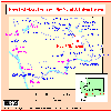 [Map,20K,InlineGIF]
Map, Major hydrologic features in the Mount St. Helens Region
-- Modified from Crandell and Mullineaux, 1978, USGS Bulletin 1383-C
From:
Wolfe and Pierson, 1995,
Volcanic-Hazard Zonation for Mount St. Helens, Washington, 1995:
USGS Open-File Report 95-497
-
A number of natural and human-made lakes exist close to the
volcano in the
North Fork Toutle and
Lewis River
valleys. The uppermost lake in the Lewis River valley,
Swift Reservoir,
receives drainage from the volcano via
Swift Creek,
Pine Creek, and
Muddy River.
In 1980,
lahars descending these streams
dumped about 14 million cubic meters (18 million cubic yards)
of sediment and water into the lake,
abruptly raising the lake level 0.85 meters (2.8 feet). Because the
operators of the reservoir, Pacific Power and Light, lowered the
lake level about 18 meters (23 feet) below normal in anticipation of
possible lahars, the small lake-level rise and the 0.4 meter (1.3 feet)
accompanying wave posed no threat to the dam. It is assumed that
(1) future lahars reaching Swift Reservoir would not be appreciably
larger than those of May 18, 1980, and (2) dam operators would again
take precautionary steps to lower lake level if Mount St. Helens
were to show signs of imminent eruption. Therefore,
Swift Reservoir and the downstream lakes
(Yale Lake and Lake Merwin) are
not considered to be at risk from lahars.
-
Three natural lakes in the
North Fork Toutle River,
formed by
natural debris dams
during the 1980 eruption, have required
modifications to their outlets in order to prevent catastrophic
outbreaks. The U.S. Army Corps of Engineers provided (1) a tunnel
outlet to
Spirit Lake,
(2) a bedrock spillway channel at
Coldwater Lake,
and (3) a reinforced spillway channel at
Castle Lake
to hold the levels of these lakes constant and to prevent them from
overtopping their erodible natural dams.
A recent study (Roeloffs, 1994), however, has verified earlier conclusions
that the natural dam at Castle Lake is potentially susceptible to modes
of failure other than overtopping and, under certain conditions, is only
marginally stable. Castle Lake contains about 23 million cubic meters
(30 million cubic yards) of water and would produce a large lahar if the
blockage were to fail. We assume that an outbreak of Castle Lake
is a potential hazard ...
-

-
MSH84_castle_lake_debris_avalanche_march_1984.jpg
The May 18, 1980 debris avalanche from Mount St. Helens covered over 24 square miles (62 square kilometers) of the upper Toutle River valley and blocked tributaries of the North Fork Toutle River. New lakes such as Castle Lake (pictured here) and Coldwater Lake were created.
USGS Photograph taken in March 1984 by Robert L. Schuster.
[medium size] ...
[large size]
From:
Washington Department of Fish and Wildlife Website, 2001
-
Castle Lake:
Located in the Mount St. Helens National Volcanic Monument,
Castle Lake requires a 20-plus mile drive over rough logging
roads, followed by a tough hike down a steep hillside to the lake.
The key to finding the lake is to first find the Weyerhaeuser 3000 road.
Would-be anglers not familiar with the area should get a St. Helens West hunting map,
published by the Washington Forest Protection
Association. Those who put forth the effort have a chance to catch dandy-size rainbow trout;
fish up to 10 pounds have been reported.
This is a self-sustaining fishery, with no fish planted, so selective gear rules are in effect,
along with a one-fish, 16-inch minimum size limit.
The lake is open year-round, but the road in is usually blocked by snow until at least May.
From:
Roeloffs, 1994,
An Updated Numerical Simulation of the Ground-Water Flow System for the Castle
Lake Debris Dam, Mount St. Helens, Washington, and Implications for Dam
Stability Against Heave: USGS Water-Resources Investigations Report 94-4075.
-
When
Mount St. Helens erupted in May, 1980, the
debris flow that swept down the
Toutle River
blocked South Fork Castle Creek, impounding Castle Lake. In order
to prevent the rising lake from overtopping the
debris dam,
a spillway was constructed in 1981 to stabilize the elevation of the lake, which
now contains approximately 19,000 acre-feet (acre-ft) of water. If the natural
dam were to fail, the ensuing breakout of Castle Lake might seriously
affect communities downstream along the Toutle River.
Although the dam and spillway have performed well to date, piezometers in the
dam reveal hydraulic heads 30 feet or more above lake level in the dam crest.
In this respect, the hydraulic head distribution in the natural dam does not
resemble that in a engineered embankment dam.
-
 MORE - Castle Lake Menu
-

-
MSH81_coldwater_lake_outlet_channel_10-17-81.jpg
Outlet channels were built at Castle Lake and Coldwater Lake (shown here) to stabilize water levels and prevent overtopping of the debris dams.
USGS Photograph taken in October 17, 1981, by Lyn Topinka.
[medium size] ...
[large size]
From:
Washington Department of Fish and Wildlife Website, 2001
-
Coldwater Lake (750 acres): Located in the Mount St. Helens National Volcanic Monument
off SR 504, Coldwater Lake was formed
by a debris dam resulting from the eruption of Mount St. Helens.
Skamania and Cowlitz counties share this lake, but the main
access is in Cowlitz County. Rainbow trout fingerlings stocked in the
late 1980s have grown to impressive size, and are
reproducing on their own. No additional planting is planned.
Cutthroat trout also inhabit the lake. Selective gear rules are in effect, with a
one-fish limit and 16-inch minimum size limit. Electric fishing motors are allowed.
Shoreline access is limited, but a boat launch, fish
cleaning station, and nature walk are available. The Forest Service
charges an access fee to use the Coldwater facility; contact the Forest
Service's Mount St. Helens monument headquarters (360/274-2131)
for more information. Although the lake is open to fishing all year,
access may not be available during winter. Disabled accessibility -
Level 2 at the boat ramp. WCT, Blk Tpa, steep ramp.
-
MORE - Coldwater Lake Menu
From:
Washington Department of Fish and Wildlife Website, 2001
-
Merrill Lake (344 acres): This fly-fishing-only lake is located north of Cougar near
Mount St. Helens. Merrill contains coastal cutthroat,
brown trout to several pounds, and some rainbow trout. Special bag and size limits are in effect; please check the regulations pamphlet.
Internal combustion engines are prohibited on boats that are used for fishing. Merrill is open year-round, but action is usually slow during
the winter months. There is a DNR campground and boat ramp.
-
MORE - Merrill Lake Menu
From: USGS Water-Data Report WA-97-1
-
Merwin Reservoir is formed by a combination gravity-concrete-arch dam.
Some storage began March 1931; completed May 13, 1931.
Usable capacity: 245,600 acre-feet
between elevations 165 feet (lower limit of regulation set by Federal Energy
Regulatory Comission), and 235 feet (top of spillway gates). Additional storage
of 18,200 acre-feet is provided by flashboards to elevation 239.6 feet. Unused
storage below elevation 165 fett: 159,000 acre-feet. Water is used by
PacifiCorp for power development.
Washington Department Fish and Wildlife Website, November, 1998
-
Merwin (Lake) Reservoir (4,090 acres): This North Fork Lewis River
impoundment located near the town of Ariel is shared by Clark and Cowlitz
counties, with 2,400 acres in Clark County and 1,690 in Cowlitz. Kokanee
are the main target. Angling is best in early spring, with fish in the
10-inch class. Small northern squawfish can be numerous and pesky. Tiger
muskies were planted in 1995 to help control squawfish populations. There
is a 36-inch minimum size limit on the muskies, which they will not reach
for several years. The lake is open to fishing year-round.
-
MORE - Merwin Reservoir Menu
From: Doukas, 1990, Road Guide to Volcanic Deposits of Mount St. Helens and Vicinity, Washington: U.S.Geological
Survey Bulletin 1859, 53p.
-
This site is within the May 18, 1980, blast zone, about 8.5 miles from the volcano;
to the northeast, the blast swept out
to a distance of 13 miles. A short trail leads from the road to Meta Lake,
an interesting path through downed timber, to
a lake that was only moderately disturbed by the blast. Small trees on the shore and fish in the lake survived because
they were under the snowpack. One blown-down tree near the start of
the trail shows tightly clustered rings for a few
years after A.D.1800 (the year when pumice of the T tephra was
erupted from Mount St. Helens).
-
A car damaged by the blast belonged to a family killed at their
small mine, on the ridge 1 1/2 miles to the west. Thick
tephra layers are exposed along USFS Road 99 from here to the
Windy Ridge parking lot.
-
MORE - Meta Lake Menu
From: Pringle, 1993, Roadside Geology of Mount St. Helens National Volcanic Monument and Vicinity: Washington
Department of Natural Resources,
Division of Geology and Earth Resources Information Circular 88
-
Ryan Lake Viewpoint and the 1/2-mile loop trail provide
a good overview of the effects and dynamics of the Mount
St. Helens May 18, 1980 blast at a point 12 miles north of the crater.
Research on the effects of heat on conifer needles
shows that the temperature of the blast at this site reached an
estimated 300 degrees C (572 degrees F).
As much as 6 inches of ash fell here. Two people died in this area on May
18, 1980, as a result of asphyxiation
caused by inhaling the ash. Another person somehow hiked nearly 10 miles
farther north and then succumbed, also to asphyxiation.
Notice that locally trees on the lower parts of the
valley wall have been blown down, whereas those on upper parts of
the valley wall still stand. By the time the blast
reached this location, particle segregation within it had created a heavier
"flow" phase, which blew down trees in lower areas,
and a lighter "surge" phase, which left trees standing in higher
areas.
-
Mount St. Helens tephra layers Y, W, and T crop out
in cuts along this trail. Rock of the Spirit Lake pluton was
quarried for road construction at a site on the south edge of the parking area.
-
MORE - Ryan Lake Menu
From: Pringle, 1993,
Roadside Geology of Mount St. Helens National Volcanic Monument and Vicinity:
Washington Department of Natural Resources
Division of Geology and Earth Resources Information Circular 88
-
Silver Lake is shallow (maximum depth about 16 feet or 5 meters)
and was formed and is
partially underlain by lahar deposits. About 2,500 years ago during the Pine
Creek eruptive period, a series of very large lahars traveled down the Toutle
River from Mount St. Helens. The lahars flowed into Outlet Creek (east of the
lake) and dammed its valley to produce Silver Lake. These lahars were generated
by the catastrophic draining of a lake (presumably an older Spirit Lake) or
lakes that had been dammed by debris avalanches from Mount St. Helens. The
level of Silver Lake is now controlled by a dam.
-
MORE - Silver Lake Menu
-

-
MSH80_blast_area_spirit_lake_with_rainier_10-04-80.jpg
Spirit Lake, once surrounded by lush forest, is within the area devastated by blast. Remnants of the forest float on the surface of the lake. Another Cascade volcano, Mount Rainier (14,410 feet [4,392 meters]), is in the distance. The view is from the south.
USGS Photograph taken on October 4, 1980, by Lyn Topinka.
[medium size] ...
[large size]
From:
Simon, 1999, Channel and Drainage-Basin Response of the Toutle River System in
the Aftermath of the 1980 Eruption of Mount St. Helens, Washington:
USGS Open-File Report 96-633
-
The
1980 eruptions of Mount St. Helens
in southwestern Washington marked the
re-awakening of a relatively young (40,000 years) volcano that had been dormant
since 1857. Frequent dacitic eruptions during the previous 2,500 years had
produced pyroclastic flows, ash falls, debris flows, lava domes, and lava flows
of andesite and basalt. Pyroclastic flows and lahars accompanied most eruptive
periods and were largely responsible for forming fans around the base of the
volcano, some of which dammed the North Fork Toutle River to form Spirit Lake
between 3,300 and 4,000 years ago.
From:
Brantley and Topinka, 1984, Volcanic Studies at the
U.S. Geological Survey's David A. Johnston Cascades Volcano Observatory,
Vancouver, Washington, Earthquake Information Bulletin, v.16, n.2,
March-April 1984
-
The debris avalanche that triggered the (Mount St. Helens May 18, 1980)
eruption slid north into Spirit Lake and west 25 kilometers down the
North Fork Toutle River valley,
covering the valley floor with unconsolidated debris to
an average depth of 45 meters and as much as 180 meters in some places. ...
The debris avalanche raised the level of Spirit Lake
64 meters and dammed its natural outlet even higher.
From:
Dion and Embrey, 1981,
Effects of Mount St. Helens Eruption on Selected Lakes in Washington:
USGS Circular 850-G
-
A comparison of aerial photographs taken before
and after the eruption shows that the lake increased in
size and rose in altitude. The surface area of the lake increased from 1,300
acres to about 2,200 acres. Soundings of the east bay of the lake on October
16, 1980, indicated that the depth at the midpoint of the east bay, originally
190 feet, was less than 50 feet. Because of an extensive
cover of logs on the surface of Spirit Lake, a post-eruption bathymetric map
could not be constructed. The rise in lake level, estimated to be about 240
feet, is due to the blockage of the North Fork Toutle River, floods from melting
snow on the volcano, and partial filling of the lake with debris (Youd and
Wilson, 1980). Because of the blockage of the original outlet, surface outflow
to North Fork Toutle River will not occur until the lake rises from its present
altitude of about 3,440 feet to about 3,600 feet. The pre-eruption altitude of
the lake was 2,198 feet.
-- From:
Meyer and Dodge, 1988, Post-Eruption Changes in Channel Geometry of
Streams in the Toutle River Drainage Basin, 1983-85, Mount St. Helens,
Washington: U.S. Geological Survey Open-File Report 87-549
-
In May 1985, a tunnel was opened connecting Spirit Lake and
South Coldwater Creek.
Water was released from Spirit Lake into South Coldwater Creek at
controlled rates of 5.7 cubic meters per second, 8.5 cubic meters per second,
11.3 cubic meters per second, and 14.2 cubic meters per second for approximately
one-week periods during May 1985. As the level of the lake approached the
tunnel gate elevation (1048.5 meters above NGVD of 1929)
during June through August
1985, tunnel discharge declined from about 11.3 cubic meters per second to less
than 5 cubic meters per second, the natural summer discharge from
Spirit Lake.
-
MORE - Spirit Lake Menu
-
MORE - St. Helens Lake Menu
From: USGS Water-Data Report WA-97-1
-
Swift Reservoir is formed by a rock and earthfill dam. Storage began
September 19, 1958; the dam was completed in December 1958. Usable capacity:
446,600 acre-feet between elevations 878 feet (lower limit for economic
operation), and 1,000.5 feet (maximum operating limit). Dead storage is unknown.
Water is used by PacifiCorp for power development.
From: Washington Department Fish and Wildlife Website
(http://www.wa.gov/wdfw/), November, 1998
-
Swift Reservoir (4590 acres): Large plants of fingerling rainbow trout
usually produce excellent trout fishing in this 10-mile-long reservoir on
the North Fork of the Lewis River. Watch local newspapers for reports on
fish survival. Improved water clarity will be a key to fishing success.
During April and May fish tend to congregate near the dam and around
streams entering the reservoir. By June, anglers should be able to catch
trout throughout the reservoir. A public boat launch is available. Call
Pacific Power and Light at 1-800-547-1501 for reservoir level information.
Remember that all bull trout/Dolly Varden must be released in this region.
Open season runs from the last Saturday in April through October 31.
-
MORE - Swift Reservoir Menu
From: USGS Water-Data Report WA-97-1
-
Yale Reservoir is formed by a rock and earthfill dam. Storage began July
31, 1952; the dam was completed in 1952. Usable capacity: 189,500 acre-feet
between elevations 430 feet (lower limit for economic operation), and 490 feet
(top of spillway gates). Dead storage below elevation 417 feet: 178,000
acre-feet. Water is used by PacifiCorp for power development.
From: Washington Department Fish and Wildlife Website
(http://www.wa.gov/wdfw/), November, 1998
-
Yale Reservoir (3,802 acres): This North Fork Lewis River reservoir has
2,023 acres in Clark County and 1,779 acres in Cowlitz County. Kokanee
fishing is the main attraction, but success this year will likely still be
down because of the severe winter flooding in 1996, and heavy rainfall and
snowpack in 1997. Shallow fishing for kokanee is best in the spring and
fall; in the summer, deep fishing is the rule. Some cutthroat trout are
caught near the mouth of Siouxon Creek, and Yale also has a few bull trout.
All bull trout and Dolly Varden must be released. Boat ramps are available
at Saddle Dam, Yale, Cougar Camp and Beaver Bay. The lake is open to
fishing year-round.
-
MORE - Yale Lake Menu
Return to:
[Mount St. Helens Menu] ...
[Mount St. Helens Lakes Menu] ...
[Volcanic Lakes Menu] ...

URL for CVO HomePage is:
<http://vulcan.wr.usgs.gov/home.html>
URL for this page is:
<http://vulcan.wr.usgs.gov/Volcanoes/MSH/Hydrology/Lakes/description_msh_lakes.html>
If you have questions or comments please contact:
<GS-CVO-WEB@usgs.gov>
11/18/04, Lyn Topinka


