
<< Go Back |
| Note 1: Commonly Used Variables |
|
PARENTS’ EDUCATION Parents’ level of education is generally measured by either the mother’s highest level of educational attainment or the highest level of education attained by either parent. Indicators 32, 33, 34, and 36, based on the National Household Education Surveys Program (NHES), use the highest level of education attained by either parent. For these indicators, both mother’s and father’s education was constructed using three questions: (1) on the highest grade completed, (2) whether he or she obtained a vocational or technical degree after high school, and (3) whether he or she obtained a high school equivalency degree if he or she had not completed high school. Indicators 12 and 13 report parents’ highest level of education based on a question in the National Assessment of Educational Progress (NAEP) that asked students in 8th and 12th grades to indicate the highest level of education completed by each parent. Students could choose from “did not finish high school,” “graduated from high school,” “some education after high school,” “graduated from college,” and “I don’t know.” As of the 2001 assessment, data were not collected at grade 4 because 4th-graders’ responses in previous assessments were highly variable and contained a large percentage of “I don’t know” responses. RACE/ETHNICITY Classifications indicating racial/ethnic heritage are based primarily on the respondent’s self-identification, as is the case with data collected by the U.S. Census Bureau, or, in rare instances, on observer identification. These categories are in accordance with the Office of Management and Budget’s standard classification scheme. Ethnicity is based on the following categorization:
Race is based on the following categorization:
Not all categories are shown in all indicators. In some cases, this is because there are insufficient data in some of the smaller categories or because survey sampling plans did not distinguish between groups, such as Asians and Pacific Islanders. In other cases, this occurs because only comparable data categories are shown. For example, the category “More than one race,” which was introduced in the 2000 Census and became a regular category for data collection in the Current Population Survey (CPS) in 2003, is sometimes excluded in indicators that present a historical series of data with constant categories, or else it is included within the category “Other.” The introduction of the category “More than one race” follows a change in the Office of Management and Budget’s standard classification scheme for race/ethnicity. This change has required changes in the questions asked by the CPS, and it will require further changes in the questions asked of future federal survey participants. As a result of the new classification scheme, distributions by race/ethnicity for 2003 CPS data and for later years may differ somewhat from earlier years. In the Census population estimates for July 1, 2003, about 1.5 percent of the national population were classified as “More than one race.” (For further details, see http://www.census.gov/popest/national/asrh/NC-EST2003-srh.html.) In The Condition of Education 2006, these definitions of race/ethnicity apply to indicators 5, 6, 7, 8, 10, 12, 13, 14, 15, 18, 19, 21, 22, 23, 24, 25, 26, 27, 28, 29, 31, 32, 37, and 39. Indicators based on the National Household Education Surveys Program (indicators 2, 11, 33, 34, 36, and 38) use up to five categories of race/ethnicity: White, non-Hispanic; Black, non-Hispanic; Hispanic; Asian or Pacific Islander, non-Hispanic; and all other races, non-Hispanic. The latter category includes American Indian, Alaska Native, and all other races. Not all categories are shown in all indicators because of insufficient data in some of the smaller categories. COMMUNITY TYPE There are various classification systems that federal departments and agencies use to define community types. Indicators in The Condition of Education rely on one or a combination of the following three classification systems: the Office of Management and Budget’s system of metropolitan areas, which is used by the Census Bureau; the Census Bureau’s system of urbanized/urban/rural areas; and the National Center for Education Statistics’ system of locale codes. All three of these classification systems were revised in 2000 and were fully in effect by 2002. Metropolitan Areas The Census Bureau’s Current Population Survey (CPS) classifies community type based on the concept of a metropolitan area, which has changed in its application over time. Between 1990 and 2000, the Census and the CPS used the term “metropolitan area” (MA) to refer collectively to Metropolitan Statistical Areas (MSAs), Primary Metropolitan Statistical Areas (PMSAs), and Consolidated Metropolitan Statistical Areas (CMSAs) (defined below). In 2000, the Census adopted the term “Core Based Statistical Area” (CBSA), which refers collectively to metropolitan statistical areas and (the newly introduced concept of) micropolitan statistical areas. Metropolitan Areas—1990 Standards The Office of Management and Budget (OMB) defines and designates metropolitan areas, following standards established by the interagency Federal Executive Committee on Metropolitan Areas, with the aim of producing definitions that are as consistent as possible for all MAs nationwide. Under its 1990 standards, the OMB defined an MA as “a large population nucleus together with adjacent communities that have a high degree of economic and social integration with that core.” The Census Bureau used this definition for an MA from 1990 to 2000. (See http://www.census.gov/prod/cen1990/cph-s/cph-s-1-1.pdf for more details.) In order to be designated as an MA under the 1990 standards, an area had to meet one or both of the following criteria: (1) include a city with a population of at least 50,000 or (2) include a Census Bureau-defined urbanized area of at least 50,000 and have a total MA population of at least 100,000 (75,000 in New England). Under the 1990 standards, the “central county” (or counties) contained either the central city (defined below) or at least 50 percent of the population of the central city, or had at least 50 percent of its population in an urbanized area. Additional “outlying counties” were included in the MA if they met specified requirements of commuting to the central counties and selected requirements of metropolitan character (such as population density and percent urban). In New England, MAs were defined in terms of cities and towns, following rules analogous to those used with counties elsewhere. The individual counties (or other geographic entities) comprising each MA were either designated as a Metropolitan Statistical Area (MSA) or, if the MA was large enough (1 million in population or more), as a Consolidated Metropolitan Statistical Area (CMSA) composed of two or more Primary Metropolitan Statistical Areas (PMSAs). For example, the PMSA “Milwaukee-Waukesha, WI” combined with the PMSA “Racine, WI” to form the CMSA of “Milwaukee-Racine, WI.” CMSAs could span states, as was the case with the CMSA “Philadelphia-Wilmington-Atlantic City, PA-NJ-DE-MD.” (In June 1999, there were 258 MSAs and 18 CMSAs in the United States, which included a total of 73 PMSAs.) All territory, population, and housing units inside of MAs were characterized as metropolitan. Any territory, population, or housing units located outside of an MA was defined as nonmetropolitan. The largest city in each MA was designated a central city, and additional cities could qualify as such if specified requirements were met concerning population size and commuting patterns. (In June 1999, there were 542 central cities in the United States plus 12 in Puerto Rico.) Together these classifications were used to define a location’s MA Status as
This classification scheme for community type is used by the School Crime Supplement to the National Crime Victimization Survey (NCVS) (U.S. Department of Justice, Bureau of Justice Statistics); however, the community type labels differ. NCVS uses the following labels to identify the community type of its respondents’ home residence:
In The Condition of Education 2006, no indicators use these labels and definitions. Metropolitan and Micropolitan Statistical Areas—2000 Standards In 2000, the OMB defined metropolitan and micropolitan statistical areas as “a core area containing a substantial population nucleus, together with adjacent communities having a high degree of economic and social integration with that core.” Together metropolitan and micropolitan statistical areas are considered to constitute the “Core Based Statistical Area” (CBSA). Currently defined metropolitan and micropolitan statistical areas are based on the application of OMB’s 2000 standards to 2000 decennial census data. (Current metropolitan and micropolitan statistical area definitions were announced by OMB effective June 6, 2003.) In order to be designated as a CBSA under the 2000 standards, an area must contain at least one “urban” area (that is, an urbanized area or urban cluster—see definitions of urbanized area and urban cluster below) with a population of 10,000 or more. Each metropolitan statistical area—now referred to as a “metro area” to distinguish it from the metropolitan statistical areas referred to as “MSAs” under the 1990 standards—must have at least one urbanized area of 50,000 or more inhabitants. Each micropolitan statistical area must have at least one urban cluster of at least 10,000 but less than 50,000 population. Under the standards, the county (or counties) in which at least 50 percent of the population resides within urban areas of 10,000 or more population, or that contains at least 5,000 people residing within a single urban area of 10,000 or more population, is identified as a “central county” (counties). Additional “outlying counties” are included in the CBSA if they meet specified requirements of commuting to or from the central counties. Counties or equivalent entities form the geographic “building blocks” for metropolitan and micropolitan statistical areas throughout the United States and Puerto Rico. (As of June 6, 2000, there were 362 metropolitan statistical areas and 560 micropolitan statistical areas in the United States. In addition, there were eight metro areas and five micropolitan statistical areas in Puerto Rico.) (See http://www.census.gov/population/www/estimates/aboutmetro.html for more details.) Together these classifications are used to define a location’s CBSA status (or, if no micropolitan statistical areas are included, metro area status) as
As with the previous MA status classifications under the 1990 standards, the CBSA status under the 2000 standards do not equate to an urban-rural classification; all counties included in metropolitan and micropolitan statistical areas (and many other counties) contain both. In The Condition of Education 2006, no indicators use these labels and definitions. However, some indicators use the NCES 2002-revised locale codes that are based on the metro area labels and definitions. Urbanized, Urban, and Rural Areas The Census Bureau divides the entire geographic area of the United States, Puerto Rico, and the Island Areas according to a concept of urban and rural areas. As with metropolitan statistical areas, the Census Bureau revised the urban/rural concept and criteria for the 2000 Census. The criteria in place between 1990 and 2000, however, were used to create NCES locale codes (described below). Thus, this supplemental note explains the 1990–2000 criteria in detail for readers to understand fully the locale code definitions. From the adoption of the urban/rural concept for the 1950 Census until the 2000 Census, an urbanized area consisted of one or more “central places” and the adjacent densely settled surrounding “urban fringe” that together had a minimum population of 50,000 people. A “place” was either an incorporated governmental unit, such as a city, village, borough, or town, or a Census Designated Place (CDP), which was an unincorporated population cluster for which the Census Bureau delineates boundaries in cooperation with state and local agencies. All of the territory within the urbanized area that was outside the central place or places comprised the “urban fringe.” Territory included in the urban fringe generally had a population density of at least 1,000 people per square mile but could include lower density territory that contained nonresidential urban land uses (e.g., areas zoned for commercial or industrial use or reserved for recreational purposes) or served to link outlying densely settled territory with the main body of the urbanized area. The Census Bureau defined as urban any incorporated places (cities, towns, villages, etc.) or CDPs outside urbanized areas that contained a population of 2,500 or more. The Census Bureau also expanded the definition of places to include extended cities. Extended cities were incorporated places whose boundaries encompassed substantial amounts of low-density territory (less than 100 people per square mile), relative to the overall land area of the place. The Census Bureau then identified both urban and rural territory in such places, thus providing exceptions to the general rule that places were classified as entirely urban or entirely rural. There were 182 extended cities in 1990. The decision to ignore place boundaries when defining urban areas for the 2000 Census (see below) made the extended city concept obsolete; under the 2000 criteria, any place potentially can be divided into urban and rural components. No survey employed in this volume of The Condition of Education includes extended cities in its community type definition. The Census Bureau then classified all territory, population, and housing units not classified as urbanized or urban as rural. (For further details, see http://www.census.gov/population/censusdata/urdef.txt.) Beginning with the 2000 Census, the Census Bureau has employed new definitions of urban areas based on the concepts of an urbanized area and an urban cluster, the former being similar to the urbanized area under the 1990 definitions and the latter replacing the concept of urban fringe and urban areas. Urbanized areas and urban clusters consist of densely settled census block groups and census blocks that meet specified minimum population density requirements. Urbanized areas continue to have minimum populations of 50,000; urban clusters have populations of at least 2,500 and less than 50,000. Place boundaries are no longer taken into consideration when defining these two types of urban areas. (Under the previous classification system, place boundaries were used to determine the urban/rural classifications of territory: all incorporated places that had at least 2,500 people were classified as urban if they were outside an urbanized area.) Thus, the Census Bureau’s current urban area classification provides a seamless, nationally consistent method of defining urban areas that is not affected by varying state laws governing incorporation and annexation. For further details on the revised definitions, see http://www.census.gov/geo/www/ua/ua_2k.pdf. (For differences between the 1990 Census and 2000 Census Urbanized Area Criteria, see http://www.census.gov/geo/www/ua/uac2k_90.html.) In The Condition of Education 2006, indicators 36 and 39 use these labels and definitions. Locale Code In the NCES Common Core of Data (CCD), the community type of schools is classified according to a “Locale Code” that is defined according to a mix of OMB (metropolitan area) and Census Bureau (urban/rural) classifications. There are eight categories within the school locale code classification: (1) large city; (2) midsize city; (3) urban fringe of a large city; (4) urban fringe of a midsize city; (5) large town; (6) small town; (7) nonmetropolitan rural; and (8) metropolitan rural. These categories roughly equate to a central city/suburb/large town/small town/rural scheme, identifying the general character of each school’s location. “Large city” and “midsize city” schools are located in principal cities (formerly referred to as “central cities”) of metropolitan statistical areas, with a threshold of 250,000 people distinguishing between a large city and a midsize city. The two “urban fringe” categories identify suburban schools within metropolitan statistical areas. The “large town” and “small town” categories identify schools in smaller urban centers (25,000 up to 50,000 people) and small towns (2,500 up to 25,000 people) that are located outside metropolitan areas; many of these communities represent the urban centers/small towns that serve a largely rural countryside. The two rural categories recognize that rural territory exists in both metropolitan areas and nonmetropolitan territory. Each school is assigned to one of these categories based on the inside/outside principal city, urban/rural, and metropolitan/nonmetropolitan status of the census block in which the school is located. Schools are assigned to specific census blocks through a process called “geocoding” in which the address of the school is mapped in relation to census geography. The associated census geographic information is then used to assign the school to a specific locale code category based on a mix of characteristics. For instance, a school located in a Census Bureau-defined urbanized area (that is, inside an OMB-defined metropolitan statistical area and outside of a principal city) would be classified as an “urban fringe” school; the specific urban fringe category is determined by the population size of the largest principal city in the metropolitan statistical area in which the school is located. Likewise, a school located outside a Census Bureau-defined “urban” area (urbanized or urban area; or urbanized area or urban cluster, depending upon the relevant standards—1990 or 2000) is classified as rural; then it is further distinguished by whether it is inside or outside the boundaries of a metropolitan statistical area. In the context of assigning school locale codes, it is important to note that a school located in a Census Bureau-defined urban area that is inside the boundaries of a metropolitan statistical area will be classified as “urban fringe” regardless of the distance from the large or midsize city with which it is associated. Further, if a school does not provide NCES with an address that can be geocoded to a specific census block (such as a P.O. Box or rural route/box number types of addresses) and clerical research cannot determine the specific location of the school in terms of Census Bureau geography, the locale code assignment process assigns the school an “urban fringe” code if the school is located in a metropolitan statistical area. School district locale codes are assigned through the use of these school locale codes, according to classification rules, such as the following: if 50 percent or more of students in the district attend schools that are located in a single locale code, that code is assigned to the district. If not, schools are placed into one of three groups: large or midsize city; urban fringe or rural, inside an MA (or metro area); and large town, small town, or rural, outside an MA (or metro area). The group with the largest number of students is determined, and then the locale code within the group having the largest number of students is assigned to the district. If the number of students between two or more groups is the same, then the least urban locale code is assigned. Districts with no schools or students are given a locale code of “N.” (For more information on the Locale Code, download the “General” Documentation for the school year of interest from the Common Core of Data (CCD) Universe Survey Dataset webpage at http://nces.ed.gov/ccd/pubschuniv.asp, then search the document for occurrences of “Locale Code.”) Besides being used for the CCD, the eight-level locale codes are used to categorize community type in other NCES surveys. Typically, however, the locale codes are collapsed into three categories. For example, in the National Assessment of Educational Progress (NAEP) and the Schools and Staffing Survey (SASS), the community type of a school is categorized according to its address as follows:
In The Condition of Education 2006, these labels under the 2000 standards apply to indicator 6, and these labels under the 1990 standards for pre-2002–03 data and under the 2000 standards for 2002–03 (and subsequent) data apply to indicators 4, 12, and 15. POVERTY Data on household income and the number of people living in the household are combined with estimates of the poverty threshold published by the Bureau of the Census to classify children (or adults) as “poor” or “nonpoor” in indicator 2. Children (or adults) in families whose incomes are at or below the poverty threshold are classified as poor; those in families with incomes above the poverty threshold are classified as nonpoor. The thresholds used to determine whether an individual is poor or nonpoor differ for each survey year. The weighted average poverty thresholds for various household sizes for 1990, 1994, 1998, 1999, 2000, 2001, 2002, 2003, and 2004 are shown in the table on the next page. (For thresholds for other years, see http://www.census.gov/hhes/www/poverty/threshld.html.) Indicators 7, 20, 21, 33, 34, 36, and 38 modify the categories of poverty, to include the “poor,” “near-poor,” and “nonpoor.” Poor is defined to include those families below the poverty threshold, near-poor is defined as those at 100–199 percent of the poverty threshold, and nonpoor is defined as 200 percent or more than the poverty threshold. Eligibility for the National School Lunch Program also serves as a measure of poverty status. The National School Lunch Program is a federally assisted meal program operated in public and private nonprofit schools and residential child care centers. Unlike the poverty thresholds discussed above, which rely on dollar amounts determined by the Census Bureau, eligibility for the National School Lunch Program relies on the federal income poverty guidelines of the Department of Health and Human Services. To be eligible for free lunch, a student must be from a household with an income at or below 130 percent of the federal poverty guideline; to be eligible for reduced-price lunch, a student must be from a household with an income at or below 185 percent of the federal poverty guideline. Title I basic program funding relies on free lunch eligibility numbers as one (of four) possible poverty measures for levels of Title I federal funding. In The Condition of Education 2006, eligibility for the National School Lunch Program applies to indicator 24. Small Area Income and Poverty Estimates (SAIPE) Program The goal of the Census Bureau’s Small Area Income and Poverty Estimates (SAIPE) program is to make intercensal estimates of median income and numbers in poverty for states, counties, and school districts. Indicator 41 employs SAIPE’s school district estimates of the population of children ages 5–17 and the number of related children ages 5–17 in families in poverty. Indicator 41 also employs the SAIPE data rather than the free lunch eligible data to measure poverty by school district because SAIPE data are available for all regular operating school districts, while free lunch eligible data are missing for a sizeable number of school districts. Further, the SAIPE poverty data are constructed using consistent methodology while the designation of who is free lunch eligible may differ from school to school. More information about SAIPE is available at http://www.census.gov/hhes/www/saipe/. Geographic Region The regional classification system presented below represents the four geographical regions of the United States as defined by the Census Bureau of the U.S. Department of Commerce. In The Condition of Education 2006, indicators 3, 4, 5, 7, 25, 36, 42, and 44 use the Census Bureau system. |
Locale Codes 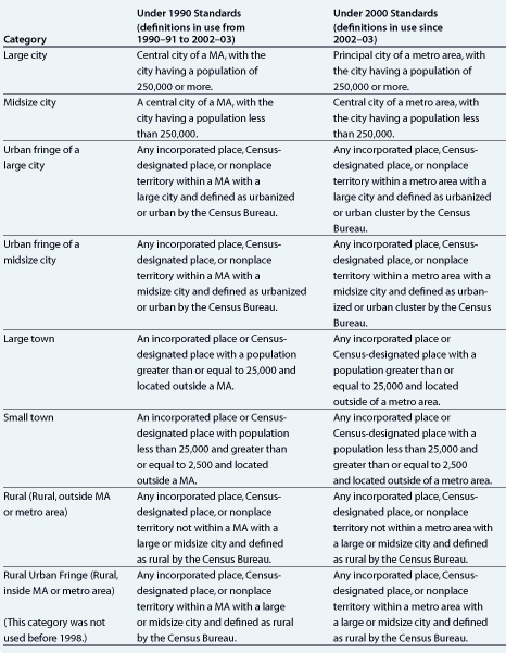 |
|
Weighted average poverty thresholds, by household size: Selected years, 1990–2004 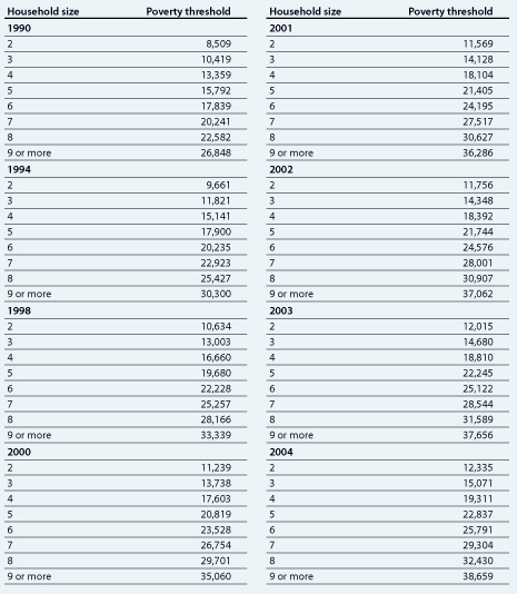 NOTE: Poverty thresholds for 1990, 1994, 1998, and 2000 were last revised August 22, 2002; poverty thresholds for 2001 were last revised September 24, 2002; poverty thresholds for 2002 were last revised June 22, 2004; poverty thresholds for 2003 were last revised August 26, 2004; and poverty thresholds for 2004 were last revised March 9, 2006. SOURCE: U.S. Department of Education, NCES. National Household Education Surveys Program (NHES), 1991, 1993, 1995, 1996, 1999, and 2001. |
U.S. Census Bureau, Regional Classification 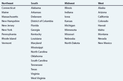 |
|
|
