
NOAA Hydrometeorological Testbed
HMT-West 2008 Operations
Recent HMT-West Highlight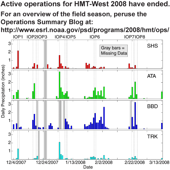
|
 |
| Figure 1. Folsom Dam built on the American River near Sacramento in 1955 impounds up to 1 million acre-feet of water. |
 |
| Figure 2. Basin scale HMT-West 2008 map. |
 |
| Figure 3. Regional scale HMT-West 2008 map. |
Participants
- NOAA Earth System Research Laboratory
(Physical Sciences Division and Global Systems Division) - NOAA National Severe Storms Laboratory
- NOAA Office of Hydrologic Development
- NOAA National Centers for Environmental Prediction
- NOAA National Weather Service - Western Region
- WFO's Sacramento, Reno, Monterey
- NOAA California-Nevada River Forecast Center
- Regional Headquarters
- CIRES - University of Colorado
- CIMMS - University of Oklahoma
- California Department of Water Resources
- Scripps Institute
- U.S. Geological Survey
- Western Regional Climate Center
Background
NOAA's Hydrometeorological Testbed (HMT) is a demonstration program that focuses the use of advanced observational and modeling tools on quantitative precipitation estimation (QPE) and quantitative precipitation forecasting (QPF) for the purpose of improving hydrologic forecasts and warnings. The testbed approach will accelerate transitions from the research and development community to operations, as described in NOAA's Strategic Plan and recommended by the NOAA Hydrology Team's Science and Technology Infusion Plan (STIP) and the U.S. Weather Research Program (USWRP).
The first two full-scale deployments of HMT occurred during the winters of 2005-2006 (HMT-West 2006) and 2006-2007 (HMT-West 2007) and were focused on the North Fork of the American River Basin located between Sacramento and Reno on the western slopes of the Sierra Nevada. Water from the American River Basin is a critical resource for California's economy and natural ecosystems, and the threat of flooding poses an extremely serious concern for the heavily populated downstream area (Figure 1). The frequent impact of prolonged, heavy winter precipitation from concentrated "atmospheric rivers" of moisture, originating in the tropical Pacific, underscores the area's flood vulnerability.
HMT-West 2008 Field Operations
Field operations will return to the American River Basin area during the winter of 2007-2008 for HMT-West 2008. Figure 2 shows the locations of instruments to be deployed for this effort. Most will operate from December 2007 through March 2008. A wide range of remote and in situ sensors will be deployed to accomplish this task. One of the most significant enhancements to HMT-West 2008 instrumentation compared to previous seasons is the addition of several new precipitation and soil moisture measurement sites at high elevation. Remote sensing instrumentation includes a scanning polarimetric radar, several wind profiling and precipitation profiling radars and a network of GPS receivers for measuring precipitable water vapor. Precipitation gauges and disdrometers, surface meteorological stations, soil moisture/temperature probes, snow depth sensors and stream level loggers are among the in situ sensors that will be deployed. In addition, rawinsondes will be released serially immediately upwind of the area during storm episodes.
These special, highly detailed observations will be collected within the wider scale context of the operational observing networks of the National Weather Service (NWS) and other agencies (Figure 3). In addition to their regular rawinsonde releases, the NWS will release supplemental rawinsondes near the coast and in the lee of the Sierra Nevada during selected storm episodes. Ongoing observations in the Russian River watershed of California's Coast Range for NOAA's Weather-Climate Connection project will complement the HMT measurements. Similar or expanded HMT deployments are expected in the same area for each of the following few winters. Table 1 lists the instrument types and their location coordinates.
Data from HMT and operational sources will be merged in algorithms with the intent to produce multi-sensor (e.g., radar + gauge) estimates of precipitation. These blended estimates overcome deficiencies inherent in estimates based on single instrument types. Equally important, demonstrations and evaluations of precipitation forecast improvements will be conducted for the American River Basin using high-resolution numerical prediction models, now in use as research tools.
In addition to the ongoing evaluation of the practical usefulness of the various new observing and model tools, specific HMT-West 2008 research objectives include:
- Attaining accurate QPE over the basin with high spatial resolution.
- Demonstrate new high-resolution forecast models and model ensembles for QPF tailored to the HMT area.
- Accurately mapping the height of the melting layer and monitoring its evolution.
- Improving the understanding of orographically influenced winter storm airflow and precipitation development processes.
- Demonstrate the concept of a regional HMT as a conduit to infuse new science and technology into operations.
- Test and evaluate different in situ precipitation measurement devices for use in future HMT efforts that will deal with mixed precipitation.
- Conduct water isotope measurements to study precipitation development processes.