
USGS/Cascades Volcano Observatory, Vancouver, Washington
DESCRIPTION:
Mount Hood Glaciers and Glaciations
- Mount Hood Glaciers and Glaciations
- Mount Hood Jökulhlaups
- Fraser Glaciation
- Mount Hood Glaciers
- Coe
- Coleman
- Eliot
- Ladd
- Langille
- Newton-Clark
- Palmer
- Reid
- Sandy
- White River
- ZigZag
|
Mount Hood Glaciers and Glaciations
|
-
 [Graphic,12K,GIF]
Simplified Map - Glaciers of Mount Hood, Oregon
-- Modified from: Swanson, et.al., 1989, AGU T106
From:
Swanson, et.al., 1989,
IGC Field Trip T106: Cenozoic Volcanism in the Cascade Range and
Columbia Plateau, Southern Washington and Northernmost Oregon:
American Geophysical Union Field Trip Guidebook T106, p.19-20.
-
Twelve glaciers and named snowfields
cover approximately 80 percent of the cone
above the 2,100-meter level and contain about 0.35 cubic kilometers of ice
(Driedger and Kennard, 1986).
Most of the glaciers have remained roughly constant in size over the last few
decades, after retreating from a neo-glacial maximum early in the 18th century
(Lawrence, 1948).
-
Modern glacier termini are at about 2,100 meters, but in the last major alpine
glaciation
(
Fraser, about 29-10 thousand years ago)
glaciers reached the 700-800 meter level.
During this time, ice spread 15 kilometers from the summit area (Crandell, 1980).
-
Lacustrine siltstone from near-terminus periglacial lakes plaster valley walls
just upstream from the mouth of Polallie Creek
on the east side of the mountain.
Highway 35 crosses White River
near the maximum extent of Fraser ice, and the
left-lateral moraine is prominent just upstream from the bridge. The full
extent of the Fraser-age glaciers has not been accurately mapped.
-
Glacier retreat released large volumes of outwash, some of which filled the
ancestral Hood River Valley near Parkdale, forming the flat surfaces of
Upper Hood River Valley and Dee Flat. Outwash also formed a
debris fan in the upper East Fork Hood River.
-
Evidence of older glaciation is seen in roadcuts on the southeast side of the
volcano and in rolling morainal landscape near Brightwood west of the
volcano. The deposits are not dated but may be coeval with the Hayden Creek
Drift near Mount Rainier (Crandell, 1980), probably about 0.14
million years ago (Colman and Pierce, 1981). ...
-
Jökulhlaups (glacial-outburst floods)
have been recorded from the
Zigzag,
Ladd,
Coe, and
White River Glaciers.
-
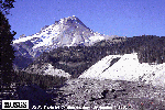 [Image,54K,JPG]
Mount Hood and White River Drainage, with 1998 Flow Deposits
-- USGS Photo by Cynthia Gardner, September 4, 1998
From:
Swanson, et.al., 1989,
IGC Field Trip T106: Cenozoic Volcanism in the Cascade Range and
Columbia Plateau, Southern Washington and Northernmost Oregon:
American Geophysical Union Field Trip Guidebook T106
-
Jökulhlaups (glacial-outburst floods)
have been recorded from the
Zigzag,
Ladd,
Coe, and
White River Glaciers.
In 1922, a dark debris flow issued from a
crevasse high on Zigzag Glacier and moved 650 meters
over the ice before entering
another crevasse; this event initiated a scare that Mount Hood was erupting
(Conway, 1921).
The Ladd Glacier jökulhlaup in 1961 destroyed sections of the
road around the west side of the mountain and partly undermined a tower of a
major powerline (Birch, 1961).
The Coe Glacier outburst occurred around 1963,
causing a section of trail to be abandoned
and the "round-the-mountain" trail to
be rerouted farther from the glacier.
Jökulhlaups from
White River Glacier
were reported in 1926, 1931, 1946, 1949, 1959, and 1968;
the Highway 35 bridge over
the White River was destroyed during each episode. The more frequent outbursts
from White River Glacier
may be due in part to an increase in size of the fumarole field at the head of the glacier at
Crater Rock (Cameron, 1988).
From:
Scott, et.al., 1997,
Geologic History of Mount Hood Volcano, Oregon -- A Field-Trip Guidebook:
USGS Open-File Report 97-263
-
Outburst floods from White River Glacier
have taken out numerous, lesser versions of the
highway bridge. The aggrading valley floor downstream displays several surfaces
formed during this century that can be differentiated by the size (age) of the
trees growing on them. The sediment sources for the aggradation are White
River Glacier and the canyons that are being cut into diamicts of Polallie
and Old Maid age downstream from White River Glacier
From:
Scott, et.al., 1997,
Volcano Hazards in the Mount Hood Region, Oregon:
USGS Open-File Report 97-89
-
During noneruptive periods, relatively small
lahars
present a hazard along channels and on
floodplains on the flanks of Mount Hood. Although of
modest size compared to lahars generated by eruptions
or large debris avalanches, they occur much more
frequently. Twenty-one lahars, including single flows
as large as several hundred thousand cubic meters
(cubic yards), whose effects were chiefly limited to
areas within 15 kilometers (9 miles) of Mount Hoods
summit, are reported in the historical record. Most
occurred during autumn and early winter rains.
Glacial outburst floods
caused at least two and probably as many as seven others.
From:
Crandell, 1980,
Recent Eruptive History of Mount Hood, Oregon,
and Potential Hazards from Future Eruptions:
USGS Bulletin 1492
-
The extent of glaciers during the last major glaciation is pertinent to the
eruptive history of Mount Hood
because the presence of glacier ice was partly
responsible for the distribution of volcanic deposits formed during the
first eruptive period ...
-
The last major advance of glaciers in Washington and British Columbia occurred
during the
Fraser Glaciation.
This glaciation began some time before about
29,000 years ago and ended about 10,000 years ago (Armstrong and others, 1965;
Armstrong and Clague, 1977). By comparison with glaciers in western Washington
and British Columbia, those at Mount Hood probably reached their maximum
downvalley extents by 18,000 years ago and then generally retreated until about
11,000 years ago. Glaciers in the mountains probably were not significantly
larger by that time than they are today.
-
Deposits of the Fraser Glaciation at Mount Hood can be recognized by
yellowish-brown soil oxidation and by a lack of appreciable weathering of stones
in soil profiles. The tickness of the oxidized zone on till measured at 17
localities ranged from 35 to 80 centimeters and averaged 63 centimeters. These
characteristics are similar to those of deposits of the first eruptive period
(Polallie) ... Some Polallie deposits, in fact, resemble
those of glacial origin because of their coarse, poorly sorted, or unsorted
texture. For example, deposits in roadcuts along U.S.Highway 26 about 3
kilometers west of Government Camp resemble till, but they were formed by
volcanic mudflows.
Similar mudflow deposits on the northeast side of Mount Hood have obscured the
extent of glacial deposits of Fraser age, thus, the extent of glaciers is not
known in that area.
-
The average altitude of north-facing cirques near Mount Hood is about 1,030
meter (3,400 feet) in the areas north and northwest of the volcano, about 1,250
meters (4,100 feet) south of the volcano, and about 1,370 meters (4,500 feet) to
the east. These cirque floors provide a crude measure of the altitude of areas
of ice accumulation during the last glaciation; however, the lower limits of
accumulation in areas outside cirques must have been higher because ice was not
as protected from the sun there as in the cirques.
-
When Fraser glaciers were at their maximum extents, the northern slopes of Mount
Hood probably were largely covered by ice at altitudes about 1,370 meters
(4,500 feet), and the southern slopes above perhaps 1,525-1,675 meters
(5,000-5,500 feet).
Most north-facing glaciers today terminate at altitudes of 1,830-1,980 meters
(6,000-6,500 feet), and the lower limits of perennial snow on the south slope of
the volcano seem to be at about 2,150 meters (7,000 feet).
-
Deposits of one or more older glaciations have also been recognized at scattered
localities in the Mount Hood area. One such deposit is till that forms a
terminal moraine in the Sandy river valley near Brightwood;
this moraine probably represents the farthest downvalley extent of a glacier
during the glaciation that immediately preceded the Fraser Glaciation.
Yellowish-brown soil oxidation extends to a depth of 1.5-2 meters in the till,
and stones in the soil profile have weathered rinds 1-2 millimeters thick.
Glacial deposits in the Mount Rainier area of Washington that have similar
weathering characteristics were assigned to the Hayden Creek Drift of the Salmon
Springs Glaciation (Crandell and Miller, 1974).
-
Till thought to be of Hayden Creek age elsewhere in the Sandy River valley
underlies a deposit of distinctive pumice that was erupted at Mount St. Helens
in southern Washington between about 35,000 and 40,000 years ago
(D.R.Mullineaux, oral commun., 1976). The best outcrop at which the relation of
the till to the pumice can be seen is along a road to a rock quarry south of
U.S.Highway 26.
-
At Bennett Pass, on the southeast side of Mount Hood, a large cut along State
Highway 35 exposes three tills separated by yellowish-brown oxidized zones that
constitute buried soils. The uppermost till forms a lateral moraine of Fraser
age; the ages of the underlying tills are not known.
-
[Graphic,12K,GIF]
Simplified Map - Glaciers of Mount Hood, Oregon
-- Modified from: Swanson, et.al., 1989, AGU T106
-
North side of Mount Hood
From: Swanson, et.al., 1989, IGC Field Trip T106
-
Jökulhlaups (glacial-outburst floods)
have been recorded from the
Zigzag,
Ladd,
Coe, and
White River Glaciers. ...
The Coe Glacier outburst occurred around 1963,
causing a section of trail to be abandoned
and the "round-the-mountain" trail to
be rerouted farther from the glacier.
-
Summit Glacier
-
Northeast side of Mount Hood
-
Northwest side of Mount Hood
From: Swanson, et.al., 1989, IGC Field Trip T106
-
Jökulhlaups (glacial-outburst floods)
have been recorded from the
Zigzag,
Ladd,
Coe, and
White River Glaciers. ...
The Ladd Glacier jökulhlaup in
1961 destroyed sections of the road around the west side of the mountain and partly undermined a tower of a major
powerline (Birch, 1961).
-
North-northeast side of Mount Hood
-
East side Mount Hood
-
South side of Mount Hood
-
West side of Mount Hood
-
West side of Mount Hood
-
South side of Mount Hood
From: Swanson, et.al., 1989, IGC Field Trip T106
-
Jökulhlaups (glacial-outburst floods)
have been recorded from the
Zigzag,
Ladd,
Coe, and
White River Glaciers. ...
Jökulhlaups from White River Glacier were reported in
1926, 1931, 1946, 1949, 1959, and 1968; the Highway 35 bridge
over the White River was destroyed during each episode.
The more frequent outbursts from White River Glacier may be
due in part to an increase in size of the fumarole field at the
head of the glacier at Crater Rock (Cameron, 1988).
-
Southwest side of Mount Hood
From: Swanson, et.al., 1989, IGC Field Trip T106
-
Jökulhlaups (glacial-outburst floods)
have been recorded from the
Zigzag,
Ladd,
Coe, and
White River Glaciers.
In 1922,
a dark debris flow issued from a crevasse high on Zigzag Glacier and
moved 650 meters over the ice before entering
another crevasse; this event initiated a scare that
Mount Hood was erupting (Conway, 1921).
Return to:
[Mount Hood Glaciers and Glaciations Menu] ...
[Mount Hood Volcano Menu] ...
[Glaciers and Glaciations Menu] ...

URL for CVO HomePage is:
<http://vulcan.wr.usgs.gov/home.html>
URL for this page is:
<http://vulcan.wr.usgs.gov/Volcanoes/Hood/Glaciers/description_hood_glaciation.html>
If you have questions or comments please contact:
<GS-CVO-WEB@usgs.gov>
07/05/02, Lyn Topinka
 [Graphic,12K,GIF]
 [Image,54K,JPG]