
USGS/Cascades Volcano Observatory, Vancouver, Washington
DESCRIPTION:
Calderas and Caldera Formation
- Calderas and Caldera Formation
- Aniakchak Caldera, Alaska
- Crater Lake Caldera, Oregon
- Hawaiian Calderas
- Krakatau, Indonesia
- Long Valley Caldera, California
- Medicine Lake Caldera, California
- Yellowstone Caldera, Wyoming
|
Calderas and Caldera Formation
|
From:
Brantley, 1994, Volcanoes of the United States:
USGS General Interest Publication
-
The largest and most explosive volcanic eruptions eject tens to hundreds of
cubic kilometers of magma onto the Earth's surface. When such a large volume of
magma is removed from beneath a volcano, the ground subsides or collapses into
the emptied space, to form a huge depression called a caldera. Some
calderas are more than 25 kilometers in diameter and several kilometers deep.
-
Calderas are among the most spectacular and active volcanic features on Earth.
Earthquakes, ground cracks, uplift or subsidence of the ground, and
thermal activity
such as hot springs, geysers, and boiling mud pots are common at many
calderas. Such activity is caused by complex interactions among magma stored
beneath a caldera, ground water, and the regional buildup of stress in the large
plates of the Earth's crust. Significant changes in the level of activity at
some calderas are common; these new activity levels can be intermittent, lasting
for months to years, or persistent over decades to centuries. Although most
caldera unrest does not lead to an eruption, the possibility of violent
explosive eruptions warrants detailed scientific study and monitoring of some
active calderas.
-
Recently, scientists have recognized volcanic unrest at two calderas in the
United States,
Long Valley Caldera in eastern California
and
Yellowstone National Park, Wyoming.
Whether unrest at these calderas simply punctuates long periods of quiet or is
the early warning sign of future eruptions is an important but still unanswered
question.
From:
Christopher G. Newhall and Daniel Dzurisin, 1988,
Historical Unrest at Large Calderas of the World:
U. S. Geological Survey Bulletin 1855, 2 volumes
-
Processes of Caldera Unrest:
Caldera unrest reflects
tectonic,
magmatic, and
hydrologic processes. For the
purposes of this discussion, we define
tectonic processes as those that occur in
country rock and dominantly involve changes in mechanical energy with little or
no movement of mass into or out of the subcaldera environment.
Magmatic processes
are those that occur within a magma reservoir, and in which thermal
energy, magma, and magmatic volatiles can (though need not) move into or out of
the subcaldera environment.
Hydrologic processes are those involving movement
of subcaldera ground water or in which the physical or chemical state of
subcaldera ground water is changed. Probably no episode of unrest is purely
tectonic, purely magmatic, or purely hydrologic, because tectonic and magmatic
changes invariably influence a ground water system and vice versa, and magma (if
present) invariably interacts with the local tectonic stress field.
|
Aniakchak Caldera, Alaska
|
From:
U.S. National Park Service Website,
Aniakchak National Monument and Preserve, Alaska, April 2000
-
The Aniakchak Caldera, covering some 10 square miles, is
one of the great dry calderas in the world. Located in
the volcanically active Aleutian Mountains, the
Aniakchak last erupted in 1911. The crater includes
lava flows,
cinder cones, and
explosion pits,
as well as Surprise Lake, source of the Aniakchak River, which
cascades through a 1,500-foot gash in the crater wall.
-
 Link to: Alaska Volcano Observatory Website for MORE Information
|
Crater Lake Caldera, Oregon
|
-
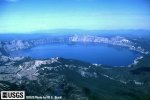 [Image,34K,JPG]
Aerial view Crater Lake Caldera, Oregon.
-- USGS Photo by W.E. Scott
From:
Tilling, 1985, Volcanoes: USGS General Interest Publication
-
An interesting variation of a
composite volcano
can be seen at
Crater Lake
in Oregon. From what geologists can interpret of its past, a high volcano --
called Mount Mazama -- probably similar in appearance to present-day Mount
Rainier was once located at this spot. Following a series of tremendous
explosions about 6,600 years ago, the volcano lost its top. Enormous volumes of
volcanic ash and dust were expelled and swept down the slopes as ash flows and
avalanches. These large-volume explosions rapidly drained the lava beneath the
mountain and weakened the upper part. The top then collapsed to form a large
depression, which later filled with water and is now completely occupied by
beautiful Crater Lake. A last gasp of eruptions produced a small
cinder cone
which rises above the water surface as Wizard Island in, and near the rim, of
the lake. Depressions such as Crater Lake, formed by collapse of volcanoes, are
known as calderas.
They are usually large, steep-walled, basin-shaped depressions formed by the
collapse of a large area over, and around, a volcanic vent or vents. Calderas
range in form and size from roughly circular depressions 1 to 15 miles in
diameter to huge elongated depressions as much as 60 miles long.
-
 Crater Lake Caldera Menu
From:
Tilling, Heliker, and Wright, 1987, Eruptions of Hawaiian Volcanoes:
Past, Present, and Future:
USGS General Interest Publication
-
Hawaiian and other
shield volcanoes
characteristically have a broad summit,
indented with a caldera, a term commonly used for a large depression of
volcanic origin. Most calderas form by collapse because of removal of magma
from the volcano's reservoir by eruption and/or intrusion. Kilauea's
summit caldera is about 2.5 miles long and 2 miles wide.
Mokuaweoweo, the summit caldera complex of Mauna Loa
is more elongate, measuring about 3 by 1.5 miles.
The terms crater or pit crater are applied to similar but smaller
collapse features. ...
-
If the
hot-spot theory
is correct, the next volcano in the Hawaiian chain should
form east or south of the big Island. Abundant evidence indicates that such a
new volcano exists at Loihi, a seamount (or submarine peak) located about
20 miles off the south coast of the Big Island. Loihi rises 10,100 feet
above the ocean floor to within 3,100 feet of the water surface. Recent
detailed mapping shows Loihi to be similar in form to Kilauea and Mauna Loa.
Its relatively flat summit apparently contains a caldera
about 3 miles across;
two distinct ridges radiating from the summit are probably rift zones.
-
 Link to: Hawaiian Volcano Observatory Website for MORE Information
From:
Newhall and Dzurisin, 1988,
Historical Unrest at Large Calderas of the World:
USGS Bulletin 1855
-
The
August 1883 eruption of Krakatau
is often cited as
a classic example of caldera formation
by collapse following eruption of large volumes of pumice (Williams, 1941; Williams and
McBirney, 1979; Self and Rampino, 1981, 1982; Francis and Self, 1983). However, other workers
have suggested alternate mechanisms for formation of the Krakatau Caldera. Yokoyama (1981,
1982) concluded that the caldera formed by explosive destruction and reaming of the
preeruption edifice, and Camus and Vincent (1983) and Francis (1985) favored an origin by
large-scale collapse of the northern part of Krakatau Island (similar to the
volcanic landslide at Mount St. Helens on 18 May 1980).
Regrettable, much of the evidence is sumbmarine and inaccessible, but we are impressed by the
similarity of Krakatau and other, better-exposed calderas (for example,
Crater Lake)
that are thought to have formed by simple collapse following voluminous pumice eruptions. The
volume of magma erupted in the plinian eruption (9 cubic kilometers) is adequate to explain
the caldera without invoking a landslide origin. ...
-
Indonesian Volcano Menu
|
Long Valley Caldera, California
|
From:
Hill, et.al., 1996,
Living With a Restless Caldera -- Long Valley, California:
USGS Fact Sheet 108-96
-
About 760,000 years ago a cataclysmic volcanic eruption in the
area blew out 150 cubic miles of
magma (molten rock) from
a depth of about 4 miles beneath the Earth's surface.
Rapidly moving
flows of glowing hot ash
covered much of east-central California, and
airborne ash
fell as far east as Nebraska.
The Earth's surface sank more than 1 mile into the
space once occupied by the erupted magma, forming a large
volcanic depression that geologists call a
caldera.
-
Today, Long Valley occupies the eastern half of this 10-mile-wide,
20-mile-long caldera. Magma still underlies the
caldera and heats underground water. The heated water feeds local
hot springs and natural steam vents and drives three
geothermal power plants,
producing a combined 40 megawatts of electricity.
-
The Long Valley Caldera is only one part of a large volcanic
system in eastern California that also includes the
Mono-Inyo Craters volcanic chain.
This chain extends from Mammoth Mountain
at the southwest rim of the caldera northward
25 miles to Mono Lake.
Eruptions along this chain began 400,000 years ago,
and Mammoth Mountain itself was formed by a
series of eruptions ending 50,000 years ago.
The volcanic system is still active. Scientists have determined that eruptions
occurred in both the Inyo Craters and Mono Craters parts of
the volcanic chain as recently as 600 years ago and that small
eruptions occurred in Mono Lake
sometime between the mid-1700's and mid-1800's.
From:
Bailey, Miller, and Sieh, 1989,
Field Guide to Long Valley Caldera and Mono-Inyo Craters Volcanic Chain, Eastern
California:
GSA Field Trip Guidebook T313
-
Long Valley
caldera
is located at the western edge of the Basin and Range
Province
straddling the eastern frontal fault escarpment of the Sierra Nevada,
in which it forms a reentrant or offset commonly referred to as the
"Mammoth embayment".
The floor of the caldera ranges in elevation from 2,000 meters in
its eastern half, where it is dominated by Lake Crowley and sage- and
grass-covered Long Valley,
to 2,600 meters in its western half, which is hillier
and heavily forested. The caldera walls rise steeply to elevations of 3,000 to
3,500 meters on all sides except the east and southeast, where the floor rises
only 150 meters before merging with the Volcanic Tableland
at 2,300 meters elevation. The Mono-Inyo Craters volcanic chain
extends from the western part of Long Valley caldera northward
from Mammoth Mountain
to Mono Lake, a distance of 50 kilometers.
-
 Link to: Long Valley Observatory Website for MORE Information
|
Medicine Lake Caldera, California
|
-
 [Image,65K,JPG]
Aerial view of Medicine Lake in the subdued caldera of Medicine Lake Volcano.
View is West-Southwest. Mount Shasta is on the skyline.
-- USGS Photo by Julie Donnelly-Nolan, September, 1985
From:
Dzurisin, 1992,
Geodetic Leveling as a Tool for Studying Restless Volcanoes,
IN: Ewert and Swanson, (editors), 1992,
Monitoring Volcanoes: Techniques and Strategies Used by the Staff of the Cascades Volcano Observatory,
1980-1990: USGS Bulletin 1966
-
Medicine Lake volcano
is a
Pleistocene and Holocene
shield volcano
located in
northeastern California about 50 kilometers east of
Mount Shasta,
near the western
margin of the Basin and Range tectonic province.
Lava Beds National Monument
is located on the northern flank of
Medicine Lake volcano
and encompasses mostly
basaltic and some andesitic lavas. Higher on the volcano, basaltic lava is
mostly absent, andesite dominates, and rhyolite and small volumes of dacite are
present, the latter mainly near the 7 x 12 kilometer
Medicine Lake caldera.
-
Medicine Lake Caldera Menu
|
Yellowstone Caldera, Wyoming
|
-
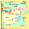 [Map,20K,InlineGIF]
Yellowstone National Park
showing caldera rim and location of 1959 and 1975 quakes
-- Modified from:
Dzurisin, et.al., 1995, USGS Open-File Report 95-59
From:
U.S. National Park Service Website,
Geology Fieldnotes - Yellowstone National Park, April 2000
-
At the heart of Yellowstone's past, present, and future lies volcanism. Catastrophic
eruptions occurred here about 2 million years ago, then 1.2 million years ago, and then
600,000 years ago.
The latest eruption spewed out nearly 240 cubic miles of debris. What is now the park's
central portion then collapsed, forming a 28- by 47- mile
caldera (or basin).
The magmatic
heat powering those eruptions still powers the park's famous geysers, hot springs, fumaroles,
and mud pots. The spectacular Grand Canyon of the Yellowstone River provides a glimpse of
Earth's interior: its waterfalls highlight the boundaries of lava flows and thermal areas.
Rugged mountains flank the park's volcanic plateau, rewarding both eye and spirit.
-
Yellowstone Caldera Menu
Return to:
[Caldera and Caldera Formation Menu] ...
[Volcano Types Menu] ...
[Glossary of Hazards, Features, and Terminology] ...

URL for CVO HomePage is:
<http://vulcan.wr.usgs.gov/home.html>
URL for this page is:
<http://vulcan.wr.usgs.gov/Glossary/Caldera/description_caldera.html>
If you have questions or comments please contact:
<GS-CVO-WEB@usgs.gov>
04/26/07, Lyn Topinka
 [Image,34K,JPG]
 [Image,65K,JPG]