
Available Data
- Gulf of Mexico:
- Atlantic:
- Pacific:
- Alaska:
- Hawaii:
|
Data Products
Sediment Data - usSEABED Atlantic Coast Data Release 1.0
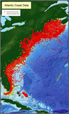
This publication is the first release of the Atlantic coast data from the usSEABED database. The report contains a compilation of published and unpublished sediment texture and other geologic data about the seafloor from diverse sources. usSEABED is an innovative database system developed to bring assorted data together in a unified database. The dbSEABED system is used to process the data. Examples of maps displaying attributes such as grain size and sediment color are included. This database contains information that is the scientific foundation for the USGS Marine Aggregate Resources and Processes Assessment and Benthic Habitats projects and will be useful to the marine science community for other studies of the Atlantic coast continental margin.
Download the data: Surficial Sediment Data Release version 1.0
Google Earth Files : Coming Soon!
|
Sediment Data - usSEABED Gulf of Mexico Data Release 1.0

This publication is the first release of the Gulf of Mexico coast data from the usSEABED database. The report contains a compilation of published and unpublished sediment texture and other geologic data about the seafloor from diverse sources. usSEABED is an innovative database system developed to bring assorted data together in a unified database. The dbSEABED system is used to process the data. Examples of maps displaying attributes such as grain size and sediment color are included. This database contains information that is the scientific foundation for the USGS Marine Aggregate Resources and Processes Assessment and Benthic Habitats projects and will be useful to the marine science community for other studies of the Gulf of Mexico coast continental margin.
Download the data: Surficial Sediment Data Release version 1.0
Google Earth Files : Coming Soon!
|
Sediment Data - usSEABED Pacific Data Release 1.0

Data Series 182, This publication is the first release of the Pacific coast data from the usSEABED database. The report contains a compilation of published and unpublished sediment texture and other geologic data about the sea floor from diverse sources. usSEABED is an innovative database system developed to unify assorted data, with the data processed by the dbSEABED system. Examples of maps displaying attributes such as grain size and sediment color are included. This database contains information that is a scientific foundation for the U.S. Geological Survey (USGS) Sea floor Mapping and Benthic Habitats project and the Marine Aggregate Resources and Processes assessment project, and will be useful to the marine science community for other studies of the Pacific coast continental margin.
Download the data: Surficial Sediment Data Release version 1.0
|
GIS Compilation - New York and New Jersey Offshore Sediment Character

Open-File Report 2006-1046, This Report is based on data contained in DS-118 (Reid and others, 2005) and shows an assortment of example GIS products that are possible using usSEABED. All data are intended to be GIS-ready and the data should not require any additional cleanup, formatting, or renaming of fields in order to use the data in a Geographic Information System. This project employs the Environmental Systems Research Institute's (ESRI) ArcView? software. Many of these maps were made as part of the ongoing USGS study to assess marine aggregate resources offshore New York and New Jersey, but these maps can serve many other purposes. The marine science community, educators, students and others are encouraged to use these data to generate GIS products for their own purposes.
Download the data: Open File Report 2006-1046
Google Earth Files : Coming Soon!
|
GIS Compilation - Louisiana Offshore Sediment Character

Open-File Report 2006-1195, This Report is based on data contained in DS-146 (Buczkowski and others, 2006) and shows an assortment of example GIS products that are possible using usSEABED. All data are intended to be GIS-ready and the data should not require any additional cleanup, formatting, or renaming of fields in order to use the data in a Geographic Information System. This project employs the Environmental Systems Research Institute's (ESRI) ArcView? software. Many of these maps were made as part of the ongoing USGS study to assess marine aggregate resources offshore Louisiana, but these maps can serve many other purposes. The marine science community, educators, students and others are encouraged to use these data to generate GIS products for their own purposes.
Download the data: Open File Report 2006-1195
Google Earth Files : Coming Soon!
|
|
Related Links:
Google Earth
|

 U.S. Department of the Interior |
U.S. Geological Survey
U.S. Department of the Interior |
U.S. Geological Survey