|
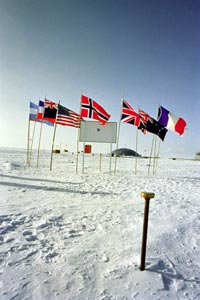
Geographic South Pole
The copper pipe marks the exact spot of 90
degrees South latitude as determined
each January using the satellite-based
Global Positioning System, or GPS.
In the mid-background are flags of
the original 12 signatory nations to the
Antarctic Treaty. In the background is the
geodesic dome housing facilities of
Amundsen-Scott South Pole Station.
Photo Credit: Lynn Teo Simarski,
National Science Foundation
|
Australian Antarctic Division
(http://www.aad.gov.au/)
The AAD is the lead agency for Australia's Antarctic program.
Provides information about Australia's Antarctic stations, the
science and environment of Antarctica
Polar
Regions
(http://www4.ncsu.edu/~leung/intl/pola/webpage.html)
Focuses on the tourism and environmental impact on the polar regions
of the Arctic and Antarctica.
U.S. Antarctic Resource Center
(USARC)
(http://usarc.usgs.gov/)
At the U.S. Geological Survey (USGS), Reston,Va., USARC maintains
the most comprehensive national collection of Antarctic maps,
charts, satellite images, and photographs produced by the United
States and other member nations of the Scientific Committee on
Antarctic Research (SCAR). Its holdings include maps and charts
from Argentina, Australia, Belgium, Brazil, Chile, China, Ecuador,
Finland, France, Germany, India, Italy, Japan, Korea, Netherlands,
New Zealand, Norway, Peru, Poland, Russia, South Africa, Spain,
Sweden, the United Kingdom, the United States, and Uruguay.
USGS Atlas of
Antarctic Research
(http://usarc.usgs.gov/lidar_dload.shtml)
Describes ongoing and past projects. Provides a common base for
displaying research results and data collected. Intended primarily
as a tool for Antarctic researchers.
World
Fact Book 2008 (https://www.cia.gov/library/publications/the-world-factbook/geos/ay.html)
|