Link to USGS home page Link to USGS home page
Coastal and Marine Geology Program
Coastal & Marine Geology Program > Center for Coastal and Watershed Studies > West-Central Florida Coastal Studies Project > Virtual Field Trip

West-Central Florida Coastal Studies Project

West-Central Florida Coastal Studies Home
Virtual Field Trip:
Introduction
Anclote Key
Three-Rooker Bar
Dunedin Pass
Sand Key
St. Pete Beach
Mullet and Egmont Keys
Anna Maria Island
Longboat and Lido Keys
Venice Inlet
Contact:
Chief Scientist

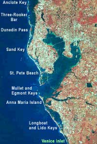
Virtual Field Trip - Venice Inlet

map of west-central Florida study area
Anclote Key Three-Rooker Bar Dunedin Pass Sand Key St. Pete Beach Mullet and Egmont Keys Anna Maria Island Longboat and Lido Keys

Venice Inlet locator map
Venice Inlet was chosen as the southern boundary for the study area because it marks the end of the chain of barrier islands included in this study. The coastal area directly south of the inlet is not protected by barrier islands, though they reappear further to the south.

Venice Inlet
Oblique aerial photograph of Venice Inlet, looking west.

Coastal & Marine Geology Program > Center for Coastal and Watershed Studies > West-Central Florida Coastal Studies Project > Virtual Field Trip


FirstGov.gov U. S. Department of the Interior | U.S. Geological Survey
Center for Coastal & Regional Marine Studies

email Feedback | USGS privacy statement | Disclaimer | Accessibility

This page is http://coastal.er.usgs.gov/wfla/vft/venice/index.html
Updated March 24, 2004 @ 03:45 PM  (JSS)