|
|
 |
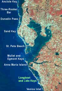
Virtual Field Trip - Longboat and Lido Keys
Separated from Anna Maria Island to the north by Longboat Pass, Longboat Key is a ten mile long
barrier island. To the south, Lido Key was formed artificially in the 1920's when a series of small
mangrove islands were filled with dredge material from New Pass.
A portion of this area was surveyed using a highly detailed sidescan-sonar mosaic.
A sonar unit was towed behind a boat, creating a mosaic by overlapping transect lines. The completed survey
was used to create an interpretive map of the seafloor surface.
| Below: Oblique aerial photograph of Longboat Key, looking west out over the Gulf of Mexico. |
|
 |
|
 |
| Above: Oblique aerial photograph of Lido Key, looking northeast. |
|