
 Feeds & Data
Magnitude 6.9 - PHILIPPINE ISLANDS REGION
2008 March 03 14:11:14 UTC
Earthquake Details
| Magnitude | 6.9 |
|---|---|
| Date-Time |
|
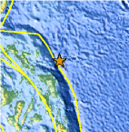
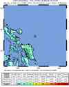
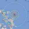
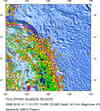
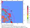
| Location | 13.357°N, 125.665°E |
| Depth | 24 km (14.9 miles) set by location program |
| Region | PHILIPPINE ISLANDS REGION |
| Distances | 175 km (110 miles) ESE of Pandan, Catanduanes, Philippines 180 km (110 miles) NE of Calbayog, Samar, Philippines 210 km (130 miles) E of Legaspi, Luzon, Philippines 525 km (325 miles) ESE of MANILA, Philippines |
| Location Uncertainty | horizontal +/- 4.5 km (2.8 miles); depth fixed by location program |
| Parameters | NST=238, Nph=238, Dmin=>999 km, Rmss=0.87 sec, Gp= 43°, M-type=moment magnitude (Mw), Version=S |
| Source |
|
| Event ID | us2008pdbs |
- This event has been reviewed by a seismologist.
- Did you feel it? Report shaking and damage at your location. You can also view a map displaying accumulated data from your report and others.
Earthquake Summary

The following is a release by the United States Geological Survey, National Earthquake Information Center: An earthquake occurred about 175 km (110 mi) east-southeast of Pandan, Catanduanes at 7:11 AM MST, Mar 3, 2008 (10:11 PM local time in Philippines). The magnitude and location may be revised when additional data and further analysis results are available. No reports of damage or casualties have been received at this time; however, this earthquake may have caused damage due to its location and size.
Felt Reports
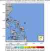
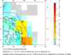
Felt (IV) at Naga and (II) at Manila. Also felt at Cebu, Iriga, Legaspi, Solano and Tacloban.
 Tsunami Information
- NOAA West Coast & Alaska Tsunami Warning Center
- NOAA Pacific Tsunami Warning Center
- Tsunami Information Links
The earthquake locations and magnitudes cited in these NOAA tsunami bulletins are very preliminary and may be superceded by USGS locations and magnitudes computed using more extensive data sets.
Earthquake Maps

Scientific & Technical Information

- Preliminary Earthquake Report
- U.S. Geological Survey, National Earthquake Information Center:
World Data Center for Seismology, Denver
