
 Feeds & Data
Magnitude 6.7 - SOUTH SANDWICH ISLANDS REGION
2008 February 23 15:57:20 UTC
Earthquake Details
| Magnitude | 6.7 |
|---|---|
| Date-Time |
|
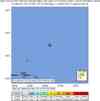
| Location | 57.072°S, 23.398°W |
| Depth | 10 km (6.2 miles) set by location program |
| Region | SOUTH SANDWICH ISLANDS REGION |
| Distances | 240 km (150 miles) E of Visokoi Island, South Sandwich Islands 285 km (175 miles) NE of Bristol Island, South Sandwich Islands 3645 km (2260 miles) SE of BUENOS AIRES, Argentina |
| Location Uncertainty | horizontal +/- 9.8 km (6.1 miles); depth fixed by location program |
| Parameters | NST=175, Nph=175, Dmin=>999 km, Rmss=1.15 sec, Gp= 25°, M-type=moment magnitude (Mw), Version=9 |
| Source |
|
| Event ID | us2008nud7 |
- This event has been reviewed by a seismologist.
- Did you feel it? Report shaking and damage at your location. You can also view a map displaying accumulated data from your report and others.
Earthquake Summary


The following is a release by the United States Geological Survey, National Earthquake Information Center: An earthquake occurred 225 km (140 miles) ESE of Visokoi Island, South Sandwich Islands at 8:57 AM MST, Feb 23, 2008 (1:57 PM local time in South Sandwich Is.). The magnitude and location may be revised when additional data and further analysis results are available. There have been no reports of damage. The magnitude was furnished by the G.S.
Felt Reports
WP 6.8 (GS).
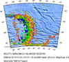
Earthquake Maps


Scientific & Technical Information

- Preliminary Earthquake Report
- U.S. Geological Survey, National Earthquake Information Center:
World Data Center for Seismology, Denver
