
 Feeds & Data
Magnitude 6.5 - KERMADEC ISLANDS, NEW ZEALAND
2007 January 31 03:15:55 UTC
Earthquake Details
| Magnitude | 6.5 |
|---|---|
| Date-Time |
|
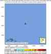
| Location | 29.593°S, 177.935°W |
| Depth | 53.7 km (33.4 miles) |
| Region | KERMADEC ISLANDS, NEW ZEALAND |
| Distances | 55 km (35 miles) SSW of Raoul Island, Kermadec Islands 210 km (130 miles) NNE of L'Esperance Rock, Kermadec Islands 1035 km (650 miles) NE of Auckland, New Zealand 1440 km (890 miles) NNE of WELLINGTON, New Zealand |
| Location Uncertainty | horizontal +/- 9.2 km (5.7 miles); depth +/- 4.5 km (2.8 miles) |
| Parameters | NST=175, Nph=175, Dmin=37.9 km, Rmss=0.96 sec, Gp= 29°, M-type=moment magnitude (Mw), Version=7 |
| Source |
|
| Event ID | us2007yfak |
- This event has been reviewed by a seismologist.
- Did you feel it? Report shaking and damage at your location. You can also view a map displaying accumulated data from your report and others.
Earthquake Summary


The following is a release by the United States Geological Survey, National Earthquake Information Center: A strong earthquake occurred about 40 km (25 miles) S of Raoul Island, Kermadec Islands or about 1050 km (650 miles) NE of Auckland, New Zealand at 9:15 PM MDT, Jan 30, 2007 (Jan 31 at 3:15 PM local time in New Zealand). The magnitude and location may be revised when additional data and further analysis results are available. There have been no reports of damage.
 Tsunami Information
- NOAA Tsunami Warning Center
- Recent Tsunamis
- Tsunami Information Links
The earthquake locations and magnitudes cited in these bulletins are very preliminary, and may disagree with the more accurate USGS locations and magnitudes computed using more extensive data sets.
Earthquake Maps


Scientific & Technical Information

- Preliminary Earthquake Report
- U.S. Geological Survey, National Earthquake Information Center:
World Data Center for Seismology, Denver
