
 Feeds & Data
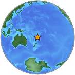
Magnitude 7.8 - SOUTH OF THE FIJI ISLANDS
2007 December 09 07:28:20 UTC
Earthquake Details
| Magnitude | 7.8 |
|---|---|
| Date-Time |
|
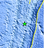
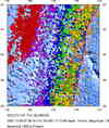
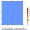
| Location | 25.872°S, 177.517°W |
| Depth | 149.2 km (92.7 miles) |
| Region | SOUTH OF THE FIJI ISLANDS |
| Distances | 355 km (220 miles) N of Raoul Island, Kermadec Islands 590 km (365 miles) SSW of NUKU'ALOFA, Tonga 1410 km (870 miles) NNE of Auckland, New Zealand 1830 km (1140 miles) NNE of WELLINGTON, New Zealand |
| Location Uncertainty | horizontal +/- 11.1 km (6.9 miles); depth +/- 18.4 km (11.4 miles) |
| Parameters | NST=124, Nph=124, Dmin=376.4 km, Rmss=1.33 sec, Gp= 22°, M-type=moment magnitude (Mw), Version=7 |
| Source |
|
| Event ID | us2007ksak |
- This event has been reviewed by a seismologist.
- Did you feel it? Report shaking and damage at your location. You can also view a map displaying accumulated data from your report and others.
Earthquake Summary
The following is a release by the United States Geological Survey, National Earthquake Information Center: An earthquake occurred 345 km (215 miles) N of Raoul Island, Kermadec Islands; 600 km (370 miles) SSW of NUKU'ALOFA, Tonga; 1395 km (870 miles) NE of Auckland, New Zealand; 1830 km (1130 miles) NNE of WELLINGTON, New Zealand at 12:28 AM MST, Dec 9, 2007 (7:28 PM local time in .). The magnitude and location may be revised when additional data and further analysis results are available. This earthquake is located in a remote area and no damage or casualties are expected.
Felt Reports
Felt (IV) at Nuku`alofa, and felt at Mu`a, Neiafu, Pangai and Vaini, Tonga. Felt at Alofi, Niue. Also felt throughout the North Island of New Zealand and specifically at Lower Hutt, Napier, Wellington and Whakatane.
Tectonic Summary
The December 9, 2007, earthquake occurred in the Tonga Kermadec subduction zone. The subduction zone, which is situated from the North Island of New Zealand to the north-northeast, is about 2500 km long. At a broad scale, tectonics of the subduction zone reflect the motion of the Pacific plate westward with respect to the interior of the Australia plate at a velocity of about 77 mm/y. The Pacific plate subducts beneath the Australia plate at the Tonga and Kermadec trenches, and dips to the west. In detail, the eastern edge of the broad Australia plate may itself be viewed as a collection of small plates or microplates that move with respect to each other and with respect to the Pacific plate and the Australia plate interior.
The interaction between the Pacific and Australia plate creates one of the most active tectonic environments in the world, with a high level of associated earthquake activity. Earthquakes occur on the thrust-fault interface between the Pacific and Australia plates, within the overriding Australia plate, and within the subducting Pacific plate. The December 9 earthquake occurred at depth of about 150 km within the Pacific plate and reflects stresses generated by the deformation of the Pacific plate as it is subducted. Earthquakes, such as this one, that have focal depths between 70 and 300 km are commonly termed intermediate-depth earthquakes. Deep-focus earthquakes, with focal depths greater than 300 km, also occur in the subducted Pacific plate in the Tonga Kermadec subduction zone. Earthquakes have been reliably located to depths of nearly 700 km within the subduction zone.
 Tsunami Information
- NOAA West Coast & Alaska Tsunami Warning Center
- NOAA Pacific Tsunami Warning Center
- Tsunami Information Links
The earthquake locations and magnitudes cited in these NOAA tsunami bulletins are very preliminary and may be superceded by USGS locations and magnitudes computed using more extensive data sets.
Earthquake Maps

Scientific & Technical Information

- Preliminary Earthquake Report
- U.S. Geological Survey, National Earthquake Information Center:
World Data Center for Seismology, Denver
