
 Feeds & Data
Magnitude 6.8 - EASTERN NEW GUINEA REG, PAPUA NEW GUINEA
2007 November 22 08:48:29 UTC
Earthquake Details
| Magnitude | 6.8 |
|---|---|
| Date-Time |
|
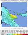
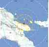
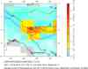
| Location | 5.795°S, 147.113°E |
| Depth | 72.7 km (45.2 miles) set by location program |
| Region | EASTERN NEW GUINEA REG, PAPUA NEW GUINEA |
| Distances | 110 km (70 miles) N of Lae, New Guinea, PNG 155 km (95 miles) ESE of Madang, New Guinea, PNG 410 km (255 miles) N of PORT MORESBY, Papua New Guinea 2490 km (1540 miles) NNW of BRISBANE, Queensland, Australia |
| Location Uncertainty | horizontal +/- 4.5 km (2.8 miles); depth fixed by location program |
| Parameters | NST=204, Nph=204, Dmin=999.5 km, Rmss=0.91 sec, Gp= 22°, M-type=moment magnitude (Mw), Version=Q |
| Source |
|
| Event ID | us2007kaaq |
- This event has been reviewed by a seismologist.
- Did you feel it? Report shaking and damage at your location. You can also view a map displaying accumulated data from your report and others.
Earthquake Summary


The following is a release by the United States Geological Survey, National Earthquake Information Center: An earthquake occurred 100 km (60 miles) N of Lae, New Guinea, PNG and 400 km (250 miles) N of PORT MORESBY, Papua New Guinea at 1:48 AM MST, Nov 22, 2007 (6:48 PM local time in Papua New Guinea). The magnitude and location may be revised when additional data and further analysis results are available. There have been no reports of damage.
Felt Reports
Damage to a water tower and knocked out power at Lae. Loose items were dislodged and damaged. Felt (V) at Lae. Also felt at Bulolo, Goroka, Kainantu and Port Moresby.
Earthquake Information for Australia
 Tsunami Information
- NOAA West Coast & Alaska Tsunami Warning Center
- NOAA Pacific Tsunami Warning Center
- Tsunami Information Links
The earthquake locations and magnitudes cited in these NOAA tsunami bulletins are very preliminary and may be superceded by USGS locations and magnitudes computed using more extensive data sets.
Earthquake Maps


Scientific & Technical Information

- Preliminary Earthquake Report
- U.S. Geological Survey, National Earthquake Information Center:
World Data Center for Seismology, Denver
