
 Feeds & Data
Magnitude 6.6 - AUCKLAND ISLANDS, NEW ZEALAND REGION
2007 September 30 09:47:49 UTC
Earthquake Details
| Magnitude | 6.6 |
|---|---|
| Date-Time |
|
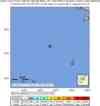
| Location | 49.409°S, 163.265°E |
| Depth | 10 km (6.2 miles) set by location program |
| Region | AUCKLAND ISLANDS, NEW ZEALAND REGION |
| Distances | 225 km (140 miles) NW of Auckland Island, New Zealand 500 km (310 miles) SW of Invercargill, New Zealand 1260 km (790 miles) SW of WELLINGTON, New Zealand 1950 km (1210 miles) SSE of CANBERRA, A.C.T., Australia |
| Location Uncertainty | horizontal +/- 9.5 km (5.9 miles); depth fixed by location program |
| Parameters | NST=228, Nph=228, Dmin=>999 km, Rmss=1.22 sec, Gp= 32°, M-type=moment magnitude (Mw), Version=S |
| Source |
|
| Event ID | us2007hxax |
- This event has been reviewed by a seismologist.
- Did you feel it? Report shaking and damage at your location. You can also view a map displaying accumulated data from your report and others.
Earthquake Summary


The following is a release by the United States Geological Survey, National Earthquake Information Center: An earthquake occurred 240 km (150 miles) WNW of Auckland Island, New Zealand 505 km (315 miles) SW of Invercargill, New Zealand 1275 km (790 miles) SW of WELLINGTON, New Zealand 1935 km (1200 miles) SSE of CANBERRA, A.C.T., Australia at 3:47 AM MDT, Sep 30, 2007 (8:47 PM local time in Auckland Islands). The magnitude and location may be revised when additional data and further analysis results are available. This earthquake is located in a remote area and no damage or casualties are expected.
Felt Reports
Felt (IV) at Invercargill and (III) at Dunedin; felt at Queenstown, South Island.
 Tsunami Information
- West Coast & Alaska Tsunami Warning Center
- Pacific Tsunami Warning Center
- NOAA Tsunami Warning Center
- Recent Tsunamis
- Tsunami Information Links
The earthquake locations and magnitudes cited in these bulletins are very preliminary, and may disagree with the more accurate USGS locations and magnitudes computed using more extensive data sets.
Earthquake Maps


Scientific & Technical Information

- Preliminary Earthquake Report
- U.S. Geological Survey, National Earthquake Information Center:
World Data Center for Seismology, Denver
