
 Feeds & Data
Magnitude 7.5 - VOLCANO ISLANDS, JAPAN REGION
2007 September 28 13:38:58 UTC
Earthquake Details
| Magnitude | 7.5 |
|---|---|
| Date-Time |
|
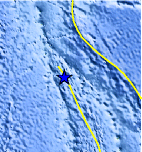
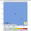
| Location | 21.980°N, 142.685°E |
| Depth | 261.3 km (162.4 miles) |
| Region | VOLCANO ISLANDS, JAPAN REGION |
| Distances | 285 km (175 miles) NW of Farallon de Pajaros, N. Mariana Islands 340 km (210 miles) SSE of Iwo-jima, Volcano Islands, Japan 810 km (510 miles) NNW of SAIPAN, Northern Mariana Islands 960 km (600 miles) NNW of HAGATNA, Guam |
| Location Uncertainty | horizontal +/- 5.5 km (3.4 miles); depth +/- 15 km (9.3 miles) |
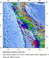
| Parameters | NST= 99, Nph= 99, Dmin=956.3 km, Rmss=0.78 sec, Gp= 29°, M-type=moment magnitude (Mw), Version=8 |
| Source |
|
| Event ID | us2007hvbq |
- This event has been reviewed by a seismologist.
- Did you feel it? Report shaking and damage at your location. You can also view a map displaying accumulated data from your report and others.
Earthquake Summary

The following is a release by the United States Geological Survey, National Earthquake Information Center: An earthquake occurred 280 km (175 miles) NW of Farallon de Pajaros, N. Mariana Islands at 7:38 AM MDT, Sep 28, 2007 (11:38 PM local time in United States). The magnitude and location may be revised when additional data and further analysis results are available. No damage is expected.
Tectonic Summary
The Mariana Islands earthquake of September 28, 2007, occurred in the inclined seismic zone that marks the position of the subducted Pacific plate beneath the overriding Philippine Sea plate. The Pacific plate moves to the west with respect to the Philippine Sea plate with a velocity of about 40 mm/yr and thrusts under the Philippine Sea plate at the Mariana Trench. The earthquake represents the release of stress resulting from the distortion of the Pacific plate.
Earthquakes, such as this one, that have focal depths between 70 and 300 km are commonly termed "intermediate-depth" earthquakes. "Deep-focus" earthquakes, with focal depths greater than 300 km, also occur in the subducted Pacific plate beneath the Mariana island arc. Earthquakes have been reliably located to depths of about 630 km beneath the Marianas arc
 Tsunami Information
- West Coast & Alaska Tsunami Warning Center
- Pacific Tsunami Warning Center
- NOAA Tsunami Warning Center
- Recent Tsunamis
- Tsunami Information Links
The earthquake locations and magnitudes cited in these bulletins are very preliminary, and may disagree with the more accurate USGS locations and magnitudes computed using more extensive data sets.
Earthquake Maps


Scientific & Technical Information

- Preliminary Earthquake Report
- U.S. Geological Survey, National Earthquake Information Center:
World Data Center for Seismology, Denver
